- Mehrnbach
-
Mehrnbach 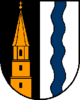
 Mehrnbach
Country Austria State Upper Austria District Ried im Innkreis Mayor Peter Bahn (FPÖ) Area 22.2 km2 (9 sq mi) Elevation 443 m (1453 ft) Population 2,327 (1 January 2011)[1] - Density 105 /km² (271 /sq mi) Time zone CET/CEST (UTC+1/+2) Postal codes A-4941 Area codes +43 7752 Website www.mehrnbach.at Coordinates: 48°12′32″N 13°26′11″E / 48.20889°N 13.43639°E
Mehrnbach is a municipality in Upper Austria. It is situated in the district of Ried im Innkreis in the Innviertel and has 2,305 inhabitants. The responsible jurisdiction is Ried im Innkreis.
Contents
Geography
Mehrnbach is situated 443 m above sea level in the Innviertel. Its dimensions are 6.2 km from the North to the South and 6.5 km from the West to the East. The complete area accounts for 22.2 km². 14.9 % of the land is afforested, whilst 73.9 % is used agriculturally. Parts of the municipality are Abstätten, Aich, Asenham, Atzing, Aubach, Aubachberg, Baching, Bubesting, Dopplhub, Fritzging, Gigling, Käfermühl, Langdorf, Mehrnbach, Probenzing, Renetsham, Riegerting, Sieber, Stötten, Steinbach, Thaling, and Zimetsberg.
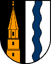
Coat of arms
The official description of the coat of arms (translation): Split; to the right in black a golden church tower, which comes out of the shield bottom, with two square basements, one octagonal upper floor with abutments, and an octagonal pitched roof, crowned with bowl and cross, the floors separated by cornices, in the lowest floor two rectangular apertures, in the upper floor one lancet arched window; to the left in silver a blue wavy pile. The municipal colours are white and blue.
History
From the foundation of the Bavarian dukedom the city belonged to Bavaria until 1780. Together with the Innviertel (formerly known as "Innbaiern") it was ceded to Austria after the Treaty of Teschen. During the French Revolutionary Wars it became Bavarian again, in 1814 it became part of Upper Austria to whom it has belonged up to the present day. After the Anschluß to the German Reich on March 13, 1938 the city was part of the "Gau Oberdonau". After 1945 the restitution of Upper Austria took place.
Politics
The mayor of Mehrnbach is Peter Bahn (FPÖ).
Population development
According to the population census in 1991 the municipality had 2,079 inhabitants, and 2,305 inhabitants in 2001.
References
- This article incorporates information from this version of the equivalent article on the German Wikipedia.
Andrichsfurt · Antiesenhofen · Aurolzmünster · Eberschwang · Eitzing · Geiersberg · Geinberg · Gurten · Hohenzell · Kirchdorf am Inn · Kirchheim im Innkreis · Lambrechten · Lohnsburg · Mehrnbach · Mettmach · Mörschwang · Mühlheim am Inn · Neuhofen im Innkreis · Obernberg am Inn · Ort im Innkreis · Pattigham · Peterskirchen · Pramet · Reichersberg · Ried im Innkreis · Sankt Georgen bei Obernberg am Inn · Sankt Marienkirchen am Hausruck · Sankt Martin im Innkreis · Schildorn · Senftenbach · Taiskirchen im Innkreis · Tumeltsham · Utzenaich · Waldzell · Weilbach · Wippenham
Categories:- Cities and towns in Upper Austria

Wikimedia Foundation. 2010.