- Oirase River
-
Oirase River
奥入瀬川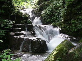
Oirase River gorgeOrigin Lake Towada, Aomori & Akita Prefectures, Japan Mouth Pacific Ocean Length 67 km (42 mi) Source elevation 401 m (1,316 ft) Mouth elevation 0 m (0 ft) Basin area 820 km2 (320 sq mi) The Oirase River (奥入瀬川 Oirase-gawa) is a river located in eastern Aomori prefecture, Japan.
The Oirase River is the only river draining Lake Towada, a large caldera lake on the border of Aomori and Akita Prefectures. The river flows in a generally eastern direction, through the municipalities of Towada, Rokunohe, Oirase and Hachinohe before exiting into the Pacific Ocean. The upper reaches of the river form a scenic gorge with numerous rapids and waterfalls, and is one of the major tourist attractions of the Towada-Hachimantai National Park. The lower reaches of the river are used extensively for irrigation.
See also
- 100 Soundscapes of Japan
External links
40°36′18″N 141°27′48″E / 40.604937°N 141.463306°ECoordinates: 40°36′18″N 141°27′48″E / 40.604937°N 141.463306°E (river mouth)

This Aomori Prefecture location article is a stub. You can help Wikipedia by expanding it.
