- Dachsbach
-
Dachsbach 
Coordinates 49°38′N 10°42′E / 49.63333°N 10.7°ECoordinates: 49°38′N 10°42′E / 49.63333°N 10.7°E Administration Country Germany State Bavaria Admin. region Middle Franconia District Neustadt a.d.Aisch-Bad Windsheim Municipal assoc. Uehlfeld Local subdivisions 5 Ortsteile Mayor Hans-Jürgen Regus (Einigkeit Oberhöchstädt) Basic statistics Area 20.58 km2 (7.95 sq mi) Elevation 280 m (919 ft) Population 1,787 (31 December 2010)[1] - Density 87 /km2 (225 /sq mi) Other information Time zone CET/CEST (UTC+1/+2) Licence plate NEA Postal code 91462 Area code 09163 Website www.dachsbach.de Dachsbach is a so called "Marktgemeinde" (i.e. a little town having the right to have a market within its borders), a municipality in the district of Neustadt (Aisch)-Bad Windsheim, in the administrative region of Middle Franconia in northern Bavaria in Germany.
Contents
Geography
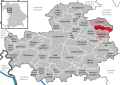
Dachsbach is located in the valley of the Aisch. The borough Rauschenberg is on the southern hills of the Steigerwald. The neighbouring municipalities are (from the north in clockwise direction): Uehlfeld, Weisendorf, Gerhardshofen and Gutenstetten. The municipality has five boroughs: Arnshöchstädt, Traishöchstädt, Göttelbrunn, Oberhöchstädt and Rauschenberg with Ziegelhütte.
History
The first documented notice of Dachsbach is from 1129 - a Knight Heinrich von Dachsbach sold one of his properties to the monastery St. Michael in Bamberg. In 1132 there was a witness with name Knight Albrecht von Dachsbach for the foundation of the monastery Heilsbronn. From 1298 until 1347 there was a Knight Konrad von Dachsbach reeve of the monastery of Münchsteinach. On April 14, 1280 the castle was pledged to the burgraves of Nuremberg, who made an official residence of it and built up Dachsbach as a bastion against the Cathedral Foundation Bamberg. Until 1797 the official residence remained in Dachsbach. At this time Neustadt an der Aisch became the central residence in the valley of the Aisch. Until this time the blood court for up to 41 surrounding areas was localized in the bailiff's office. The gallows at Galgenberg (i.e. Gallows Hill) were broken down in 1814.
Several wars have left their marks in Dachsbach. In the First Markgrave War (1449–1450) and the Second Markgrave War (1552–1555) troops from Nuremberg, in the Peasants' War the rebellious peasants occupied and raided Dachsbach. On November 12, 1553 Albrecht Alcibiades burned down his own castle to "learn the Nuremberg moneybags the bourning". In the Thirty Years' War (August 10, 1634) troops from Forchheim destroyed Dachsbach nearly complete. They only left the church, the tithe barn and six houses. At the beginning of the Thirty Years' War the mint of the markgrave in Dachsbach manufactured "Bad Thaler" (worth 120 Kreutzer), which had the size of full-fledged Thaler, but were made of low-grade silver with a high copper fraction.
The end of the bailiff-time in Dachsbach was 1797. At this time the bailiff Herrgott (i.e. God) resided in Dachsbach. To him the proverb "living like God in Dachsbach" and the naming "God's heads" for the citizens of Dachsbach are traced back. In August 1798 he interrogated a custodian and initiated the smashing of the "Big Franconian Thieves and Robber Gang". But his end was not very "God-like": He got into custody in Bamberg in 1806 for breach of duty. Since then Dachsbach passed a contemplative existence and can document its partly outstanding regional importance only with its cultural monuments.
Cultural Monuments
- Tower House of the Water Castle
- Old Bailiff Office
- Round Bastion
- Church of Our Lady
- Old and New Castle Rauschenberg
- Old Tavern Oberhöchstädt
Ecclesiastic
- Protestant Church Community - Church Choir Dachsbach
- Protestant Rural Youth Association Dachsbach
- Protestant Church Community Oberhöchstädt
- Protestant Rural Youth Association Oberhöchstädt
Theatre
- Dachsbacher Burgtheater e.V.
Culinary Specialties
Carps of the valley of the Aisch in the local gastronomy.
Economics and Infrastructure
Federal highway B 470 is directed from north-east to south-west through the community area.
From July 12, 1904 until May 30, 1976 there wa a railway from Neustadt (Aisch) to Demantsfürth-Uehlfeld called Aischtalbahn which lead to the railway Nuremberg Würzburg. It was broken down and since then only busses connect Dachsbach with the surrounding areas. The lines belong to the pay scale area of VGN.
Personalities
Literature
- In Goethe „Götz von Berlichingen" in the first act Götz calls „Geh auf den Weg nach Dachsbach!“ (i.e. „Move on the way to Dachsbach!“), which is roughly on the way from Jagsthausen to Bamberg.
Bad Windsheim | Baudenbach | Burgbernheim | Burghaslach | Dachsbach | Diespeck | Dietersheim | Emskirchen | Ergersheim | Gallmersgarten | Gerhardshofen | Gollhofen | Gutenstetten | Hagenbüchach | Hemmersheim | Illesheim | Ippesheim | Ipsheim | Langenfeld | Markt Bibart | Markt Erlbach | Markt Nordheim | Markt Taschendorf | Marktbergel | Münchsteinach | Neuhof an der Zenn | Neustadt an der Aisch | Oberickelsheim | Obernzenn | Oberscheinfeld | Scheinfeld | Simmershofen | Sugenheim | Trautskirchen | Uehlfeld | Uffenheim | Weigenheim | WilhelmsdorfReferences
- ^ "Fortschreibung des Bevölkerungsstandes" (in German). Bayerisches Landesamt für Statistik und Datenverarbeitung. 31 December 2010. https://www.statistikdaten.bayern.de/genesis/online?language=de&sequenz=tabelleErgebnis&selectionname=12411-009r&sachmerkmal=QUASTI&sachschluessel=SQUART04&startjahr=2010&endjahr=2010.
Categories:- Municipalities in Bavaria
- Neustadt (Aisch)-Bad Windsheim
Wikimedia Foundation. 2010.


