- Middle Franconia
-
Middle Franconia (district)
MittelfrankenMap of Bavaria highlighting the Regierungsbezirk of Middle Franconia (district)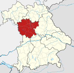
Country Germany State Bavaria Region seat Ansbach Area - Total 7,245.70 km2 (2,797.6 sq mi) Population (31 December 2010)[1] - Total 1,711,566 - Density 236.2/km2 (611.8/sq mi) Website regierung.mittelfranken.bayern.de Middle Franconia (German: Mittelfranken) is one of the three administrative regions of Franconia in Bavaria, Germany. It is in the west of Bavaria and adjoins the state of Baden-Württemberg. The administrative seat is Ansbach but the most populated city is Nuremberg.
Contents
Landkreise
These are similar to rural districts in Great Britain, or counties or parishes in the USA.
- Ansbach
- Erlangen-Höchstadt
- Fürth
- Neustadt (Aisch)-Bad Windsheim
- Nürnberger Land
- Roth
- Weißenburg-Gunzenhausen
Kreisfreie Städte
These are similar to urban districts in Great Britain: they are independent of the surrounding Landkreis. In the USA they are the same as independent cities.
- Ansbach (the administrative headquarters of Middle Franconia)
- Erlangen
- Fürth
- Nuremberg (Nürnberg)
- Schwabach
Brief history
See also: Principality of AnsbachSee also: Imperial City of NurembergThe area, previously composed of independent principalities within the Holy Roman Empire, became a district of the Kingdom of Bavaria in Napoleonic times at the start of the 19th century. It gained its current name in 1838.
Coat of arms
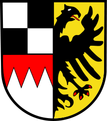 Coat of Arms of Middle Franconia
The coat of arms displays: - the black and white pattern of the Hohenzollern family in the upper dexter quarter (the first quarter)[2]
- the Arms of Franconia in the lower dexter quarter (the 3rd quarter)[3]
- the sinister half of the German Imperial Eagle (similar to that displayed by the German Confederation) in the sinister half.[4]
Population
Year Inhabitants 1900 815,895 1910 930,868 1939 1,065,122 1950 1,273,030 1961 1,371,144 1970 1,486,389 1987 1,521,484 2002 1,703,869 2005 1,712,275 2006 1,712,622 2008 1,714,453 2010 1,710,876 See also
- Upper Franconia (Oberfranken)
- Lower Franconia (Unterfranken)
References
- ^ "Fortschreibung des Bevölkerungsstandes" (in German). Bayerisches Landesamt für Statistik und Datenverarbeitung. 31 December 2010. https://www.statistikdaten.bayern.de/genesis/online?language=de&sequenz=tabelleErgebnis&selectionname=12411-009r&sachmerkmal=QUASTI&sachschluessel=SQUART04&startjahr=2010&endjahr=2010.
- ^ http://en.wikipedia.org/wiki/County_of_Hohenzollern
- ^ http://en.wikipedia.org/wiki/Franconia
- ^ http://en.wikipedia.org/wiki/File:Wappen_Deutscher_Bund.svg
External links
 Upper Bavaria • Lower Bavaria • Upper Palatinate • Upper Franconia • Middle Franconia • Lower Franconia • Swabia
 Categories:
- Government regions of Germany
- Middle Franconia
- NUTS 2 statistical regions of the European Union
- Wine regions of Germany


Wikimedia Foundation. 2010.