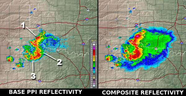
Composite reflectivity

Composite reflectivity
#1 the fuchsia colored region, visible on the composite image, is all but missing on the base reflectivity
#2 and #3, show more rain supported by strong updrafts.

The composite reflectivity is the maximum dBZ reflectivity from any of the reflectivity angles of the NEXRAD weather radar[1]. The reflectivity on individual PPI angles show the precipitation intensity at that specific angle above the horizon. Some of these angles are .5,1.45,2.4, and 3.35 degrees with the Doppler radar having up to 14 angles when it's in Severe Mode. In the Composite, the highest intensities amongst those available in the different angles above each point of the image will be displayed . In the Canadian weather radar network, this is called MAXR, for Maximum reflectivity in the column.


Use

When compared to the base angle reflectivity, the lowest angle of elevation sounding, the composite reflectivity, including higher elevation scan information, may appear to indicate more widespread rain. This could indicate one of two things :

  • Virga : the precipitation (rain or snow) is probably not reaching the ground but evaporating as it falls from very high in the atmosphere. This is a regular situation in winter as snowflakes can easily sublimate in dry air near the ground.
  • Strong updrafts : air rising in a thunderstorm updraft will saturate at higher level than the rest of the cloud forming an overhang region. In case of a very strong updraft, a Bounded weak echo region (BWER) will form and lead to the possibility of severe weather.

External links

References

  1. ^ National Weather Service (August 29, 2007). "Composite Reflectivity". JetStream - Online School for Weather. NOAA. http://www.srh.noaa.gov/jetstream/doppler/comprefl.htm. Retrieved 2008-10-03. 

Wikimedia Foundation. 2010.

Игры ⚽ Поможем написать курсовую

Look at other dictionaries:

  • Weather radar — in Norman, Oklahoma with rainshaft …   Wikipedia

  • Lightning prediction system — A lightning prediction system includes various methods and different apparatus for remotely sensing electrical activity and the potential for lightning occurrence. In the several variant systems and methods, means are provided for the automated… …   Wikipedia

  • Refractive index — Refraction of light at the interface between two media. In optics the refractive index or index of refraction of a substance or medium is a measure of the speed of light in that medium. It is expressed as a ratio of the speed of light in vacuum… …   Wikipedia

  • climate — /kluy mit/, n. 1. the composite or generally prevailing weather conditions of a region, as temperature, air pressure, humidity, precipitation, sunshine, cloudiness, and winds, throughout the year, averaged over a series of years. 2. a region or… …   Universalium

  • Schmidt-Pechan prism — A Schmidt Pechan prism is a type of optical prism used to rotate an image by 180°. They are commonly used in binoculars as an image erecting system . Compared to binoculars using a Porro prism or Abbe Koenig a binoculars using a Schmidt Pechan… …   Wikipedia

  • Mathematics and Physical Sciences — ▪ 2003 Introduction Mathematics       Mathematics in 2002 was marked by two discoveries in number theory. The first may have practical implications; the second satisfied a 150 year old curiosity.       Computer scientist Manindra Agrawal of the… …   Universalium

  • Optics — For the book by Sir Isaac Newton, see Opticks. Optical redirects here. For the musical artist, see Optical (artist). Optics includes study of dispersion of light. Optics is the branch of …   Wikipedia

  • Optical disc recording technologies — Optical discs Optical disc Optical disc drive Optical disc authoring Authoring software Recording technologies Recording modes Packet writing Optical media types …   Wikipedia

  • Potrillo volcanic field — The Potrillo Volcanic Field is a monogenetic volcanic field located on the Rio Grande Rift in New Mexico, USA and Chihuahua, Mexico. It lies convert|35|km|mi|0 west of El Paso, Texas. Rio Grande Rift *Rifting began in Late Oligocene cite book |… …   Wikipedia

  • Superior craton — in the west. The western margin extends from northern Minnesota through eastern Manitoba to northwestern Ontario.The formation of the Superior craton is best explained within the context of 2.72 2.68 Ga accretion of small continental plates and… …   Wikipedia

Share the article and excerpts

Direct link
Do a right-click on the link above
and select “Copy Link”