- Bounded weak echo region
-
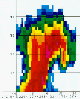
 Vertical cross-section through a supercell showing the BWER.
The bounded weak echo region, also known as a BWER or a vault, is a radar signature within a thunderstorm characterized by a local minimum in radar reflectivity at low levels which extends upward into, and is surrounded by, higher reflectivities aloft. This feature is associated with a strong updraft and is almost always found in the inflow region of a thunderstorm. It cannot be seen visually.[1] The BWER has been noted on radar imagery of severe thunderstorms since 1973 and has a lightning detection system equivalent known as a lightning hole.[2]
Contents
Description and attributes
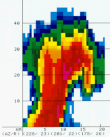
 BWER associated with a tornadic supercell in 2006, as seen from different elevation angles. The lower angles (upper left) shows a weaker area of reflectivity but not at higher levels.
The BWER is a nearly vertical channel of weak radar echo, surrounded on the sides and top by significantly stronger echoes. The BWER, sometimes called a vault, is related to the strong updraft in a severe convective storm that carries newly formed atmospheric particulates, called hydrometeors, to high levels before they can grow to radar-detectable sizes. BWERs are typically found at midlevels of convective storms, 3 kilometres (1.9 mi) to 10 kilometres (6.2 mi) above the ground, and are a few kilometers in horizontal diameter.[3] Identifying the location of the updraft region is important because it is linked to locations where severe weather normally occurs.[4] The presence of a BWER has been part of a method to diagnose thunderstorm strength as part of the Lemon technique since 1977.[5] The updraft strength within the BWER supports the growth of large hailstones just above the vault, which can be displaced slightly into the direction of motion of the parent supercell storm.[6]
Detection
See also: Weather radarThe bounded weak echo region (BWER) is a region of low radar reflectivity bounded above by an area of higher radar reflectivity which shows evidence of a strong updraft within mesocyclones. Radar analysts have recognized this phenomenon since at least 1973,[7] using different elevation scans. Methods of objectively corroborating that a BWER is associated with a mesocyclone is done by using a weather radar with Doppler effect to obtain the precipitations velocities. This have been available operationally in United States since 1997 with the NEXRAD network.[8] When using the lightning detection system, lightning holes (uncovered in 2004) correspond to where a BWER would be seen on radar.[2]
A cross-section of the three-dimensional reflectivity of a thunderstorm shows the vault better. Algorithms were developed by the J.S. Marshall Radar Observatory of McGill University in Canada to locate the overhang region in a thunderstorm by the late 1980s.[9][10][11][12] Its radar uses 24 angles, giving it good vertical resolution.[13] In United States, fewer scanning angles are made within the WSR-88D radar which makes it more difficult to detect the overhang.[14][15] Once the overhang is located, it is possible to make a cross-section to view if it is related with a BWER.[16] However, since 1997 algorithms have been developed by the National Weather Service to determine regions of reflectivity gradient in three dimensions and the presence of BWER in convection.[17]
The development of a pronounced BWER can lead to tropical cyclone-like radar signatures over land when located with a low angle plan position indicator (PPI).[18][19] When using the lightning detection system, lightning holes (uncovered in 2004) correspond to where a BWER would be seen on radar.[2]
See also
References
- ^ National Weather Service. "Bounded Weak Echo Region". Meteorological Glossary. National Oceanic and Atmospheric Administration. http://www.weather.gov/glossary/index.php?letter=b. Retrieved 2008-02-08.
- ^ a b c Martin J. Murphy and Nicholas W. S. Demetriades. An Analysis of Lightning Holes in a DFW Supercell Storm Using Total Lightning and Radar Information. Retrieved on 2008-01-08.
- ^ "Bounded Weak Echo Region". Meteorological Glossary. American Meteorological Society. http://amsglossary.allenpress.com/glossary/search?id=bounded-weak-echo-region1. Retrieved 2008-02-08.
- ^ Advanced Warning Operations Course. IC 3-I-B: 1. Storm Interrogation. Retrieved on 2008-01-08.
- ^ Leslie R. Lemon. New severe thunderstorm radar identification techniques and warning criteria: a preliminary report. Techniques Development Unit, National Severe Storms Forecast Center, Kansas City, Missouri, July 1977.
- ^ William R. Cotton and Roger A. Pielke. Human Impacts on Weather and Climate. Retrieved on 2008-01-08.
- ^ Richard Jason Lynn. The WDSS-II Supercell Identification and Assessment Algorithm. Retrieved on 2008-01-08
- ^ Kenneth Falk and William Parker. ROTATIONAL SHEAR NOMOGRAM FOR TORNADOES. Retrieved on 2008-03-08. Archived August 21, 2005 at the Wayback Machine
- ^ Frédéric Fabry (2007-08-14). "McGill S-band radar severe weather algorithms". McGill University. Wayback Machine. Archived from the original on 2007-08-14. http://web.archive.org/web/20070814192806/http://www.radar.mcgill.ca/severe_weather.html. Retrieved 2010-06-14.
- ^ Duncan, M.R.; A. Bellon, A. Kilambi, G.L. Austin, and H.P. Biron (1992). "PPS and PPS jr: A distribution network for weather radar products, severe warnings and rainfall forecasts.". Preprint. 8th International Conf. on interactive information and processing systems for Meteorology, Oceanography and Hydrology,. Atlanta, Georgia. pp. 67–74.
- ^ Austin, G.L.; A. Kilambi, A. Bellon, N. Leoutsarakos, A. Hausner, L. Trueman, and M. Ivanich (1986). "Rapid II: An operational, high speed interactive analysis and display system for intensity radar data processing". In American Meteorological Society. Preprint. 23rd Conf. on Radar Meteor. & Conf. on Cloud Physics. Snowmass, Colorado. pp. 79–82.
- ^ Halle, J.; A. Bellon (1980). "Operational use of digital radar products at the Quebec Weather Centre of the Atmospheric Environment Service, Canada". In American Meteorological Society. Preprint. 19 th Radar Meteor. Conf.. Miami, Florida. pp. 72–73.
- ^ Frédéric Fabry. "McGill S-band radar characteristics". McGill University. http://www.radar.mcgill.ca/facilities/mcgill-radar.html. Retrieved 2010-06-14.
- ^ Advanced Warning Operations Course. 1. Storm Interrogation. Retrieved on 2008-03-08.
- ^ Rhonda Scott, Randy M. Steadham, and Rodger A. Brown. New Scanning Strategies for the WSR-88D. Retrieved on 2008-03-08.
- ^ Leslie R. Lemmon. The Radar “Three-Body Scatter Spike”: An Operational Large-Hail Signature. Retrieved on 2008-03-08.
- ^ Valliappa Lakshmanan. The Bounded Weak Echo Region Algorithm. Retrieved on 2008-01-08.
- ^ Storm Prediction Center. North Carolina "Tornadocane" from 1999. Retrieved on 2008-01-08.
- ^ David M. Roth. MCS with Eye - July 21, 2003. Retrieved on 2008-01-08.
External links
Categories:- Tropical cyclone meteorology
- Severe weather and convection
- Radar meteorology

Wikimedia Foundation. 2010.