- Mongaguá
-
City of Mongaguá 
Flag
SealLocation in the state of São Paulo and the country of Brazil.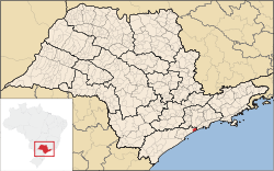
Coordinates: 24°05′15.3″S 46°37′44″W / 24.087583°S 46.62889°WCoordinates: 24°05′15.3″S 46°37′44″W / 24.087583°S 46.62889°W Country Brazil State São Paulo Government – Mayor Artur Parada Prócida Area – Total 143.171 km2 (55.3 sq mi) – Land 290.3 km2 (112.1 sq mi) Elevation 8 m (26 ft) Population (2006) – Total 46,977 Time zone Brasília time (UTC-2) Website Página da prefeitura Mongaguá is a municipality in the state of São Paulo in Brazil. The population in 2006 is 46,977, the population density is 328.11/km² and the area is 143 km². The name comes from the Tupi language.
The municipality's street plan is on a planned grid running from SSE to NNW and many of the houses are within sight of the Atlantic Ocean. The populated area of Mongaguá is near the bottom of steep-sloping and densely-forested mountains. The BR-101 superhighway linking Santos and the southern part of the state runs through Mongaguá. The freeway to the city of São Paulo is also easily accessible. Housing developments near the beaches were built in the 1970s and the 1990s. Prior to the construction of the housing developments, the population was mainly rural. Housing development continues to this day.
There are two aboriginal villages in Mongaguá: Itaóca and Aguapéu, located in the Atlantic Mata reserve. The aboriginal community of Aguapéu conceived of the project Jaguatareí Nhemboé (Walking and Learning).
Population history
Year Population Density 2004 43,384 303.38/km² 2006 46,977 328.11/km² External links
- (Portuguese) http://www.mongagua.sp.gov.br
- (Portuguese) citybrazil.com.br
- (Portuguese) Portal Nosso São Paulo
North: Praia Grande, São Paulo and São Vicente West: Itanhaém Mongaguá East: Atlantic Ocean, São Vicente and Praia Grande South: Atlantic Ocean Categories:- Baixada Santista
- Populated coastal places in São Paulo (state)
- São Paulo (state) geography stubs


Wikimedia Foundation. 2010.