- Dyer (Amtrak station)
-
Dyer 
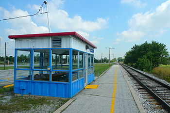
The Amtrak shelter station at Dyer, looking "railroad west" (compass northwest) towards Chicago.Station statistics Address 913 Sheffield Avenue
Dyer, IN 46311Coordinates 41°30′55″N 87°31′05″W / 41.5154°N 87.5181°WCoordinates: 41°30′55″N 87°31′05″W / 41.5154°N 87.5181°W Lines CardinalHoosier StateConnections EasyGo Lake Transit Other information Code DYE Traffic Passengers (FY2010) 2,257[1]  2.9% (Amtrak)
Services Preceding station Amtrak Following station TerminusCardinal toward New York CityHoosier State toward IndianapolisDyer is an Amtrak station in Dyer, Indiana, served by the Cardinal and Hoosier State, and is the penultimate station for both trains.
Dyer Station is merely a sheltered platform and a little shelter with just seats, however it is located near an at-grade crossing of two railroad lines; CSX (formerly the Monon Railroad) and the Elgin, Joliet & Eastern. [2] The original depot stood at the diamond junction itself.[3]
The Northern Indiana Commuter Transportation District (NICTD) has proposed a line to Lowell, Indiana using Dyer as a stop. However, the station is intended to be south of both the existing station and the CSX/EJ&E crossing at U.S. 30.[4]
Of the 11 Indiana stations served by Amtrak, Dyer was the ninth-busiest in FY2010, boarding or detraining an average of approximately 6 passengers daily.[5]
Contents
Connections
On August 2, 2010, Northwest Indiana Regional Bus Authority revamped the Hammond Transit System into EasyGo Lake Transit. The newly introduced Red Route terminates approximately a mile northeast of the station, at Main/Calumet intersection. Riders can take the Red Route to Munster, Hammond and Chicago's East Side neighborhood. They can also transfer to other EasyGo routes and connect to other towns and cities throughout Lake Country.
Notes
- ^ "Amtrak Fact Sheet, FY2010, State of Indiana" (PDF). Amtrak. November 2010. http://www.amtrak.com/pdf/factsheets/INDIANA10.pdf. Retrieved 2011-1-6.
- ^ Crossing CSX and EJ&E; August 28, 2001 (TrainWeb)
- ^ Longest (2007), 93.
- ^ West Lake Corridor Study (NICTD)
- ^ "Amtrak Fact Sheet, FY2010, State of Indiana" (PDF). Amtrak. November 2010. http://www.amtrak.com/pdf/factsheets/INDIANA10.pdf. Retrieved 2011-1-6.
References
- Longest, David E. (2007). Railroad Depots of Northern Indiana. Arcadia Publishing. ISBN 0738541311. http://books.google.com/books?id=5Won-pAJo7AC.
External links
Categories:- Amtrak stations in Indiana
- Chicago, Indianapolis and Louisville Railway
- Buildings and structures in Lake County, Indiana
- Transportation in Lake County, Indiana
- Midwestern United States railway station stubs
- Indiana building and structure stubs
Wikimedia Foundation. 2010.
