- Mount Hagen (volcano)
-
This article is about the volcano. For the city named after the volcano, see Mount Hagen.
Mount Hagen 
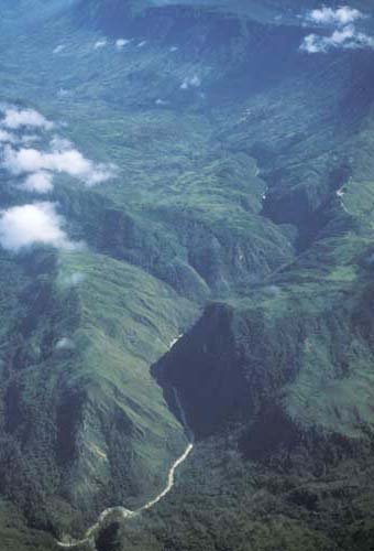
Elevation 3,778 m (12,395 ft) [citation needed] Prominence >900 m (3,000 ft)[citation needed] Location Location Western Highlands and Enga Provinces, Papua New Guinea Range Hagen Range Coordinates 5°45′S 144°2′E / 5.75°S 144.033°E[1] Geology Type Eroded stratovolcano Age of rock 210,000–380,000 years[2] Last eruption ~ 210,000 years ago Mount Hagen (German: Hagensberg), named after the German colonial officer Curt von Hagen, is the second highest volcano in Papua New Guinea and on the Australian continent, ranking behind only its neighbour Mount Giluwe which is roughly 35 kilometres (22 mi) to the southwest. It is located on the border between the Western Highlands and Enga Provinces, about 24 kilometres (15 mi) northwest of the city of Mount Hagen which is named after it.
Mount Hagen is an old stratovolcano which has been heavily eroded during several Pleistocene glaciations. The maximum extent of the glaciers on Hagen was less than half that on the much higher Mount Giluwe, covering an area of up to 50 km² (20 mi²) and extending down below 3,400 m (11,000 ft).[3]
Notes
- ^ "Hagen, Mount". GEOnet Names Server. http://geonames.nga.mil/ggmagaz/detaillinksearch.asp?G_NAME=%2732FA882130393774E0440003BA962ED3%27&Diacritics=DC. Retrieved 2011-05-17.
- ^ Löffler, E.; D. E. Mackenzie and A. W. Webb (1980). "Potassium-argon ages from some of the Papua New Guinea highlands volcanoes, and their relevance to Pleistocene geomorphic history". Journal of the Geological Society of Australia 26 (7–8): 387–397.
- ^ Mackenzie, D. E. (1985). "Giluwe and Hagen; glaciated volcanoes in the rain forests of western PNG". Volcano News 19–20: 7.
See also
External links
- Mount Hagen on Peakware
 Categories:
- Stratovolcanoes
- Volcanoes of Papua New Guinea
- Mountains of Papua New Guinea
- Hiking in Papua New Guinea
- Enga Province
- Western Highlands Province
- Papua New Guinea geography stubs
Wikimedia Foundation. 2010.