Mount Tahan

Mount Tahan
Mount Tahan
Gunung Tahan
ڬونوڠ تاهن

Gunung Tahan
Elevation 2,187 m (7,175 ft)
Location
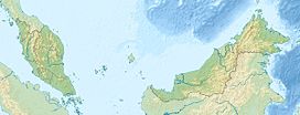
Mount Tahan is located in Malaysia
Mount Tahan
Taman Negara National Park, Pahang,  Malaysia
Range Tahan Range
Coordinates 4°38′N 102°14′E / 4.633°N 102.233°E / 4.633; 102.233Coordinates: 4°38′N 102°14′E / 4.633°N 102.233°E / 4.633; 102.233

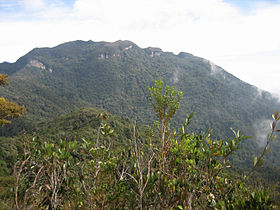
Mount Tahan (Malay: Gunung Tahan), at 2,187 m, is the highest point in Peninsular Malaysia. It is located within the Taman Negara national forest, in the state of Pahang. The mountain is part of the Tahan Range and popular to local climbers.

In Malay language, "gunung" means "mountain" and "tahan" means "endure". Thus the name of the mountain suggests that a certain level of physical endurance is required to conquer the mountain. Gunung Tahan is considered by many to be one of the toughest treks in Peninsular Malaysia.

Contents

Trails

The Kuala Tahan classic trail is the oldest and most scenic trail. A return trip on this trail typically takes seven days. Climbers have to trek across undulating ridges and make several river crossings before finally reaching the foot of the mountain to make the final ascent.

Climbers without adequate physical fitness or training are not advised to attempt Gunung Tahan.

The other two trails are Merapoh (Sungai Relau) and via Kelantan. Both are significantly shorter than the classic trail from Kuala Tahan. A return trip on the Merapoh trail takes 3–4 days. A traverse from Kuala Tahan to Merapoh (or the other way around) takes around 5 days.

Gallery

See also

External links


Wikimedia Foundation. 2010.

Игры ⚽ Поможем написать курсовую

Look at other dictionaries:

  • Mount Korbu — Gunung Korbu Elevation 2,183 m (7,162 ft) …   Wikipedia

  • Tahan, Mount — ▪ mountain, Malaysia Malay  Gunung Tahan        highest peak of the Malay Peninsula (7,175 feet [2,187 m]), in the Tahan Range, West Malaysia. Mount Tahan is the central feature of Taman Negara National Park and a destination for mountaineers who …   Universalium

  • Geography of Malaysia — Continent Asia Region Southeast Asia Coordinates 2°30 N 112°30 E Area Ranked 67th 329,847 km2 …   Wikipedia

  • Nepenthes gracillima — An upper pitcher of N. gracillima from the upper slopes of Mount Tahan Conservation status …   Wikipedia

  • Ishak Haji Muhammad — (14 November 1909 7 November 1991) or better known as Pak Sako was a prominent Malaysian writer, active in the 1930s until the 1950s. He was a nationalist and his involvement began before independence and continued thereafter. He fought for the… …   Wikipedia

  • Malay Peninsula — a peninsula in SE Asia, consisting of W (mainland) Malaysia and the S part of Thailand. Also called Malaya. * * * Peninsula, Southeast Asia. Comprising the mainland portion of Malaysia and southwestern Thailand, it occupies an area of 70,000 sq… …   Universalium

  • Nepenthes benstonei — Upper pitchers of Nepenthes benstonei from Bukit Bakar Scientific classification Kingdom: Pl …   Wikipedia

  • Pahang River — Infobox River | river name = Pahang River Sungai Pahang caption = origin = Titiwangsa Mountains mouth = Kuala Pahang basin countries = Pahang, Malaysia length = 459 km elevation = m discharge = m³/s watershed =Pahang River or ( Sungai Pahang in… …   Wikipedia

  • Nepenthes alba — An unusually reddish upper pitcher of N. alba growing on Mount Tahan Scientific classification Kingdom …   Wikipedia

  • Main Range — ▪ mountains, Malaysia also called  Central Range , or  Buffalo Range        mountain range in West Malaysia, the most prominent mountain group on the Malay Peninsula. Composed of granite with some patches of altered stratified rocks, the range… …   Universalium

Share the article and excerpts

Direct link
Do a right-click on the link above
and select “Copy Link”