- Müritz
-
Müritz 
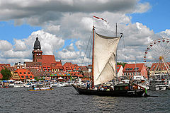
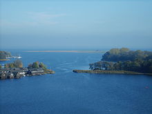
Waren harbour during the Müritz Sail Location Mecklenburgische Seenplatte, Mecklenburg-Vorpommern Coordinates 53°25′N 12°41′E / 53.417°N 12.683°ECoordinates: 53°25′N 12°41′E / 53.417°N 12.683°E Lake type mesotrophic Primary inflows Elde Primary outflows Elde Catchment area 663 km² (255.9 miles²) Basin countries Germany Surface area 117 km² Average depth 6 m (19.6 feet) Max. depth 31 m (101.7 feet) Residence time 15 years (?) Surface elevation 62 m (203 feet) Settlements Waren, Röbel  Lake Müritz in Röbel
The
 Müritz (help·info) (from slavic "little sea") is a lake in Mecklenburg-Vorpommern, northern Germany. Its area is 117 km², which makes it the second largest lake of Germany (after Lake Constance). Its maximum depth is 31 metres. It is fed and drained by the river Elde. Part of the Müritz and adjacent forests and wetlands are protected by the Müritz National Park. The former Müritz district was named after the lake. The biggest towns bordering the lake are Waren (Müritz) and Röbel, both major centers of tourism in the Mecklenburg Lake District.
External links
 Media related to Müritz at Wikimedia Commons
- Nixdorf, B.; et al. (2004), "Müritz" (in German), Dokumentation von Zustand und Entwicklung der wichtigsten Seen Deutschlands, Berlin: Umweltbundesamt, pp. 191, http://www-docs.tu-cottbus.de/gewaesserschutz/public/projekte/uba_2/02_meck_pom.pdf#page=191
- Müritz-Nationalpark
- Müritzeum - Nature Discovery Center in Waren
- Official website of Waren (Müritz)
- Official website of Röbel (Müritz)
Categories:- Lakes of Mecklenburg-Vorpommern
- Mecklenburgische Seenplatte (district) geography stubs
Wikimedia Foundation. 2010.
