Mecklenburgische Seenplatte (district)
- Mecklenburgische Seenplatte (district)
-
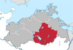
Mecklenburgische Seenplatte is a district in the southeast of Mecklenburg-Vorpommern, Germany. It is bounded by (from the west and clockwise) the districts Ludwigslust-Parchim, Rostock (district), Vorpommern-Rügen, Vorpommern-Greifswald, and the state Brandenburg to the south. The district seat is the town Neubrandenburg.[2]
History
The district was established by merging the former districts of Müritz, Mecklenburg-Strelitz and Demmin (except the Ämter Jarmen-Tutow and Peenetal/Loitz) and the former district-free town Neubrandenburg as part of the local government reform of September 2011.[2] The name of the district was decided by referendum on 4 September 2011.[3]
Towns and municipalities
| Ämter |
- Beggerow
- Borrentin
- Hohenbollentin
- Hohenmocker
- Kentzlin
- Kletzin
- Lindenberg
- Meesiger
- Nossendorf
- Sarow
- Schönfeld
- Siedenbrünzow
- Sommersdorf
- Utzedel
- Verchen
- Warrenzin
- Datzetal
- Eichhorst
- Friedland1, 2
- Galenbeck
- Genzkow
- Glienke
- Basedow
- Duckow
- Faulenrost
- Gielow
- Kummerow
- Malchin1, 2
- Neukalen2
- Alt Schwerin
- Fünfseen
- Göhren-Lebbin
- Malchow1, 2
- Nossentiner Hütte
- Penkow
- Silz
- Walow
- Zislow
- Mirow1, 2
- Priepert
- Roggentin
- Wesenberg2
- Wustrow
|
- Blankensee
- Blumenholz
- Carpin
- Godendorf
- Grünow
- Hohenzieritz
- Klein Vielen
- Kratzeburg
- Möllenbeck
- Userin
- Wokuhl-Dabelow
- Beseritz
- Blankenhof
- Brunn
- Neddemin
- Neuenkirchen
- Neverin1
- Sponholz
- Staven
- Trollenhagen
- Woggersin
- Wulkenzin
- Zirzow
- Ankershagen
- Krukow
- Lapitz
- Mallin
- Möllenhagen
- Penzlin1, 2
- Puchow
- Altenhof
- Bollewick
- Buchholz
- Bütow
- Fincken
- Gotthun
- Grabow-Below
- Groß Kelle
- Kieve
- Lärz
- Leizen
- Ludorf
- Massow
- Melz
- Priborn
- Rechlin
- Röbel1, 2
- Schwarz
- Sietow
- Stuer
- Vipperow
- Wredenhagen
- Zepkow
|
- Grabowhöfe
- Groß Dratow
- Groß Gievitz
- Groß Plasten
- Hinrichshagen
- Hohen Wangelin
- Jabel
- Kargow
- Klink
- Klocksin
- Lansen-Schönau
- Moltzow
- Neu Gaarz
- Schloen
- Schwinkendorf
- Torgelow am See
- Varchentin
- Vielist
- Vollrathsruhe
- Burg Stargard1, 2
- Cammin
- Cölpin
- Groß Nemerow
- Holldorf
- Lindetal
- Pragsdorf
- Teschendorf
- Bredenfelde
- Briggow
- Grammentin
- Gülzow
- Ivenack
- Jürgenstorf
- Kittendorf
- Knorrendorf
- Mölln
- Ritzerow
- Rosenow
- Stavenhagen1, 2
- Zettemin
|
- Altenhagen
- Altentreptow1, 2
- Bartow
- Breesen
- Breest
- Burow
- Gnevkow
- Golchen
- Grapzow
- Grischow
- Groß Teetzleben
- Gültz
- Kriesow
- Pripsleben
- Röckwitz
- Siedenbollentin
- Tützpatz
- Werder
- Wildberg
- Wolde
- Groß Miltzow
- Helpt
- Kublank
- Mildenitz
- Neetzka
- Petersdorf
- Schönbeck
- Schönhausen
- Voigtsdorf
- Woldegk1, 2
|
| 1seat of the Amt; 2town |
References
- ^ "Bevölkerungsentwicklung der Kreise und Gemeinden" (in German). Statistisches Amt Mecklenburg-Vorpommern. 31 December 2010. http://service.mvnet.de/statmv/daten_stam_berichte/e-bibointerth01/bevoelkerung--haushalte--familien--flaeche/a-i__/a123__/2010/daten/a123-2010-22.pdf.
- ^ a b "Mecklenburg-Vorpommern government reform". http://www.mv-regierung.de/im/verwaltungsreform/. Retrieved 5 September 2011.
- ^ "Referendum results Mecklenburgische Seenplatte". http://service.mvnet.de/cgi-bin/wahlen/2011_kom_land/wahl2011_anz.pl?Kreisnamenentscheid_71.htm. Retrieved 5 September 2011.
v · Urban and rural districts in the state of Mecklenburg-Vorpommern in Germany  |
|
| Urban districts |
|
 |
|
| Rural districts |
Ludwigslust-Parchim · Mecklenburgische Seenplatte · Nordwestmecklenburg · Rostock · Vorpommern-Greifswald · Vorpommern-Rügen |
|
Coordinates: 53°30′N 13°05′E / 53.5°N 13.083°E / 53.5; 13.083
Categories:
- Districts of Mecklenburg-Vorpommern
- Mecklenburgische Seenplatte (district) geography stubs
Wikimedia Foundation.
2010.
Look at other dictionaries:
Mecklenburgische Kleinseenplatte — is an Amt in the Mecklenburgische Seenplatte district, in Mecklenburg Vorpommern, Germany. The seat of the Amt is in Mirow. The Amt Mecklenburgische Kleinseenplatte consists of the following municipalities: Mirow Priepert Roggentin Wesenberg… … Wikipedia
Mecklenburgische Schweiz — is an Amt in the district of Rostock, in Mecklenburg Vorpommern, Germany. The seat of the Amt is in Teterow, itself not part of the Amt. The Amt Mecklenburgische Schweiz consists of the following municipalities: Alt Sührkow Dahmen Dalkendorf Groß … Wikipedia
Mecklenburg Lake District — Mecklenburg Lakes area after sunset from about 8 km height Mecklenburgische Seenplatte redirects here. For the administrative district, see Mecklenburgische Seenplatte (district). The Mecklenburg Lake District[1] (German: Mecklenburgische… … Wikipedia
Müritz (district) — Müritz District Country … Wikipedia
Mecklenburg-Strelitz (district) — Mecklenburg Strelitz District Country … Wikipedia
Demmin (district) — Demmin District Country … Wikipedia
Mirow — For Polish place names, see Mirów (disambiguation). Mirow … Wikipedia
Malchow — For other uses, see Malchow (disambiguation). Malchow Windmill in Malchow … Wikipedia
Malchin — Brick Gothic town gate of Malchin (Kalensches Tor) … Wikipedia
Dargun — Model of Dargun Abbey and Castle before destruction in WW2 … Wikipedia
 Germany