- Chūgoku Mountains
-
Chūgoku Mountains (中国山地 Chūgoku Sanchi) Range 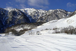
Name origin: central country Country Japan States Hyōgo, Hiroshima, Okayama, Shimane, Tottori, Yamaguchi Region Chūgoku Range Chūgoku Highest point Daisen - elevation 1,729 m (5,673 ft) - coordinates 35°22′16″N 133°32′47″E / 35.37111°N 133.54639°E Chūgoku Mountains (中国山地 Chūgoku Sanchi) is a mountain range in the Chūgoku region of western Japan. It runs in an east-west direction and stretches approximately 500 km (311 mi) from Hyōgo Prefecture in the east to the coast of Yamaguchi Prefecture. It also reaches under the Pacific Ocean.
The two tallest mountains in the group are Daisen and Mount Hyōno, which are 1,729 m (5,673 ft) and 1,510 m (4,954 ft), respectively. Many other mountains in the ranger are also over 1,000 m (3,281 ft), while some of the smaller mountains are less than 500 m (1,640 ft). Granite is the most common stone found among the mountains, much of which has been exposed through erosion.
Geography
Other than Daisen, most of the mountains run along the border of Tottori and Okayama prefectures and the border of Shimane and Hiroshima prefectures. The mountains essentially divide the San'in region north of the mountains from the San'yō region in the south.
Major mountains
- Mount Daisen(大山), 1,729 m (5,673 ft)
- Mount Hyōno(氷ノ山), 1,510 m (4,954 ft)
- Mount Mimuro (三室山), 1,358 m (4,455 ft)
- Mount Osorakan (恐羅漢山), 1,346 m (4,416 ft)
- Mount Ushiro (後山), 1,345 m (4,413 ft)
- Mount Kanmuri (冠山), 1,339 m (4,393 ft)
- Mount Jakuchi (寂地山), 1,337 m (4,386 ft)
- Mount Ōgi (扇ノ山), 1,310 m (4,298 ft)
- Mount Dōgo (道後山), 1,268 m (4,160 ft)
- Mount Hiba (比婆山), 1,264 m (4,147 ft)
- Mount Nagi (那岐山), 1,255 m (4,117 ft)
- Mount Hiru (蒜山), 1,199 m (3,934 ft)
- Mount Myōken (妙見山), 1,136 m (3,727 ft)
- Mount Ōsa (大佐山), 1,069 m (3,507 ft)
- Mount Sen (千ヶ峰), 1,005 m (3,297 ft)
- Mount Hōbutsu (宝仏山), 1,005 m (3,297 ft)
- Mount Seppiko (雪彦山), 915 m (3,002 ft)
- Mount Aono (青野山), 907 m (2,976 ft)
- Mount Haku (白山), 510 m (1,673 ft)
Categories:- Mountain ranges of Japan
- Visitor attractions in Hyōgo Prefecture
- Visitor attractions in Okayama Prefecture
- Visitor attractions in Hiroshima Prefecture
- Visitor attractions in Shimane Prefecture
- Visitor attractions in Tottori Prefecture
- Visitor attractions in Yamaguchi Prefecture
- Mountains of Hyōgo Prefecture
- Mountains of Okayama Prefecture
- Mountains of Hiroshima Prefecture
- Mountains of Shimane Prefecture
- Mountains of Tottori Prefecture
- Mountains of Yamaguchi Prefecture
- Hyōgo geography stubs
- Hiroshima geography stubs
- Okayama geography stubs
- Shimane geography stubs
- Tottori geography stubs
- Yamaguchi geography stubs

Wikimedia Foundation. 2010.