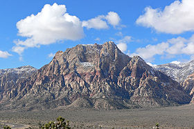
- Mount Wilson (Nevada)
-
Mount Wilson 
Elevation 7,071 ft (2,155 m) [1] Location Location Clark County, Nevada, USA Range Spring Mountains [2] Coordinates 36°05′37.1″N 115°29′02.3″W / 36.093639°N 115.483972°WCoordinates: 36°05′37.1″N 115°29′02.3″W / 36.093639°N 115.483972°W[1] Topo map USGS Blue Diamond Climbing Easiest route Scramble Mount Wilson is the second highest peak in the Red Rock Canyon National Conservation Area, in the Spring Mountains.
Mount Wilson in Clark County of southern Nevada.
References
- ^ a b "Wilson". NGS data sheet. U.S. National Geodetic Survey. http://www.ngs.noaa.gov/cgi-bin/ds_mark.prl?PidBox=GR1809. Retrieved 2008-11-27.
- ^ "Mount Wilson, Nevada". Peakbagger.com. http://www.peakbagger.com/peak.aspx?pid=21575. Retrieved 2011-05-19.
External links
- "Mount Wilson". Geographic Names Information System, U.S. Geological Survey. http://geonames.usgs.gov/pls/gnispublic/f?p=gnispq:3:::NO::P3_FID:844985. Retrieved 2008-11-27.
Categories:- Spring Mountains
- Climbing areas of the United States
- Mountains of Nevada
- Protected areas of the Mojave Desert
- Landforms of Clark County, Nevada
- Nevada geography stubs
Wikimedia Foundation. 2010.
