- Haparanda
Infobox Settlement
official_name = Haparanda
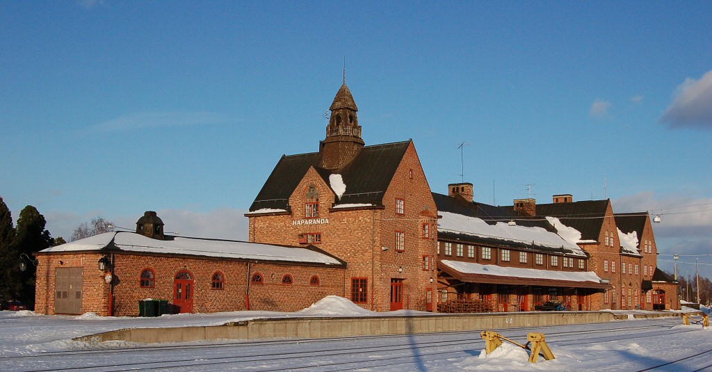
image_caption = Haparanda railway station
image_shield =
mapsize =
map_caption =
pushpin_
settlement_type = Town
subdivision_type = Country
subdivision_name =Sweden
subdivision_type1 = Municipality
subdivision_name1 =Haparanda Municipality
subdivision_type2 = County
subdivision_name2 =Norrbotten County
subdivision_type3 = Province
subdivision_name3 =Norrbotten
established_title3 =
established_date3 =
area_footnotes = cite web |title=Tätorternas landareal, folkmängd och invånare per km2 2000 och 2005 |publisher=Statistics Sweden |url=http://www.scb.se/statistik/MI/MI0810/2005A01B/T%E4torternami0810tab1.xls |format=xls |language=Swedish |accessdate=2008-05-15]
area_total_km2 = 3.97
population_as_of = 2005-12-31
population_footnotes =
population_total = 4,778
population_density_km2 = 1203
timezone = CET
utc_offset = +1
timezone_DST = CEST
utc_offset_DST = +2
latd=65 |latm=50 |lats= |latNS=N
longd=24 |longm=08 |longs= |longEW=E
website =Haparanda (Finnish: "Haaparanta", meaning "aspen" + "river bank") is a town in
Norrbotten , northernSweden , and the seat ofHaparanda Municipality ,Norrbotten County . It is adjacent toTornio ,Finland . Haparanda has a population of approximately 4,800 (and an area 3,94 km²) of out of a municipal total of 10,200 inhabitants.Haparanda is, despite its small population, for historical reasons often still referred to as a "city".
Statistics Sweden , however, only counts localities with more than 10,000 inhabitants as cities.The municipality itself, on the other hand, uses the term "Haparanda stad" (City of Haparanda) not only for the town itself, but for its whole territory (927 km²), a somewhat confusing usage.
History
When Sweden lost Finland in
1809 , the border was drawn along the Rivers Tornio andMuonio . The town ofTornio was on the Finnish side, thus becoming part of theGrand Duchy of Finland within theRussian Empire . (Finland declared independence in 1917).The Swedes started to develop a new town and Haparanda was made a market town ("
köping ") in1821 and received its city charter in1842 .The impact of the Border
The relationships between the neighbouring towns have however always been friendly. A large portion of Haparanda's population speak both Swedish and Finnish. Today the two towns are closely interconnected economically and socially; they constitute a transborder conurbation marketed as "EuroCity". As Sweden and Finland are on different
time zones , the time in Haparanda is one hour behind Tornio.Haparanda has a railway station, but it is no longer open for passenger trains. The station buildings were built to incoporate customs clearance facilities. During
World War I the only open route between Russia and Germany went here. DuringWorld War II approximately 80,000 Finnish children were evacuated to Sweden. Many arrived in Sweden by rail at Haparanda.The railway bridge between Haparanda and Tornio is the only direct crossing point between the Swedish and Finnish railways. The two networks have different track gauges, requiring all freight wagons crossing the border to have their bogies changed, or the cargo reloaded. There is
dual gauge track between Haparanda and Tornio.An
IKEA department store has been opened in the town on November 15, 2006 being the northernmost IKEA store in the world. Signage in the store is in both Swedish and Finnish, but prices are labelled inSwedish kronor . All shops in Haparanda accept euros.Haparanda has a few interesting buildings. A fine example is the quite famous needle-shaped watertower [http://upload.wikimedia.org/wikipedia/commons/thumb/8/89/Haparanda.jpg/347px-Haparanda.jpg] , which was built in 1920. The tower is no longer the towns provider of water, but it is still active as a heatingcenter, providing heat for Haparandas residents. The Haparanda church, built in 1967, was made to replace the previous church in Haparanda, which was destroyed in a fire in 1964.
References
Wikimedia Foundation. 2010.

