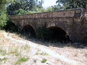
- Milliken Creek
-
Milliken Creek River Country United States State California Region Napa County Source Foss Valley - location 5 mi (8 km) east of Yountville - elevation 1,850 ft (564 m) [1] - coordinates 38°25′23″N 122°17′11″W / 38.42306°N 122.28639°W [1] Mouth Napa River - location Napa, California - elevation 10 ft (3 m) - coordinates 38°19′0″N 122°16′37″W / 38.316667°N 122.27694°W [1] Basin 11.3 sq mi (29 km2) [2] Milliken Creek is an 11.9-mile-long (19.2 km)[3] stream in Napa County, California that is tributary to the Napa River.[4] There are approximately 7,300 acres (3,000 ha) in this watershed, of which 90 acres (36 ha) are developed as vineyards.[2] Milliken Creek rises on the western slopes of the east side of the Napa Valley and flows through the Silverado Country Club property. Much of this watershed property had once been part of the Mexican land grant Rancho Yajome, which had been granted to General Mariano G. Vallejo. Most of this watershed was wilderness area to at least 1869, and thereafter the lower watershed was begun to be developed as pasture and grazing agricultural uses. In an 1989 stream survey by Earth Metrics, the steelhead fishery was found to be robust up to and including the Silverado Country Club.[5]
See also
References
- ^ a b c U.S. Geological Survey Geographic Names Information System: Milliken Creek
- ^ a b Napa Valley vineyard areas by watershed
- ^ U.S. Geological Survey. National Hydrography Dataset high-resolution flowline data. The National Map, accessed March 10, 2011
- ^ Napa Quadrangle, 7.5 Minute Series, U.S. Geological Survey, Government Printing Office, Washington DC
- ^ Earth Metrics Incorporated, "Phase I Environmental Site Assessment, Silverado Country Club, Napa County, California", May, 1989
External links
Categories:- Rivers of Napa County, California
- San Francisco Bay Area geography stubs
Wikimedia Foundation. 2010.

