- King George, Saskatoon
Infobox Settlement
official_name = King George
other_name =
native_name =
nickname =
settlement_type = Neighborhood
motto =
imagesize = 270px
image_caption = King George School
flag_size =
image_
seal_size =
image_shield =
shield_size =
city_logo =
citylogo_size =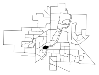
mapsize = 270px
map_caption = King George location map
mapsize1 =
map_caption1 =
image_dot_
dot_mapsize =
dot_map_caption =
dot_x = |dot_y =
pushpin_
pushpin_label_position =
pushpin_map_caption =
pushpin_mapsize =
subdivision_type = Country
subdivision_name = CAN
subdivision_type1 = Province
subdivision_name1 = SK
subdivision_type2 = City
subdivision_name2 = Saskatoon
subdivision_type3 = Suburban Development Area
subdivision_name3 = Core Neighbourhoods
subdivision_type4 = Neighbourhood
subdivision_name4 = King George
government_footnotes =
government_type = Municipal (Ward 2)
leader_title = Administrative body
leader_name =Saskatoon City Council
leader_title1 = Councillor
leader_name1 = Pat Lorje
leader_title2 =
leader_name2 =
leader_title3 =
leader_name3 =
leader_title4 =
leader_name4 =
established_title = Surveyed
established_date = 1907
established_title2 = Construction
established_date2 = 1907-1960
established_title3 =
established_date3 =
area_magnitude =
unit_pref =
area_footnotes =
area_total_km2 = 0.83
area_land_km2 =
area_water_km2 =
area_total_sq_mi =
area_land_sq_mi =
area_water_sq_mi =
area_water_percent =
area_urban_km2 =
area_urban_sq_mi =
area_metro_km2 =
area_metro_sq_mi =
population_as_of = 2006
population_footnotes =
population_note =
population_total = 1,868
population_density_km2 =
population_density_sq_mi =
population_metro =
population_density_metro_km2 =
population_density_metro_sq_mi =
population_urban =
population_density_urban_km2 =
population_density_urban_sq_mi =
population_blank1_title = Average Income
population_blank1 = $36,085
population_density_blank1_km2 =
population_density_blank1_sq_mi =
timezone = UTC
utc_offset = -6
timezone_DST =
utc_offset_DST =
latd=52 |latm= 7|lats=9 |latNS=N
longd= 106|longm= 41|longs= 12|longEW=W
elevation_footnotes =
elevation_m =
elevation_ft =
postal_code_type =
postal_code =
area_code =
blank_name =
blank_info =
blank1_name =
blank1_info =
website = [http://www.kinggeorgecommunity.ca King George Community Association]
footnotes = City of Saskatoon NeighborhoodsKing George is an older
inner city neighbourhood located near the center ofSaskatoon ,Saskatchewan ,Canada . It consists mostly of low-density, single detached dwellings. As of 2006, the area is home to 1,868 residents. The neighbourhood is considered a lower-income area, with an average family income of $36,085, an average dwelling value of $98,167 and a home ownership rate of 68.6%.cite web
last =
first =
authorlink =
coauthors =
title = King George neighbourhood profile
work =
publisher = City of Saskatoon - City Planning Branch
date = 2007
url = http://www.saskatoon.ca/org/city_planning/resources/neighbourhood_demographics/2006/King%20George.pdf
format =
doi =
accessdate = 2007-10-24]History
A buffalo kill site was found in the King George area, documenting its history back 6000 years. [cite web
last =
first =
authorlink =
coauthors =
title = Virtual Saskatchewan - Plains Indian City
work =
publisher =
date = 2007
url = http://www.virtualsk.com/current_issue/plains_indian_city.html
format =
doi =
accessdate = 2007-10-24] In modern times, the neighborhood was surveyed in 1907 and originally named Riverview. After the arrival of the Barr Colonists in 1903, the land now referred to as Victoria Park (named after Queen Victoria) was sold to settler and entrepreneur, Frank Butler. Shortly thereafter, the land was subdivided and housing constructed despite an earlier plan that identified the riverbank be reserved for public use. When the City of Saskatoon acquired the land for recreational park purposes, all of the Butler subdivision (with the exception of the gardener's residence) was removed.In 1911, the Public School Board decided to relocate Prince of Wales School to the present site of King George School at 721 Avenue K South. In 1912 the name of the school was changed to honour King George V. Around 1929 the neighborhood was renamed to incorporate the name of the new public school, and the boundary was redrawn to include the west portion of Spadina Crescent, along Victoria Park.cite web
last = O'Brien
first = Jeff
authorlink =
coauthors =
title = King George History
work =
publisher = Riversdale Business Improvement District
date =
url = http://www.riversdale.ca/main.php?p=753
format =
doi =
accessdate = 2007-10-24] The new boundaries also enclosed an area called Andrews Addition, identified on a 1913 map of registered subdivisions. [cite book
last = O'Brien
first = Jeff
editor = Roberta Coulter
coauthors = Ruth W. Millar, William P. Delainey
title = Saskatoon: A History in Photographs
year = 2006
publisher = Coteau Books
pages = p.31
isbn = I-55050-336-7]Saskatoon's Municipal Swimming Pool (now Riversdale Pool) on Avenue H in Victoria Park opened on July 15, 1925, replacing the "swimming hole" cordoned off at the river's edge. Filtration and chlorination systems were primitive, and the pool was quickly dubbed the "Avenue Itch" pool. Despite having "its own peculiar smell, which was obvious for blocks", the pool was hugely popular with the people of Saskatoon. During the
Great Depression , admission was "five cents if you had, free if you didn't". [cite web
last = O'Brien
first = Jeff
authorlink =
coauthors =
title = Saskatoon 100 - Saskatoon Quick Facts
work =
publisher = City of Saskatoon
date =
url = http://www.saskatoon100.ca/main.php?p=2042
format =
doi =
accessdate = 2007-10-24]The housing stock in King George was mostly built before 1960, with a slight majority being constructed prior to
World War II .Profile] In 1980, the Saskatoon Public School Board designated King George as an Interagency Community School, being one of the first in the province to receive that designation.KG History]King George has struggled in its recent history, with a sizeable portion of the population living below the poverty line. The social ills that accompany poverty - substance abuse, violent crime and dilapidated housing - have often cast the area in a negative light. [cite web
last =
first =
authorlink =
coauthors =
title = Exploring the Link between Crime and Socio-Economic Status in Ottawa and Saskatoon: A Small-Area Geographical Analysis
work =
publisher = Government of Canada - Department of Justice
date = 2006
url = http://www.canada-justice.ca/en/ps/rs/rep/2006/rr06-6/p7.html
format =
doi =
accessdate = 2007-10-24 ] The municipal government and community groups are working to improve the neighbourhood and the lives of its residents. [cite web
last =
first =
authorlink =
coauthors =
title = About Quint
work =
publisher = Quint Development Corporation
date =
url = http://www.quintsaskatoon.ca/aboutquint.html
format =
doi =
accessdate = 2007-10-24 ]Government and politics
King George exists within the federal electoral district of
Saskatoon-Rosetown-Biggar . It is currently represented byCarol Skelton of theConservative Party of Canada , first elected in 2000 and re-elected in 2004 and 2006.Provincially, the area overlaps two constituencies. The west part is within the constituency of
Saskatoon Riversdale . It is currently represented byLorne Calvert of theSaskatchewan New Democratic Party (NDP), first elected in a 2001 by-election, and re-elected in 2003 and 2007. Previously, Calvert had been the Member of the Legislative Assembly for Moose Jaw South since 1986. The east part lies within the constituency ofSaskatoon Centre . It is currently represented by David Forbes of the NDP, first elected in a 2001 by-election, and re-elected in 2003 and 2007.In Saskatoon's non-partisan municipal politics, King George lies within ward 2. It is currently represented by Councillor Pat Lorje. She first elected in 1979, and was re-elected in 1982, 1985, and 1988. Lorje then moved into provincial politics; she ran for the NDP and was elected in 1991, and re-elected in 1995 and 1999. She left politics in 2003 and moved to
San Francisco with her husband. She returned to Saskatoon after a couple of years, and was again elected as Ward 2 councillor in 2006.Institutions
Education
*
King George School - public elementary, part of theSaskatoon Public School Division . [cite web
last =
first =
authorlink =
coauthors =
title = King George - Saskatoon Public Schools
work =
publisher =
date =
url = http://www.spsd.sk.ca/index.aspx?section=schools&page=KGS
format =
doi =
accessdate = 2007-10-24] This school was built in 1913 from a design by David Webster, and constructed with Estevan brick with stone trim. The Masonic symbols on the façade are typical of Webster's designs. Plans called for a domestic science room on the upper floor, quarters for the caretaker, and a dining room. The final cost of construction was $156,210. [cite web
last =
first =
authorlink =
coauthors =
title = Exploring the Wonder City - Driving Tour
work =
publisher =
date =
url = http://www.scs.sk.ca/saskatoon100/COSdrivetour/85.htm
format =
doi =
accessdate = 2007-10-24]Other
*Royal Canadian Legion Chapter 63 - This branch of the
Royal Canadian Legion was originally located in downtown Saskatoon. It relocated to the Pensioners and Pioneers Pavilion on Spadina Crescent West in 2007, when the Legion Hall on 19th Street was sold and demolished as part of theRiver Landing development.
*Water Treatment Plant - Originally built in 1906 as a power plant, a filter plant for water services was added in 1911. Two unique features of the Plant include a geodesic dome built in 1988 to cover one of the clarifiers used in the water treatment process, and the reuse of the old Bay walkway that spanned 2nd Avenue between the former Bay building and its adjacent parking lot. [cite web
last =
first =
authorlink =
coauthors =
title = 2007 Participating Buildings - City Water Treatment Plant
work =
publisher = Doors Open Saskatoon
date =
url = http://www.doorsopensaskatoon.ca/welcome/buildings/citywatertreatmentplant.htm
format =
doi =
accessdate = 2007-10-24]Parks and recreation
*St. Andrews Park (2.3 acres)
*Victoria Park (38.8 acres) - named for Queen Victoria, this public park houses many facilities. [cite web
last =
first =
authorlink =
coauthors =
title = Exploring the Wonder City - Driving Tour
work =
publisher =
date =
url = http://www.scs.sk.ca/saskatoon100/COSdrivetour/86.htm
format =
doi =
accessdate = 2007-10-24] While most of the park is in King George, a small portion of the park lies within the Riversdale neighbourhood. The facilities in the park include::*Riverside Lawn Bowling Club - Lawn bowling club that operates from April to October. [cite web
last =
first =
authorlink =
coauthors =
title = Older Adults - Physical Activity and Healthy Eating Guide
work =
publisher = Saskatoon Regional Health Authority
date = 2007
url = http://www.in-motion.ca/saskatoon/common/uploads/files/Physical_Activity_and_Healthy_Eating_Guide1.pdf
format =
doi =
accessdate = 2007-10-24] :*Riverside Badminton and Tennis Club - Members-only tennis club with both indoor and outdoor courts. [cite web
last =
first =
authorlink =
coauthors =
title = Riverside Badminton and Tennis Club
work =
publisher =
date =
url = http://saskatoonriverside.com/
format =
doi =
accessdate = 2007-10-24] :*Lions Skatepark - Skateboard park opened in 2003 with convert|20000|sqft|m2 of space. [cite web
last =
first =
authorlink =
coauthors =
title = Lions Skateboard Programs
work =
publisher = City of Saskatoon - Leisure Services
date =
url = http://www.saskatoon.ca/org/leisure/facilities/skateboard.asp
format =
doi =
accessdate = 2007-10-24] :*Riversdale Pool - Features a convert|180|ft|m|abbr=on waterslide, zero depth water for toddlers, diving boards, playground, volleyball court, basketball, lawn area with electricbarbecue and concession. [cite web
last =
first =
authorlink =
coauthors =
title = Riversdale Pool
work =
publisher = Tourism Saskatoon
date =
url = http://www.tourismsaskatoon.com/riversdalep/
format =
doi =
accessdate = 2007-10-24] :*Boat house and launch - Owned by the city, its tenants are the Saskatoon Rowing Club, Saskatoon Racing Canoe Club, Saskatoon Canoe Club, and Saskatoon Nordic Ski Club.The King George Community and School Association was created to promote a positive image of the neighbourhood and assist in the development of the cultural, educational, recreational, and social well-being of residents.
Commercial
Only a few businesses are located in King George, on Avenue P and Avenue H. 16 home-based businesses are based in the neighbourhood.Profile]
Location
King George is located within the Core Neighbourhoods Suburban Development Area. It is bounded by 11th Street to the south, Avenue P to the west and the
South Saskatchewan River to the east. The northern boundary starts atSouth Saskatchewan River and follows west down 17th Street; it then runs down the easement between Avenues M and N until 16th Street; finally, it follows 16th Street to Avenue P. Roads are laid out in a grid fashion; streets run east-west, avenues run north-south.Geographic Location (8-way)
Centre = King George
North = Riversdale
Northeast = Riversdale
East =South Saskatchewan River
Nutana
Southeast =South Saskatchewan River
Buena Vista
South = Holiday Park
Southwest = Holiday Park
West = West Industrial
Northwest = West Industrial

References
External links
* [http://www.kinggeorgecommunity.ca King George Community Association]
* [http://www.saskatoon.ca/org/leisure/community_associations/your_association.asp?ca=22 King George Community Association]
* [http://www.saskatoon.ca/org/city_planning/resources/neighbourhood_demographics/2006/King%20George.pdf King George neighbourhood profile - 2006]
* [http://www.saskatoon.ca/org/city_planning/zam_maps/index.asp City of Saskatoon City of Saskatoon · Departments · Community Services · City Planning · ZAM Maps]
* [http://www.saskatoon.ca/org/city_planning/resources/populace_newsletter/Populace_Spring_2006.pdf Populace Spring 2006]
* [http://www.saskatoon.ca/org/city_planning/local_area_plans/plans_being_implemented/king_george.pdf King George Local Area Plan]
* [http://www.rootsweb.com/~sksaskat/NarrativesOfSaskatoon/ Narratives of Saskaton 1882-1912]
* [http://www.scs.sk.ca/saskatoon100/students/funstuff/wordsearches/neighbourhoods/neighbourhoods.html Saskatoon Neighborhoods Word Search Puzzle]
Wikimedia Foundation. 2010.