- Dewalthal
-
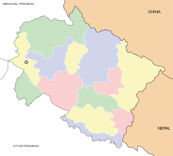
Dewalthal/देवलथल — village — Coordinates 29°42′00″N 80°13′00″E / 29.7°N 80.2167°ECoordinates: 29°42′00″N 80°13′00″E / 29.7°N 80.2167°E Country India State Uttarakhand District(s) Pithoragarh Population
• Density
10,000
• 323 /km2 (837 /sq mi)[1]
Time zone IST (UTC+05:30) Area 31 square kilometres (12 sq mi) Dewalthal (Hindi: देवलथल) is a sub-tehsil of Pithoragarh District in Uttarakhand state[2] in northern India. It has a population of 5,000[citation needed] and has a treasury, bank, post office, government, private school, rest house. This place is known as a military area, since every house has at least one person enlisted in the Indian army.[citation needed]
The name Dewalthal is derived from two words, Dew and sthal, which means Land of the Gods. In Kumaoni, name is pronounced as Daulthal (द्यौलथल) It is situated on Pithoragarh-Thal state Highway. Dewalthal is situated in a large valley, temples of many Folk & Hindu god & goddesses are situated here, like Lori Mallikarjun, Dektya Bhagwati, Nandanevi in Hardyo, Dharamghar, Malynath and others. It is the gateway to Eastern Himalayas. Panchchuli is visible from here. Soap stone mines are also found here.
References
- ^ http://gov.ua.nic.in/devbhoomi/village_wise.aspx?dcode=10&tcode=07&divcode=02&tname=%E0%A4%A6%E0%A5%87%E0%A4%B5%E0%A4%B2%E0%A4%A5%E0%A4%B2
- ^ District Pithoragarh : Profile
Categories:- Villages in Pithoragarh district
- Uttarakhand geography stubs
Wikimedia Foundation. 2010.


