- Mosley Common
-
Coordinates: 53°30′35″N 2°25′49″W / 53.5098°N 2.4304°W
Mosley Common 
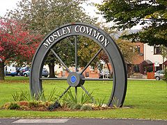
Mosley Common village sign
 Mosley Common shown within Greater Manchester
OS grid reference SD715015 Metropolitan borough Wigan Metropolitan county Greater Manchester Region North West Country England Sovereign state United Kingdom Post town MANCHESTER Postcode district M28, M29 Dialling code 01942/0161 Police Greater Manchester Fire Greater Manchester Ambulance North West EU Parliament North West England UK Parliament Leigh List of places: UK • England • Greater Manchester Mosley Common is a suburb of Tyldesley at the far-eastern edge of the Metropolitan Borough of Wigan, in Greater Manchester, England. It was anciently a hamlet in the east of the township of Tyldesley cum Shakerley, in the ancient parish of Leigh. The area of Mosley Common in 1747 was 34 acres (14 ha) statute s.[1]
Contents
History
The original name for the area was Hurst or Tyldesleyhurst (hyrst is Old English for "wooded hill")[2] It was called Mosseld Yard in 1301. Mosley the clearing on mossy ground. In 1695 the Common was part of the Tyldesley Manor. In 1698 Parr Bridge or Mosley Bridge was rebuilt in stone[3]
Industry
1n 1831 R. Worthington of Mosley Common built a weaving shed with 60 pairs of looms.[4] Parr Bridge Mill built in 1859 was a weaving shed, it had several owners and continued working into the 1950s.[5]
In 1838 City Pit and Gatley Pit owned by the Bridgewater Trustees[4]at New Manchester not far from the border with Worsley were working, New Manchester, not far from Ellenbrook is sometimes referred to as the "City". Deep mining arrived in the area when Mosley Common Colliery owned by the Bridgewater Trustees was sunk in the 1860s. In 1896 Mosley Common, "Nos. 1, 2 & 5" pits employed 748 men underground and 85 surface workers. Coal was mined from the Brassey, Crumbouke and Seven Foot mines. "Nos. 3 & 4" pits employed a further 406 underground workers and 57 above ground. Coal was got from the Trencherbone mine.[6] By 1919 it employed over 2,000 men. It was part of Manchester Collieries from 1929 to nationalisation in 1947 and was a national show pit during its 1950s. Mosley Common closed in 1968.[7][8]
Governance
Today Astley and Mosley Common form an electoral ward of the Metropolitan Borough of Wigan. The ward elects three councillors to the 75-member metropolitan borough council, Wigan's local authority. As of 2009, the three ward councillors for Astley and Mosley Common are one Conservative, one Labour and one Independent.[9]
Following a review of parliamentary representation in Greater Manchester, the Boundary Commission recommended that Mosley Common should be part of the Leigh constituency at the next general election.[10] At the 2010 General Election Andy Burnham retained the Leigh seat with 24,295 votes and a majority of 15,011, representing 51.3% of the vote. The Conservatives took 19.6% of the vote, the Liberal Democrats 17.0%, the UKIP 3.2%, the BNP 5.8%, the Christian Party 0.3% and Independents 2.8%.[11]
Geography
Further information: Geography of Greater ManchesterNeighbouring towns, villages, and places 
Tyldesley Little Hulton Walkden 
Tyldesley 
Ellenbrook  Mosley Common

Astley Boothstown Boothstown Education
In 1822 a Sunday School was built at Mosley Common, it was enlarged in 1881 and was used for religious services before the church was built.[12]
School Locality Description Website St. John's C.E. Primary Mosley Common Mosley Common Primary school website Religion
See also: List of churches in Greater ManchesterIn 1838 Primitive Methodists rented a cottage to use for worship, it was referred to as the "Ranter's Chapel". It was replaced by a chapel in 1868.[13]
In 1885 the Countess of Ellesmere laid the foundation stone for St John the Evangelist Church, it cost £4,250. It was a daughter church of Tyldesley St George. Church services were previously held in the school.[14]
References
Notes
- ^ Lunn (1995), p.48.
- ^ Mills (1998), p.404.
- ^ Lunn (1995), p.49.
- ^ a b Lunn (1995), p.80.
- ^ Lunn (1995), p.91.
- ^ North and East Lancashire's Mining Industry in 1896, projects.exeter.ac.uk, http://projects.exeter.ac.uk/mhn/1896-80.htm, retrieved 7 July 2009
- ^ Mining, tony.smith, the Boothstown website, http://freespace.virgin.net/tony.smith/mining.htm, retrieved 17 October 2009
- ^ Mosley Common Closed, cmhrc, http://www.cmhrc.co.uk/images/photogallery/last_shift.pdf, retrieved 1 November 2009
- ^ Wigan Metropolitan Borough Council, Councillor & Committee Details, wigan.gov.uk, http://rylands.wigan.gov.uk/councillordetails/template.aspx, retrieved 29 December 2009
- ^ Boundary Changes, statistics.gov.uk, http://www.statistics.gov.uk/pbc/review_areas/Greater_Manchester_Boroughs/downloads/PR_PN_Gtr_Man.doc, retrieved 29 December 2009
- ^ Election Results 2010, BBC, http://news.bbc.co.uk/nol/shared/election2010/results/constituency/c58.stm, retrieved 7 May 2010
- ^ Lunn (1995), p.65.
- ^ Lunn (1995), p.83.
- ^ Lunn (1995), p.103.
Bibliography
See also
- List of Collieries in Astley and Tyldesley
Categories:- Geography of Wigan
- Districts of Greater Manchester
Wikimedia Foundation. 2010.


