- Oregon Route 222
-
For the former OR 222, see Oregon Route 222 (1930s).
Oregon Route 222
Route information Maintained by ODOT Length: 11.16 mi (17.96 km) Existed: 2002 – present Major junctions South end:  OR 99 in Creswell
Near Rodgers Road near Creswell (End South Section)
 OR 58 near Pleasant Hill (Begin North Section)
North end:  OR 126 Business in Springfield
Highway system Oregon highways
Routes • Highways←  OR 221
OR 223  →
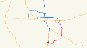
→Oregon Route 222 (OR 222) is an Oregon state highway, consisting of two disconnected sections.
The north section runs from OR 126 Business in Springfield to OR 58 near Pleasant Hill. Incorporating a temporary location for part of its route, the north section is 8.00 miles (12.87 km) long and runs northwest to southeast.
The south section runs from a point on Cloverdale Road north of Rodgers Road near Cloverdale, along Cloverdale Road, to OR 99 in Creswell. It is 3.16 miles (5.09 km) long and runs generally east–west.
OR 222 is known as the Springfield-Creswell Highway No. 222 (see Oregon highways and routes).
Both sections run entirely within Lane County. If connected, they would probably be considered to run north–south, as they would form the eastern half of a loop.
OR 222 was established in 2002 as part of Oregon's project to assign route numbers to highways that previously were not assigned, and, as of August 2008, was unsigned, although OR 222 route shields did appear on construction warning signs in 2008.
Contents
Route description
The north section of OR 222 begins at an intersection with OR 126 Business at Springfield and heads south via S 42nd st, then east, then south Via Jasper Rd. , through Jasper, Over the Middle Fork of the Willamette via Parkway Rd. then south Ending in Pleasant Hill, OR 222 intersects with OR 58, where the north section ends.
The Bypass of the S 49th approach to Jasper Rd. is the Bob Straub Pkwy beginning at the intersection of OR 126 and Business 126 (Main st.) South to Jasper Rd. Phase I of the Bob Straub Pkwy was a 0.5 mi (0.80 km) segment from Main St. to S 57th st. Opening in 2004 Phase II of the Pkwy was a 2 mi (3.2 km) segment from S 57th st. to Jasper Rd. Opening in 2008
The south section of OR 222 begins on Cloverdale Road approximately 1/10 mile north of Rodgers Road. It heads south and then west to Creswell, where it ends at an intersection with OR 99.
History
OR 222 was assigned to the Springfield-Creswell Highway in 2002.
Major intersections
Milepost City Intersection T0.00 Springfield OR 126 Business 8.00 Near Pleasant Hill OR 58 (End north section) 11.63 Cloverdale Begin south section 14.88 Creswell OR 99 Related routes
References
- Oregon Department of Transportation, Descriptions of US and Oregon Routes, http://www.oregon.gov/ODOT/HWY/TRAFFIC/TEOS_Publications/PDF/Descriptions_of_US_and_Oregon_Routes.pdf, page 28.
- Oregon Department of Transportation, Springfield-Creswell Highway No. 222, ftp://ftp.odot.state.or.us/tdb/trandata/maps/slchart_pdfs_1980_to_2002/Hwy222_1999.pdf
Categories:- State routes in Oregon
- Transportation in Lane County, Oregon


Wikimedia Foundation. 2010.