- Belcarra, British Columbia
Infobox Settlement
official_name = Village of Belcarra
other_name =
native_name =
nickname =
settlement_type = Village
motto =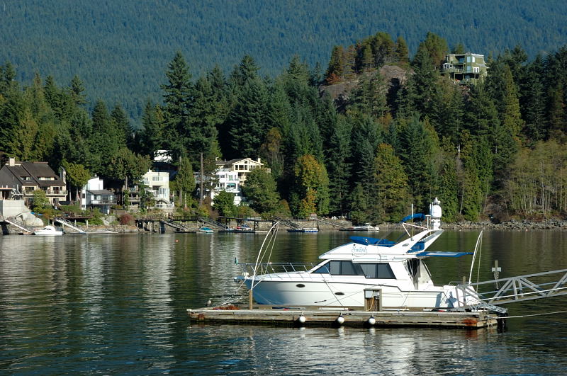
imagesize =
image_caption = Boat Launch at Belcarra
flag_size =
image_
seal_size =
image_shield =
shield_size =
city_logo =
citylogo_size =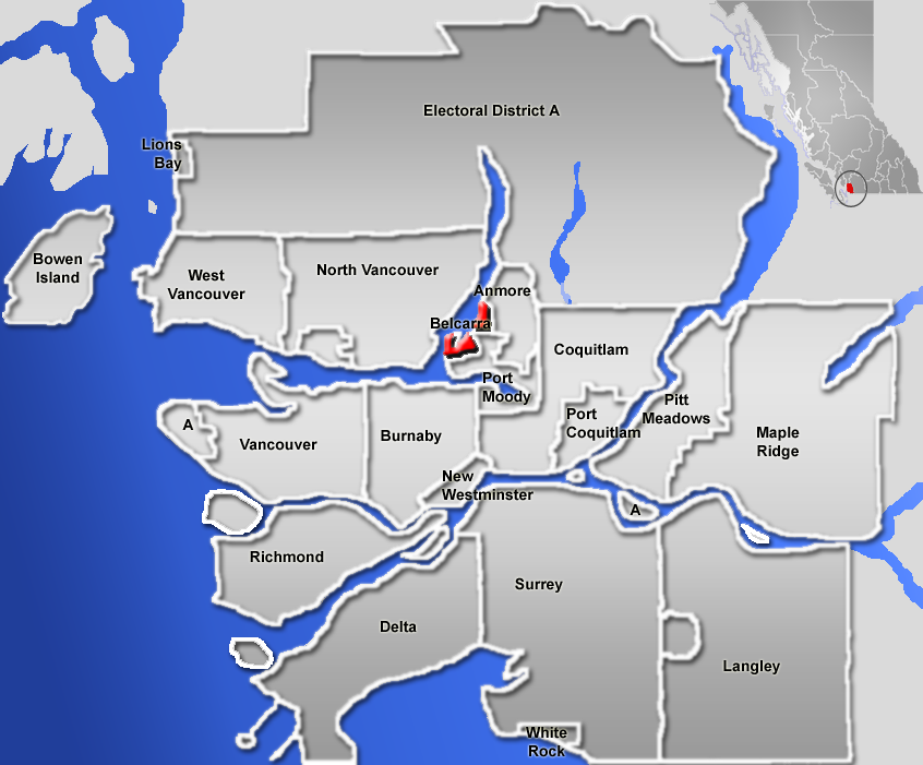
mapsize = 220px
map_caption = Location of Belcarra inBritish Columbia
mapsize1 =
map_caption1 =
image_dot_
dot_mapsize =
dot_map_caption =
dot_x = |dot_y =
pushpin_
pushpin_label_position =
pushpin_map_caption =
pushpin_mapsize =
subdivision_type = Country
subdivision_name = CAN
subdivision_type1 = Province
subdivision_name1 = BC
subdivision_type2 = Region
subdivision_name2 =Lower Mainland
subdivision_type3 = Regional district
subdivision_name3 = Greater Vancouver Regional District
subdivision_type4 =
subdivision_name4 =
government_footnotes =
government_type =
leader_title = Governing body
leader_name = Belcarra Village Council
leader_title1 = Mayor
leader_name1 = Ralph Drew
leader_title2 =
leader_name2 =
leader_title3 =
leader_name3 =
leader_title4 =
leader_name4 =
established_title =
established_date =
established_title2 = Incorporated
established_date2 = 1979
established_title3 =
established_date3 =
area_magnitude =
unit_pref =
area_footnotes =
area_total_km2 = 5.46
area_land_km2 =
area_water_km2 =
area_total_sq_mi =
area_land_sq_mi =
area_water_sq_mi =
area_water_percent =
area_urban_km2 =
area_urban_sq_mi =
area_metro_km2 =
area_metro_sq_mi =
area_blank1_title =
area_blank1_km2 =
area_blank1_sq_mi =
population_as_of = 2007
population_footnotes = [Government of British Columbia. [http://www.bcstats.gov.bc.ca/data/cen01/mun_rd.asp Municipal Statistics] ]
population_note =
population_total = 701
population_density_km2 =
population_density_sq_mi =
population_metro =
population_density_metro_km2 =
population_density_metro_sq_mi =
population_urban =
population_density_urban_km2 =
population_density_urban_sq_mi =
population_blank1_title =
population_blank1 =
population_density_blank1_km2 =
population_density_blank1_sq_mi =
timezone = PST
utc_offset = -8
timezone_DST =
utc_offset_DST =
latd= 49|latm= 19|lats= 7|latNS=N
longd= 122|longm= 55|longs= 36|longEW=W
elevation_footnotes =
elevation_m = 30
elevation_ft =
postal_code_type =
postal_code =
area_code =
blank_name =
blank_info =
blank1_name = Waterways
blank1_info =Indian Arm ofBurrard Inlet
website = [http://www.belcarra.ca Village of Belcarra]
footnotes = Belcarra, British Columbia, is a small community on the shore ofIndian Arm , a side inlet ofBurrard Inlet , and is part of theGreater Vancouver Regional District , nowMetro Vancouver . It lies northwest ofPort Moody and immediately east of theDeep Cove area of North Vancouver, across the waters of Indian Arm. Isolated by geography on a narrow peninsula, Belcarra is accessible by a single winding paved road or by water. Before incorporation it was commonly known as Belcarra Bay.It is largely a residential bedroom community for
Vancouver and its suburbs. Belcarra is the only community in this area that is not growing substantially. Even neighbouring Anmore, another tiny community has grown and changed, but Belcarra has remained a relatively small community. With a population of 682 as of 2001 [http://www.bcstats.gov.bc.ca/data/cen01/mun_rd.asp] , it has the lowest population of any independent settlement in the Vancouver area. Many residents in Belcarra have private docks and boats; even houses that are not on the water are sometimes able to procure a shared dock.Belcarra Regional Park winds its way through the village.History
Belcarra was a traditional camping area for the
Tsleil-waututh , theFirst Nations people whose territory it is in. Its beach and exposed westerly view give it a fine outlook and afternoon sun. The site was abandoned sometime between 1858 and 1864 when smallpox ravaged the Indian population. The remaining people moved their main permanent village across the inlet. The site at Belcarra was pre-empted early by European settlers, who were involved in an unfortunate murder in 1882. In turn, the land was deeded to the defending solicitor, who named the place Belcarra. A summer cabin was subsequently built. In time more cabins were built, and the local ferry company built a pier, park and campsite, for vactioners.Admiralty Point was government naval reserve, and was thus saved from development. The area is now a regional park.Belcarra adjoins several islands, and so it is a favourite spot for boaters. Bedwell Bay and Sasamat Lakealso are nearby, increasing the appeal.
Demographics
As of the
census of 2001, there were 682 people, 260 households, and 220 families residing in the village. Thepopulation density was 124.91/km² . There were 293 housing units at an average density of 53.66/km². The racial makeup of the village was 95.91%White , 2.91%Asian Canadian , 0.05%Iranian .The linguistic makeup of the village was English as the first language of 91.2% of the population, and 8.0% first learnt other languages. 94.2% of the population can speak only English, 5.1% can speak both English and French.
In the village the population was spread out with 17.6% under the age of 14, 11.0% from 15 to 24, 25.0% from 25 to 44, 40.4% from 45 to 64, and 6.6% who were 65 years of age or older. The median age was 44 years. For every 100 females there were 101.5 males.
For every 100 females age 15 and over, there were 107.3 males. There were 260 households out of which 26.9% had children living with them, 69.2% were married couples living together, 4.5% had a female householder with no husband present, and 19.2% of all households were made up of individuals. The average married-couple family size was 2.7.
Christians made up 55.1% of the population, or 22.8% Catholic, 27.2% Protestant, 0.0% Orthodox, and 5.1% other Christian. Other religions in the village include 1.5% Jewish, and 1.5% other religions. 41.2% of the population claimed to have no religious affiliation.
The median income for a household in the village was $100,995, and the median income for a family was $105,016. Males had an average income of $61,200 versus $34,840 for females. About 3.7% of the labour force was unemployed. The largest occupation categories were 23.5% employed in social science, education, government service and religion occupations, 17.3% business, finance and administration occupations, 17.3% sales and service occupations, and 16.0% in management occupations.
"Note: Percentages may not add up to 100 percent due to rounding of data samples."
References
Echoes Across the Inlet: Sparks,Border: 1989
External links
* [http://www.belcarra.ca Village of Belcarra] - official website
* [http://www.telemark.net/%7Erandallg/photos/20020609_lillooet/images/004.jpgAerial view of Belcarra (L) and Bedwell Bay (L), looking towards Indian Arm]urrounding Municipalities
Canadian City Geographic Location (8-way)
Northwest =North Vancouver
North = Anmore
Northeast = Anmore
West =North Vancouver
Centre = Belcarra
East = Anmore|
Southwest = Burnaby
South = Port Moody, Burnaby
Southeast = Port Moody, Coquitlam
Wikimedia Foundation. 2010.