- La Yeguada
-
La Yeguada 
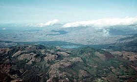
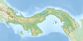
La Yeguada (foreground) in 1994. Laguna La Yeguada is also visible.Elevation 1,297 m (4,255 ft) Location Panama Range Serranía de Tabasará Coordinates 8°28′12″N 80°49′12″W / 8.47°N 80.82°WCoordinates: 8°28′12″N 80°49′12″W / 8.47°N 80.82°W Geology Type Stratovolcano Last eruption 1620 ± 100 years La Yeguada (also known as Chitra-Calobre) is a massive volcanic complex located in Veraguas Province, Panama, north of the Azuero Peninsula.
Exploration
The region was explored by several Panamanian adventurers and filibusters, which discovered that the mountain range was indeed not home for a volcano, but more for a caldera. The region is also home to several sorts of trees, mainly, Guayacanes which are now one of the most abundant trees in the region of Azuero, the valley is also an agricultural grassland since the Laguna La Yeguada' works as a natural irrigation system which prevents the region's animals and plants from dehydration.[citation needed]
The woods in the valley is where most of the Panamanian Cedro wood is produced.See also
References
- "La Yeguada". Global Volcanism Program, Smithsonian Institution. http://www.volcano.si.edu/world/volcano.cfm?vnum=140601-A.
Guatemala Acatenango · Agua · Almolonga · Atitlán · Fuego · Jumay · Moyuta · Pacaya · Santa María/Santiaguito · San Pedro · Santo Tomás · Siete Orejas · Tacaná · Tajumulco · Tecuamburro · TolimánEl Salvador Nicaragua Cosigüina · San Cristóbal · Telica · Cerro Negro · Momotombo · Apoyeque · Masaya · Mombacho · Concepción · MaderasCosta Rica Panama Note: volcanoes are ordered from north-west to south-east.Categories:- Mountains of Panama
- Volcanoes of Panama
- Stratovolcanoes
- Panama geography stubs
Wikimedia Foundation. 2010.


