- Concepción (volcano)
-
Concepción 
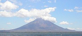
Elevation 1,610 m (5,282 ft) Prominence 1,579 m (5,180 ft) [1] Listing Ultra Location Rivas Department, Nicaragua Coordinates 11°32′16.8″N 85°37′19.2″W / 11.538°N 85.622°WCoordinates: 11°32′16.8″N 85°37′19.2″W / 11.538°N 85.622°W Geology Type Stratovolcano Last eruption 2011 Concepción is one of two volcanoes (along with Maderas) that form the island of Ometepe, which is situated in Lake Nicaragua in Nicaragua, Central America.
Concepción is an active stratovolcano that forms the northwest part of the Isla de Ometepe. Since 1883, Concepción has erupted at least 25 times; its last eruption was on 9 march 2010.[2] Concepción's eruptions are characterized by frequent, moderate-sized explosions. Active fumaroles are present just north of Concepción's summit crater.
See also
References
- ^ "Volcán Concepción, Nicaragua". Peakbagger.com. http://www.peakbagger.com/peak.aspx?pid=8148.
- ^ ABC News. "Volcano eruption covers villages in ash". http://www.abc.net.au/news/stories/2009/12/12/2769772.htm. Retrieved 2009-12-11.
- "Concepción". Global Volcanism Program, Smithsonian Institution. http://www.volcano.si.edu/world/volcano.cfm?vnum=1404-12=.
External links
Categories:- Mountains of Nicaragua
- Volcanoes of Nicaragua
- Stratovolcanoes
- Active volcanoes
- Nicaragua geography stubs
Wikimedia Foundation. 2010.

