- Crater Glacier
-
Crater Glacier 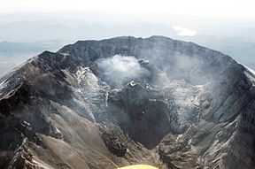
The Crater Glacier from the north in October 2006Type Mountain glacier Location Mount Saint Helens, Skamania County, Washington, USA Coordinates 46°11′48″N 122°11′15″W / 46.19667°N 122.1875°WCoordinates: 46°11′48″N 122°11′15″W / 46.19667°N 122.1875°W Thickness Ranges up to 656 ft (200 m) Terminus talus Status Expanding The Crater Glacier[1] (also known as Tulutson Glacier) is a geologically young glacier that is located on Mount Saint Helens, in the U.S. state of Washington. The glacier formed after the 1980 Eruption and due to its location, the body of ice grew rapidly, unknown to the public for nearly 20 years. The glacier once contained ice caves in the smooth ice before the post-2004 volcanic activity. The growth of the lava dome and volcanic eruptions since 2004 significantly altered the appearance of the glacier.[2] In the same time period, several agencies decided to put an official name on the glacier which, at first, was Tulutson Glacier. A later decision made Crater Glacier the official glacier name. Despite the volcanic activity, the glacier continued to advance and by mid-2008, the glacier completely encircled the lava domes.[2][3][4][5] In addition, new glaciers (rock or ice) have formed around Crater Glacier as well.[6]
Contents
History
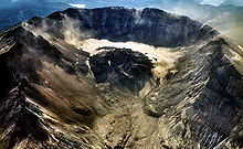
 The volcanically active and unstable crater floor months after the May 1980 Eruption, but before Crater Glacier was born via winter snowfall.
 The Crater Glacier from the north in October 2000, prior to the 2004-2008 eruptive cycle.
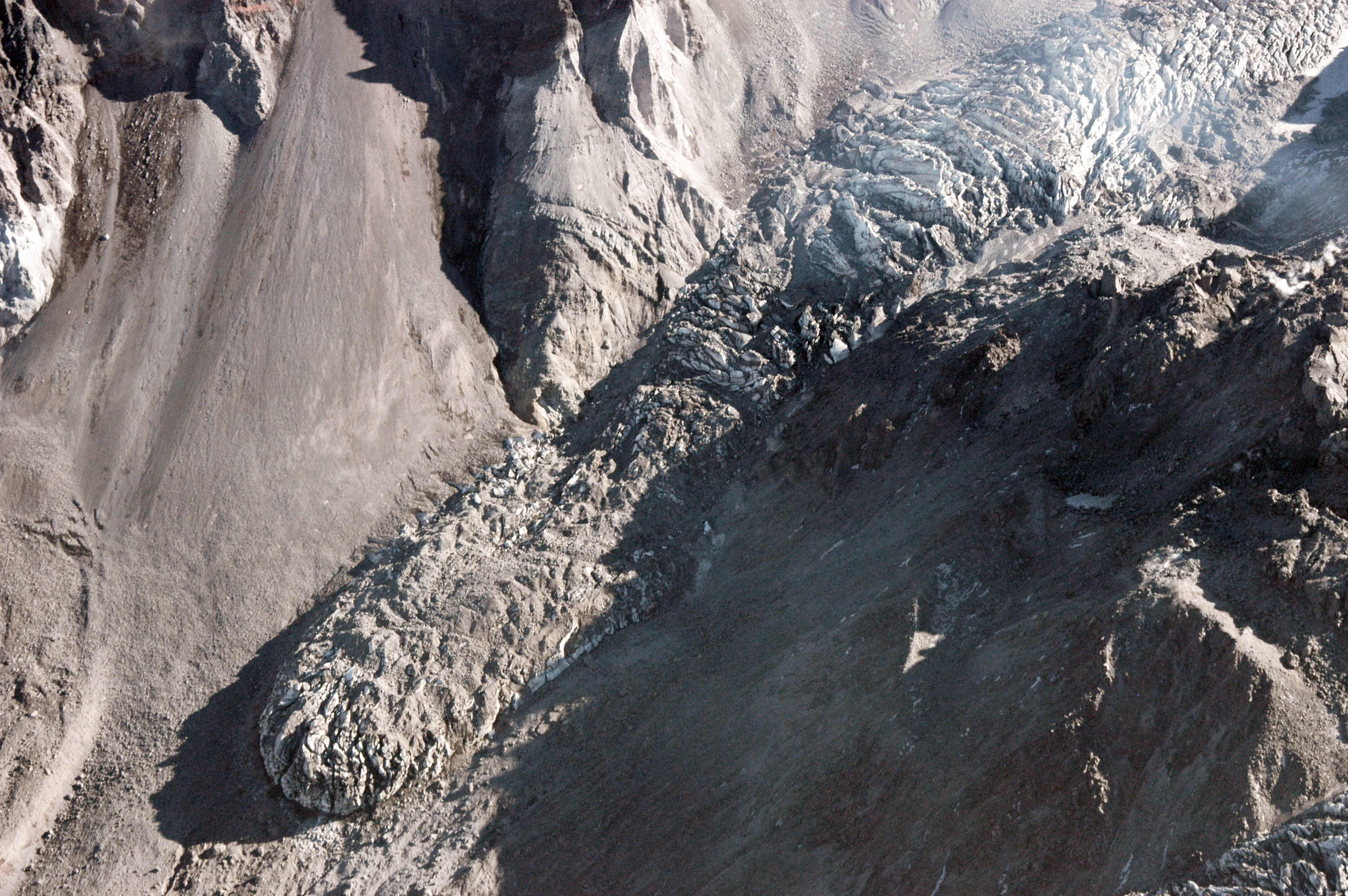
In the months after the eruption, the crater floor of Saint Helens remained hot and unstable, with five minor volcanic eruptions, and lava dome construction between May and October 1980.[7][8] After the eruptions ceased in the winter of 1980, the crater floor cooled down enough for snow and ice accumulation.[9] Beginning with snowfall in the winter of 1980-1981, the glacier began to grow very rapidly in the shadow of the crater.[10] The glacier thickened at a rate of as high as 50 ft (15 m) per year and advanced northward as much as 135 ft (41 m) a year.[11] This glacier growth was discovered by scientists working in the crater about seven to nine years later. However, the existence of the glacier was not publicized until 1999.[12] By 2004, Crater Glacier covered about 0.36 square mile (0.93 km²), about 20% of the glacier area in the pre-1980 glaciers,[2] and there was a western and eastern lobe flowing around the 1980s dome. Due to the gas emissions on the crater floor, there were glacier caves (ice caves) in the once smooth glacial ice, and several of them had been explored by the late 1990s.[13][14] With the volcanic activity starting in 2004, the glacier lobes were pushed aside and higher by the growth of new volcanic domes. The surface of the glacier, once mostly uncrevassed, turned into a chaotic jumble of icefalls heavily criss-crossed with crevasses and seracs due to movement of the crater floor and lava dome growth.[15] The new domes created since 2004 have almost split the Crater Glacier into two separate glaciers and melted 10% in volume of the glacier's ice.[2] Cold rock on the edge of the glacier insulated the glacier ice from the 1,300 °F (700 °C) lava spewing out of the lava dome, easing concerns of a catastrophic lahar caused by glacier melting.[16]
The thickness of the glacier continues to increase at a slower rate of 15 ft (5 m) per year.[3] Despite the 2004-2008 volcanic activity, the termini of the glacier continue to advance at 3 ft (1 m) per day.[3][16] By late-May 2008, the two arms of the glacier merged north of the lava dome.[2][5]
Description
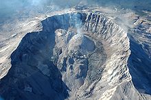
 Glaciers in the crater of Mount Saint Helens. The Crater Glacier is shaped in a horseshoe around the new domes that have developed in the crater. The west lobe of the glacier is visible in the bottom right and two more rock glaciers can be seen to the left of the east lobe.
True to its name, the glacier lies inside the north-facing crater left by the 1980 eruption of Mount St. Helens. A massive central lava dome emplaced from 1980 to 1987 occupies the center of the crater, and the glacier formed in the shape of a horseshoe around the dome, with two terminal moraines on the eastern and western sides. The elevation of the glacier is about 6,794 ft (2,071 m).[17] Heavy winter snowfall, repeated snow avalanches, rockfalls, and sun-shading by the surrounding cliffs to the south, led to the exceptionally rapid growth of this glacier.[18] Thus, the glacier composition is estimated to be six-tenths ice and four-tenths rock.[16] In addition, the glacier is very thick, averaging about 328 feet (100 m)[19] with a maximum thickness of around 656 feet (200 m); nearly as deep as Mount Rainier's Carbon Glacier.[2] None of the ice is older than the year 1980, however, the volume of the new glacier is about the same as all the pre–1980 glaciers combined.[11] The surface of the glacier looks dark and dirty in the summer due to the numerous rockfalls from the steep, unstable crater walls along with ash from eruptions, all of which helps to insulate and protect the growing glacier.[15][20][21][22][23] The 2004-2008 volcanic activity has created a new dome, which has split the glacier almost completely in half on the south end of the glacier.[15] In spite of the four-year lava dome building period, the glacier remains North America's youngest and fastest growing glacier.[11] With the joining of the termini on the north end of Crater Glacier in May 2008, the body of ice completely encircles the lava dome.[4][5] Meltwater from the glacier gives rise to Loowit Creek.[24]
- Pre-2004 eruption glacier caves of Crater Glacier
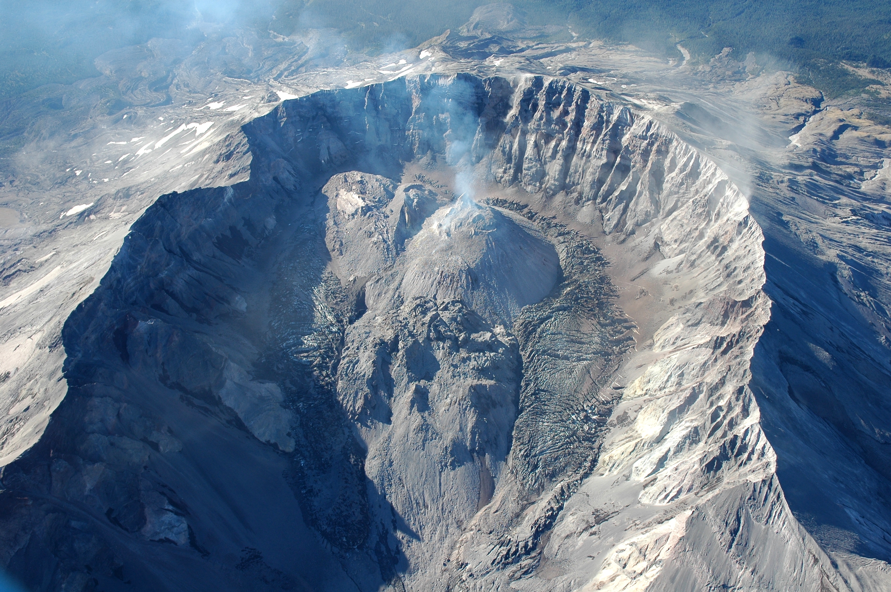
 New glaciers are forming on the crater wall, above and to the left of the lava dome (zoom in to view).
In 2000, glacier caves were discovered on the then-smooth glacier surface. Many of these glacier caves were big enough to explore, like the glacier caves on the summit of Mount Rainier. Most of the glacier caves were located near the 1980s lava dome, where hot steam and volcanic gas emissions from hidden fumaroles on the crater floor or lava dome melted holes in the young glacial ice.[10] About 7,900 feet or 2.4 km of underground caves and passageways in the glacier were mapped and studied.[12]
- Other glaciers and new rock glaciers
Since 2004, new glaciers have formed on the crater wall above Crater Glacier feeding rock and ice to Crater Glacier below. In addition, there are two rock glaciers to the north of the eastern lobe of Crater Glacier and one north of the western lobe.[6][25]
Naming the glacier
Since the glacier was first observed to be forming and actively flowing in the late 1980s, most scientists working on the mountain have referred to it informally as the "crater glacier". That name has been in wide use with the public (at least those who were aware of the glacier's existence) for the two decades since the glacier formed, and has appeared in several scientific publications too. A single scientific paper, the most complete published study of the glacier to date, referred to it as the "Amphitheater glacier,"[22] but that name has not been used otherwise.
Despite numerous observations and publications about the growing glacier in the late 1990s and early 2000s, no move was made to give the glacier a permanent and official name until late 2004, after the current eruptive cycle began and the new dome began to split the glacier.[13][14][21][26] At that time, a proponent from the Cowlitz tribe suggested the name "Tulutson Glacier," from the Cowlitz language word for ice. In March 2005, the Washington State Board on Geographic Names chose Tulutson over three other contenders (Crater, Spirit, and Tamanawas),[27] and so Tulutson Glacier became the de facto name.
However, the U.S. Board on Geographic Names had yet to make its decision, which would be official throughout the United States. The name Tulutson Glacier was submitted for consideration,[28] along with Crater Glacier[29] and Kraffts Glacier, which would have honored the volcanologists Katia and Maurice Krafft, killed by a pyroclastic flow in 1991. In June 2006, the U.S. BGN chose Crater Glacier because of its two-decade precedent of common use, despite objections from the state of Washington and the United States Forest Service which both preferred Tulutson.[30] The scientists at the USGS Cascades Volcano Observatory strongly supported Crater Glacier, and also commented that Tulutson may not be an appropriate name since the volcano “lies inland in a region where the native language was not Cowlitz but Sahaptin.”
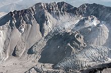
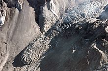 Icefall on east lobe of the Crater Glacier
After the decision, some controversy erupted following an editorial in a local newspaper protesting the decision, and the state of Washington "has indicated that the name Tulutson Glacier will continue to appear on State products, although if the feature melts soon, as is anticipated, this may not be a great concern."[31] Despite these protests, the glacier is now officially named the Crater Glacier, and it continues to expand even through the past two-and-half years of renewed volcanic activity. Since continued dome building has nearly split the glacier in two, shortly after their June 2006 decision the BGN received a follow-up proposal to name the two arms of the glacier, East Crater Glacier and West Crater Glacier,[31] but no further action has been taken on this matter.
References
- ^ The official name for this feature is "Crater Glacier", as decided by an 8-4 vote of the U.S. Board on Geographic Names, Domestic Names Committee, in June 2006. This supersedes the earlier decision by the Washington State Board on Geographic Names in March 2005 to name it "Tulutson Glacier", and is now the official name required for use in all US government documents and publications. See "USGS Geographic Names Information System: Crater Glacier". 2006-06-28. http://geonames.usgs.gov/pls/gnispublic/f?p=gnispq:3:::NO::P3_FID:2090268. Retrieved 2007-03-07.
- ^ a b c d e f "Volcano Review". US Forest Service. http://www.fs.fed.us/gpnf/mshnvm/volcano-review/documents/Volcano_Review_2008_Final_lowrez-201.pdf. Retrieved 2008-06-07.
- ^ a b c Barker, Brian (2008-05-15). "Against odds, glacier grows in cauldron of Mt. St. Helens". Katu.com. http://www.katu.com/news/outdoors/18948279.html. Retrieved 2008-06-07.[dead link]
- ^ a b Schilling, Steve (2008-05-30). "MSH08_aerial_new_dome_from_north_05-30-08". United States Geological Survey. http://vulcan.wr.usgs.gov/Imgs/Jpg/MSH/MSH08/MSH08_aerial_new_dome_from_north_05-30-08_med.jpg. Retrieved 2008-06-07. - Glacier is still connected south of the lava dome.
- ^ a b c Schilling, Steve (2008-05-30). "MSH08_aerial_st_helens_crater_from_north_05-30-08". United States Geological Survey. http://vulcan.wr.usgs.gov/Imgs/Jpg/MSH/MSH08/MSH08_crater_glacier_arms_touching_05-30-08_med.jpg. Retrieved 2008-06-07. - Glacier arms touch on North end of glacier.
- ^ a b "Laser Technology Helps Track Changes in Mount St. Helens". National Aeronautics and Space Administration, United States Geological Survey. 2004-10-25. http://www.nasa.gov/vision/earth/lookingatearth/mshelenslidar.html. Retrieved 2008-06-08.
- ^ Harris, Fire Mountains of the West (1988), page 212
- ^ Harris, Fire Mountains of the West (1988), page 213
- ^ Anderson Jr., Charlie. "Crater Ice 2002". http://glaciercaves.com/html/2002ic_1.HTM. Retrieved 2008-06-08.
- ^ a b PATTON, VINCE (2002-11-09). "Birth of a Glacier; Forms in Mouth of NW Volcano". kgw.com. http://glaciercaves.com/html/birtho_1.HTM. Retrieved 2008-06-08.
- ^ a b c "Mount St. Helens glacier (Crater Glacier) growing 50 feet per year". US Forest Service. 2004-09-20. http://www.iceagenow.com/Mount_St_Helens.htm. Retrieved 2008-06-08.
- ^ a b Anderson Jr., Charlie. "New Glacier Forming in the Crater". http://glaciercaves.com/html/anewgl_1.HTM. Retrieved 2007-09-26.
- ^ a b Anderson, Charles H., Jr.; Behrens, Christopher J.; Floyd, Gary A.; Vining, Mark R. (1998). "Crater firn caves of Mount St. Helens, Washington". Journal of Cave and Karst Studies 60 (1): 44–50.
- ^ a b Anderson, Charles H., Jr.; Mark R. Vining (1999). "Observations of Glacial, Geomorphic, Biologic, and Mineralogic Developments in the Crater of Mount St. Helens, Washington". Washington Geology 27 (2/3/4): 9–19.
- ^ a b c Schilling, Steve P.; David W. Ramsey, James A. Messerich, and Ren A. Thompson (2006-08-08). "USGS Scientific Investigations Map 2928: Rebuilding Mount St. Helens". http://pubs.usgs.gov/sim/2006/2928/. Retrieved 2007-03-07.
- ^ a b c Hill, Craig (2007-06-22). "Mount St. Helens’ Crater Glacier Advancing Three Feet Per Day". The News Tribune. Archived from the original on September 30, 2007. http://web.archive.org/web/20070930165508/http://www.thenewstribune.com/news/local/story/93350.html. Retrieved 2008-06-08. - Note: Full article is in the archives, or click here.
- ^ "Crater Glacier, Washington". TopoQuest. http://www.topoquest.com/place-detail.php?id=2090268. Retrieved 2008-07-10.
- ^ Topinka, Lyn (2001-05-23). "DESCRIPTION: Mount St. Helens Snowpack and Ice Accumulation". United States Geological Survey. http://vulcan.wr.usgs.gov/Volcanoes/MSH/SnowIce/description_msh_snow_ice.html. Retrieved 2008-06-08.
- ^ Topinka, Lyn (2006-03-01). "DESCRIPTION: Mount St. Helens Glaciers and Glaciations". United States Geological Survey. http://vulcan.wr.usgs.gov/Volcanoes/MSH/Glaciers/description_msh_glaciers.html. Retrieved 2008-06-08.
- ^ Brugman, Melinda M.; Austin Post (1981). "USGS Circular 850-D: Effects of Volcanism on the Glaciers of Mount St. Helens". http://pubs.er.usgs.gov/usgspubs/cir/cir850D. Retrieved 2007-03-07.[dead link]
- ^ a b Wiggins, Tracy B.; Hansen, Jon D.; Clark, Douglas H. (2002). "Growth and flow of a new glacier in Mt. St. Helens Crater". Abstracts with Programs - Geological Society of America 34 (5): 91.
- ^ a b Schilling, Steve P.; Paul E. Carrara, Ren A. Thompson, and Eugene Y. Iwatsubo (2004). "Posteruption glacier development within the crater of Mount St. Helens, Washington, USA". Quaternary Research (Elsevier Science (USA)) 61 (3): 325–329. Bibcode 2004QuRes..61..325S. doi:10.1016/j.yqres.2003.11.002.
- ^ McCandless, Melanie; Plummer, Mitchell; Clark, Douglas (2005). "Predictions of the growth and steady-state form of the Mount St. Helens Crater Glacier using a 2-D glacier model". Abstracts with Programs - Geological Society of America 37 (7): 354.
- ^ "LOOWIT FALLS". 2008-01-20. http://www.waterfallsnorthwest.com/nws/waterfall.php?st=WA&num=663. Retrieved 2008-12-15.
- ^ Haugerud, R. A.; Harding, D. J., Mark, L. E.; Zeigler, J., Queija, V., Johnson, S. Y. (2004-12). "Lidar measurement of topographic change during the 2004 eruption of Mount St. Helens, WA". Bibcode 2004AGUFM.V53D..01H.
- ^ Dininny, Shannon (2004-11-24). "Naming Mount St. Helens New Dome Confusing". LiveScience.com. http://www.livescience.com/forcesofnature/dome_name_041124.html. Retrieved 2007-03-07.
- ^ Associated Press (2005-03-08). "Mount St. Helens Glacier Gets A Name But May Be Short-Lived". KIRO-TV.com. Archived from the original on 2005-03-10. http://web.archive.org/web/20050310010310/http://www.kirotv.com/news/4263709/detail.html. Retrieved 2007-03-07.
- ^ "U.S. Board on Geographic Names Docket 389". 2005-06-01. Archived from the original on September 22, 2006. http://web.archive.org/web/20060922204747/http://geonames.usgs.gov/docs/dockets/docket389.pdf. Retrieved 2007-03-07.
- ^ "U.S. Board on Geographic Names Quarterly Review List 390". 2005-10-03. Archived from the original on September 22, 2006. http://web.archive.org/web/20060922204927/http://geonames.usgs.gov/docs/dockets/reviewlist390.pdf. Retrieved 2007-03-07.
- ^ "U.S. Board on Geographic Names Domestic Names Committee, 679th Meeting". 2006-06-05. Archived from the original on September 22, 2006. http://web.archive.org/web/20060922202200/http://geonames.usgs.gov/docs/minutes/DNCJun06Minutes.pdf. Retrieved 2007-02-28.
- ^ a b "U.S. Board on Geographic Names Domestic Names Committee, 680th Meeting". 2006-07-13. Archived from the original on November 16, 2006. http://web.archive.org/web/20061116162221/http://geonames.usgs.gov/docs/minutes/DNCJul06Minutes.pdf. Retrieved 2007-02-28.
See also
External links
Categories:- Glaciers of Mount St. Helens


Wikimedia Foundation. 2010.