- Cane Creek Mountains
Geobox|Range
name=Cane Creek Mountains
native_name=
other_name=Bass Mountains

image_caption=Bass Mountain (Left) and Cane Creek Mountain (Right), 2 of the highest peaks in the range.
country=United States
state_type=
region=Alamance County
region1=North Carolina
unit=
border=
border1=
geology=
period=
orogeny=Alleghenian orogeny
area=
length=21.17
length_orientation=SW
width=8.91
width_orientation=SE
highest=Cane Creek Mountain
highest_elevation=301
highest_lat_d=35
highest_lat_m=56
highest_lat_s=50.66
highest_lat_NS=N
highest_long_d=79
highest_long_m=26
highest_long_s=08.14
highest_long_EW=W
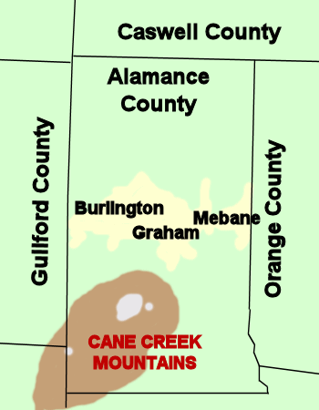
map_caption=Location of Cane Creek Mountains inAlamance County inNorth Carolina
map_size=175Cane Creek Mountains is a small mountain range that lies south of
Burlington, North Carolina . The range covers an area including Alamance County, Guilford County, Randolph County, and Chatham County inNorth Carolina .Formation
The mountains are typical of the rolling terrain of the piedmont region of North Carolina, and are somewhat similar in formation to the nearby
Caraway Mountains andUwharrie Mountains . The Cane Creek Mountains may have formed as a part of the larger coastal range that was once the Uwharries, which are thought to have formed as a part of the Alleghenian or Appalachian Orogeny 300-350 million years ago during the formation and rifting ofPangaea . This earlier range is through to have had peaks more than 20,000 feet high, which would rival theHimalayas , theAndes , or theAlaska Range . However,erosion has worn this old mountain range down. The highest peaks of this old range are now are found in theAppalachian Mountains on the eastern coast ofNorth America and in the Anti-Atlas Mountains ofMorocco inAfrica .The heavily-eroded hills of Piedmont, including the Cane Creek Mountains are remnants of the sizable mountain chain.
Geology
The Cane Creek Mountains lie in the
Carolina Slate Belt [http://pubs.usgs.gov/of/2006/1259/figures/Figure1.pdf USGS Map of Carolina Slate Belt] ] , a belt that consists of heated and deformedvolcanic andsedimentary rocks. The belt is best known for old abandonedgold mines. North Carolina led the nation in gold production for 50 years, between the discovery of a 17 pound (7.7 kg) gold nugget at theReed Gold Mine in Cabarrus County, NC nearCharlotte in 1799 and the discovery of gold during theCalifornia Gold Rush of 1849. Limited gold mining continues to take place, but severalmining companies continue to operate, both on the slate belt and in and near the Cane Creek Mountains. Most mineral production in the area is crushed stone for road aggregate andpyrophyllite for refactories, ceramics, filler, paint and insecticide carriers. [http://pubs.usgs.gov/info/ayuso1/ USGS Publication] ]Geography
The northern edge of the mountains begins on the southern bank of
Great Alamance Creek , approximately 4 miles south ofInterstate 40 in Graham and runs in a southwesterly direction towards Liberty in Randolph County. The range covers much of the southwest quadrant of Alamance County.While much of the range is a series of rolling hills that are common throughout the North Carolina Piedmont Region, there are several peaks in the Cane Creek Mountains located north of Snow Camp. The highest point in the range is Cane Creek Mountain, which is approximately 987 feet [http://www.topozone.com/states/NorthCarolina.asp?county=Alamance&feature=Summit TopoZone] ] , which is also the highest point in Alamance County.
Perhaps the most famous peak in the range is the 267m (902 ft)
Bass Mountain , home of an annualbluegrass music festival. Contrary to some local belief, Bass Mountain is not the highest peak in the range, although the range is occasionally referred to as the "Bass Mountains".History
The mountains and Alamance County were home to the local Native American tribes, including the Sissipihaw. The area saw major activity during the American Colonial and Revolutionary period, with several battles taking place in and near the range, including
Pyle's Massacre and theBattle of Alamance . There are several cave sites throughout the mountains where local historians theorize that small military parties may have been able to fortify their position. [http://www.alamance-nc.com/Alamance-NC/Departments/Recreation/Parks/Cedarock/Cedarock+Scenes/Hidden+Treasures+Video.htm Hidden Treasures of Cedarock Park] ]Current Use
The mountains are home to families, farms, and
television ,radio , and cellular communications towers. There is also afire tower located on top of Cane Creek Mountain that is no longer safe for use.Nearby Mountains
The piedmont region of North Carolina is home to several small mountain ranges and monadnocks, including:
*Stony Creek Mountain - a monadnock in Northern Alamance County that rises to 288 m (938 ft)
*Caraway Mountains - a small range in Randolph County, to the southwest
*Uwharrie Mountains - a range of mountains in four counties southwest of the Cane Creeks
*Occoneechee Mountain - a monadnock near theEno River in Orange County to the eastReferences
Wikimedia Foundation. 2010.