- Ōhata, Aomori
-
Ōhata
大畑町Former municipality Since March 1, 2005 Currently part of part of Mutsu 
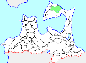
Ōhata's location in Aomori, Japan.Location Country Japan Region Tōhoku region Prefecture Aomori District Shimokita Physical characteristics Area 58.59 km² Population (as of February 1, 2006) Total 8,663 Density 147.8/km² Symbols Tree Chamaecyparis pisifera Flower Sakura Bird Common Gull Official website: Ohata official website Ōhata (大畑町 Ōhata-machi) was a town located in Shimokita District in northern Aomori Prefecture, Japan.
Ōhata Village was founded in 1889. It was elevated to town status on May 1, 1934. On March 14, 2005 it was merged into the neighboring city of Mutsu, along with the neighboring town of Kawauchi and village of Wakinosawa, and thus no longer exists as an independent municipality..
Located in northern Shimokita Peninsula facing Tsugaru Strait, the town of Ōhata had an economy based primarily on commercial fishing, primarily squid, octopus, salmon and sea urchin.
At the time of its merger, the town had an estimated population of 8,663 and a density of 147.8 persons per km². The total area was 58.59 km².
Ōhata was served by Route 279 (Japan) highway, but no railway service. Formerly (from 1939 to 2001), the Ōhata Line connected Ōhata Station with Shimokita Station via eight stations. The train has now been replaced by a bus service.

This Aomori Prefecture location article is a stub. You can help Wikipedia by expanding it. Categories:- Aomori geography stubs
- Dissolved municipalities of Aomori Prefecture
Wikimedia Foundation. 2010.
Look at other dictionaries:
Asahi Broadcasting Aomori — Co.,Ltd. (青森朝日放送株式会社, Aomori Asahi Hōsō Kabushiki gaisha?), also known as ABA, is a Japanese broadcast network affiliated with the ANN. It broadcasts to Aomori Prefecture from studio facilities located in Aomori City … Wikipedia
Mutsu, Aomori — Mutsu むつ市 City Mutsu city from Kamafuse yama … Wikipedia
Mutsu (Aomori) — Mutsu shi むつ市 Geographische Lage in Japan … Deutsch Wikipedia
Shimokita District, Aomori — Shimokita (下北郡; gun) is a district located in Aomori Prefecture, Japan. It occupies most of the northern handle of the Shimokita Peninsula with the exception of Mutsu city and contains the most northern point on the island of Honshū.As of 2003,… … Wikipedia
Shimokita-gun (Aomori) — Lage des Shimokita gun in der Präfektur Aomori Shimokita (jap. 下北郡, gun) ist ein Landkreis in der Präfektur Aomori in Japan. Er liegt am nördlichen Ende der japanischen Hauptinsel Honshū auf dem Gebiet der Shimoki … Deutsch Wikipedia
List of mergers in Aomori Prefecture — The following is a list of mergers that occurred in the 2000s in Aomori Prefecture, Japan.(as of March 1, 2006)Mergers from April 1, 1999 to March 31, 2000Mergers from April 1, 2000 to March 31, 2001Mergers from April 1, 2001 to March 31,… … Wikipedia
Liste der Mitglieder des Shūgiin (45. Wahlperiode) — Diese Liste gibt einen Überblick über alle Mitglieder des Shūgiin, des japanischen Abgeordnetenhauses, in der 45. Wahlperiode (2009–). Inhaltsverzeichnis 1 Fraktionen 2 Präsidium 3 Ausschüsse und Vorsitzende … Deutsch Wikipedia
Liste der Mitglieder des Shūgiin (44. Wahlperiode) — Die Liste gibt einen Überblick über alle Mitglieder des Shūgiin, dem japanischen Abgeordnetenhaus, in der 44. Wahlperiode (2005–2009). Inhaltsverzeichnis 1 Fraktionen 2 Präsidium 3 Ausschüsse und Vorsitzende 4 … Deutsch Wikipedia
Ominato-Tanabu — むつ市 Mutsu shi Geographische Lage in Japan … Deutsch Wikipedia
Ominatotanabu — むつ市 Mutsu shi Geographische Lage in Japan … Deutsch Wikipedia
 18+© Academic, 2000-2025
- Contact us: Technical Support, Advertising
Dictionaries export, created on PHP, Joomla, Drupal, WordPress, MODx.