Copicut River

Copicut River
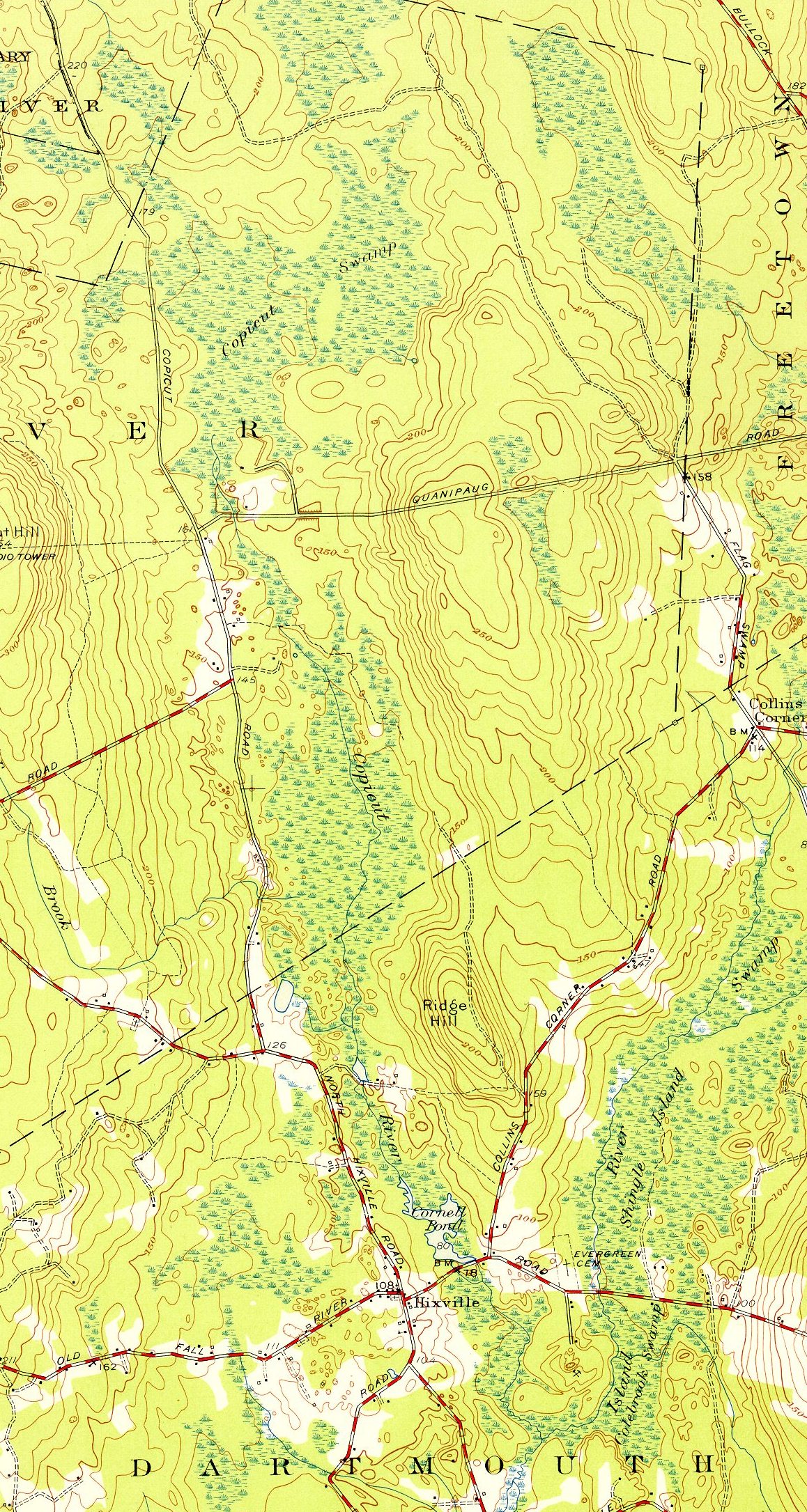
Copicut River and environs, circa 1951

The Copicut River, or Copecut River, is a 2.2-mile-long (3.5 km)[1] stream in the U.S. state of Massachusetts.

The river flows south from Copicut Reservoir (formerly the Copicut Swamp), in Dartmouth and Fall River, to Cornell Pond near Hixville in Dartmouth. From there the Shingle Island River drains into Noquochoke Lake, which the East Branch Westport River drains in turn into the Rhode Island Sound.

The river is currently polluted with Polychlorinated biphenyl (PCB) contamination from Re-Solve, Inc., which operated chemical reclamation facility nearby from 1956-1980. In 1983 the Environmental Protection Agency listed the area as a Superfund site, and in 1985 removed 15,000 cubic yards (11,000 m3) of contaminated soils and sludges. Since 1988 the Massachusetts Department of Public Health has advised against consuming fish from Cornell Pond or Copicut River.

References

  1. ^ U.S. Geological Survey. National Hydrography Dataset high-resolution flowline data. The National Map, accessed April 1, 2011


Wikimedia Foundation. 2010.

Игры ⚽ Поможем написать курсовую

Look at other dictionaries:

  • Copicut Woods — is a nature reserve and forest located in Fall River, Massachusetts. The property is owned by The Trustees of Reservations. External links Copicut Woods Trustees of Reservations website …   Wikipedia

  • Fall River, Massachusetts — Infobox Settlement official name = Fall River, Massachusetts imagesize = image caption = Downtown Fall River nickname = The Scholarship City motto = We ll Try image mapsize = 250px map caption = Location in Bristol County in Massachusetts… …   Wikipedia

  • Mystic River — For other uses, see Mystic River (disambiguation). Mystic River River …   Wikipedia

  • Neponset River — with Granite Avenue in background Basin countries United States Length 29 mi (47 …   Wikipedia

  • Charles River Reservation — Charles River Basin Historic District U.S. National Register of Historic Places U.S. Historic district …   Wikipedia

  • Nashua River Rail Trail — The Nashua River Rail Trail at the Groton School Pond in Groton, MA The Nashua River Rail Trail is a 12.5 mile (20.1 km) paved mixed use rail trail in northern Massachusetts and southern New Hampshire under control of the Massachusetts… …   Wikipedia

  • Mashpee River Reservation — is a park in Mashpee, Massachusetts on the Mashpee River. The Trustees of Reservations owns and maintains the park. Pristine shoreline, natural spawning areas, and excellent water quality make the Mashpee River one of Massachusetts finest sources …   Wikipedia

  • Connecticut River Greenway State Park — consists of a number of separate state land holdings in the Pioneer Valley of western Massachusetts. The park includes critical wildlife and plant habitat as well as areas providing public access to the Connecticut River. The Department of… …   Wikipedia

  • Charles River Peninsula — The Charles River Peninsula is a 30 acre (12 ha) nature preserve in Needham, Massachusetts owned and managed by the Trustees of Reservations. The Charles River turns nearly 180 degrees, creating the peninsula. A 20 acre (8 ha)… …   Wikipedia

  • Mystic River Reservation — The Mystic River Reservation is a publicly owned nature preserve located along the Mystic River in Massachusetts, United States. It forms part of the 75 square mile (190 km2) Mystic River Watershed, and runs through the towns of Arlington,… …   Wikipedia

Share the article and excerpts

Direct link
Do a right-click on the link above
and select “Copy Link”