- Chena River
-
Chena River 
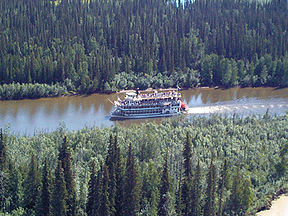
A paddle-wheel steamer on the Chena River near Fairbanks, AlaskaMouth Tanana River at Fairbanks 64°47′44″N 147°54′43″W / 64.79556°N 147.91194°W Basin countries United States Length 160 km (100 mi) Avg. discharge 1,500 ft³/s Basin area 1,995 mi² The Chena River is a 100-mile-long (160 km) river in the Interior region of the U.S. state of Alaska. It flows generally west from the White Mountains to the Tanana River near the city of Fairbanks, which is built on both sides of the river. The 2300 mile-long Yukon River flows from both the Tanana and Chena Rivers.
The river is fed by five tributaries: the North Fork, South Fork, West Fork, Middle (East) Fork and the Little Chena River. All empty into the Middle Fork, which is the main section of the river. The Chena River is surrounded by the Chena River State Recreation Area in the upper half of the river basin. The Chena River is used for recreational fishing and boating. During the winter months, it is also traveled by snowmachines and mushers (sled dogs).
The Chena River Lakes Flood Control Project dam, which includes a station for counting fish populations, is located about 45 miles up the Chena River from the mouth of the Tanana River. The river is home to several species of fish and is a spawning area for king salmon (Oncorhynchus tshawytscha). The dam was built in response to the 1967 Fairbanks flood which inundated much of the city. When closed, excess water is kept back upriver from Fairbanks and North Pole and, given enough water, spills into the Tanana River near North Pole about eight miles away from the Chena.[1]
The upper Chena is home to the Chena River State Recreation Area, noted for various forms of outdoor recreation.
Fish
The Chena river contains arctic grayling, arctic lamprey, burbot, chum salmon, humpback whitefish, king salmon, lake chubs, least cisco, longnose suckers, northern pike, round whitefish, slimy sculpins, and sheefish.[2]
Coordinates: 64°47′44″N 147°54′43″W / 64.79556°N 147.91194°W
References
- ^ http://www.gi.alaska.edu/ScienceForum/ASF16/1663.html
- ^ Alaska Department of Fish and Game. Rivers of the Lower Tanana Management Area, "The Chena River" Accessed August 6, 2009.
Categories:- Landforms of Fairbanks North Star Borough, Alaska
- Rivers of Alaska
- Interior Alaska geography stubs
Wikimedia Foundation. 2010.

