- New York State Route 11C
-
NYS Route 11C
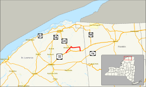
Map of northern New York with NY 11C highlighted in redRoute information Auxiliary route of US 11 Maintained by NYSDOT Length: 11.44 mi[2] (18.41 km) Existed: September 1, 1982[1] – present Major junctions West end:  US 11 in Stockholm
East end: US 11 in LawrenceLocation Counties: St. Lawrence Highway system Numbered highways in New York
Interstate • U.S. • N.Y. (former) • Reference • County←  NY 11B
NY 12  →
→New York State Route 11C (NY 11C) is a short state highway located in St. Lawrence County in the northern part of New York, United States. NY 11C is a northern alternate route of U.S. Route 11 between the towns of Stockholm and Lawrence that serves the hamlets of Winthrop and Brasher Falls. NY 11C briefly overlaps with NY 420 in Winthrop. Although NY 11C follows a mostly east–west routing, it is signed as a north–south route.
The current alignment of NY 11C was originally part of US 11. An alternate route of then-US 11 between Stockholm Center and Coteys Corner that bypassed the Brasher Falls area to the south was added to the state highway system on September 1, 1982, and designated as NY 11C. The alignments of US 11 and NY 11C between the two hamlets were flipped on June 13, 1992, placing both routes on their current routings.
Contents
Route description
NY 11C begins at an intersection with U.S. Route 11 in the hamlet of Stockholm Center within the town of Stockholm. The highway heads to the northeast, intersecting with a local road west of the Meadowbrook Golf Club. NY 11C continues on, crossing over the west branch of the St. Regis River and entering a residential area of Stockholm known as Winthrop. In the hamlet, NY 11C overlaps with NY 420 for one block. NY 420 turns off at the center of the community and heads toward Massena while NY 11C continues northeast out of Winthrop and into the town of Brasher.[3]
NY 11C heads into Brasher Falls and follows Ford and South Church Streets through the community. At the junction of Church and Main Streets, the route turns east to follow Main Street across the St. Regis River. Once on the opposite bank, NY 11C turns south onto a riverside roadway. The highway then veers to the southeast, and eventually to the east through largely forested areas as it passes into the town of Lawrence. NY 11C follows a routing parallel to that of the Brasher–Lawrence town line to North Lawrence, where it turns south onto Nicholville–Helena Road. The route continues to Cotey Corners, where it terminates at an intersection with US 11 and County Route 55.[3]
History
When the first set of posted routes in New York were assigned in 1924,[4] NY 2 was assigned to a highway extending from the Pennsylvania state line to the Canada – United States border. In northeastern St. Lawrence County, NY 2 served the hamlets of Stockholm Center, Winthrop, Brasher Falls, North Lawrence, and Cotey Corners.[5] NY 2 was renumbered to U.S. Route 11 in 1927.[6] On September 1, 1982, ownership and maintenance of County Route 110, a county road extending from Stockholm Center to Coteys Corner on a direct east–west routing, was transferred from St. Lawrence County to the state of New York as part of a highway maintenance swap between the two levels of government and the village of Canton.[1][7][8] The new state highway was initially designated as NY 11C.[9] On June 13, 1992, the alignments of US 11 and NY 11C between Stockholm Center and Coteys Corner were swapped, placing both routes on their modern alignments.[10][11]
Major intersections
The entire route is in St. Lawrence County.
Location Mile[2] Destinations Notes Stockholm 0.00 US 112.99  NY 420 south
Southern terminus of NY 11C / NY 420 overlap 3.14 NY 420 northHamlet of Winthrop; northern terminus of NY 11C / NY 420 overlap Town of Lawrence 11.44 US 11Hamlet of Coteys Corners 1.000 mi = 1.609 km; 1.000 km = 0.621 mi References
- ^ a b New York State Legislature. "Highway Law, Article 12, Section 341". http://public.leginfo.state.ny.us/menugetf.cgi?COMMONQUERY=LAWS. Retrieved May 30, 2009.
- ^ a b "2008 Traffic Volume Report for New York State" (PDF). New York State Department of Transportation. June 16, 2009. pp. 38–39. https://www.nysdot.gov/divisions/engineering/technical-services/hds-respository/NYSDOT%20TVR%202008%20by%20Route.pdf. Retrieved January 31, 2010.
- ^ a b Google, Inc. Google Maps – overview map of NY 11C (Map). Cartography by Google, Inc. http://maps.google.com/maps?sourceid=navclient&ie=UTF-8&rlz=1T4ADBF_enUS232US232&q=from:+RT-11C+%4044.760662,+-74.828613+to:+RT-11C+%4044.769948,+-74.819184+to:RT-11C+%4044.790076,+-74.792110+to:RT-11C+%4044.800557,+-74.758895+to:44.776121,-74.672884&um=1&sa=N&tab=wl. Retrieved March 24, 2008.
- ^ "New York's Main Highways Designated by Numbers". The New York Times: p. XX9. December 21, 1924.
- ^ Rand McNally and Company (1926). Rand McNally Auto Road Atlas (eastern New York) (Map). http://www.broermapsonline.org/members/NorthAmerica/UnitedStates/Midatlantic/NewYork/unitedstates1926ra_009.html. Retrieved May 30, 2009.
- ^ Automobile Blue Book. 1 (1927 ed.). Chicago: Automobile Blue Book, Inc. 1927. This edition shows U.S. Routes as they were first officially signed in 1927.
- ^ New York State Department of Transportation (1969). North Lawrence Digital Raster Quadrangle (Map). 1:24,000. http://www.nysgis.state.ny.us/gisdata/quads/drg24/dotpreview/index.cfm?code=b41. Retrieved May 30, 2009.
- ^ New York State Department of Transportation (1969). Brasher Falls Digital Raster Quadrangle (Map). 1:24,000. http://www.nysgis.state.ny.us/gisdata/quads/drg24/dotpreview/index.cfm?code=b40. Retrieved May 30, 2009.
- ^ Rand McNally and Company (1985). New York (Map). ISBN 0-528-91040-X.
- ^ American Association of State Highway and Transportation Officials (June 15, 1992). "Report of the Special Committee on U.S. Route Numbering to the Executive Committee". p. 6. http://cms.transportation.org/sites/route/docs/1992-USRN_Cmte.PDF. Retrieved May 30, 2009.
- ^ Rand McNally (1995). New York (Map). ISBN 0-528-96764-9.
External links
Categories:- State highways in New York
- Transportation in St. Lawrence County, New York


Wikimedia Foundation. 2010.