- New Zealand outlying islands
-
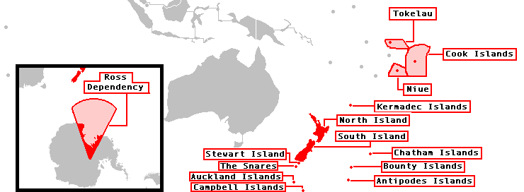
The New Zealand outlying islands comprise nine island groups, located in the subtropics and subantarctic, which are part of New Zealand but lie outside of the New Zealand continental shelf. Although considered as integral parts of New Zealand, seven of the nine island groups are not part of any region or district, but are instead designated as Area Outside Territorial Authority. The two exceptions are the Chatham Islands, which form a special territorial authority (island council) themselves, and the Solander Islands, which are part of the Southland Region and Southland District.
The term is also used sometimes to further encompass the Balleny Islands, a group of subantarctic islands technically considered part of Ross Dependency and covered by the Antarctic Treaty.
The five island groups of the New Zealand Sub-Antarctic Islands, including their territorial seas, are a World Heritage Site.
Contents
Island groups
 Topographical map of Antipodes Islands
The island groups from north to south:

Map showing the entire realm of New Zealand. Island Group (alternate name) Area
(km²)highest peak (m) location of
main islandnorth of North Island Kermadec Islands 33.08 Moumoukai peak (516) 29°16′S 177°55′W / 29.267°S 177.917°W Three Kings Islands (Ngamotukaraka, Manawa Tawhi) 4.86 (Great Island) (294) 34°09′S 172°08′E / 34.15°S 172.133°E east/south of South Island Chatham Islands (Wharekauri, Rekohu) 966.00 Maungatere Hill (294) 43°54′S 176°32′W / 43.9°S 176.533°W Solander Islands (Hautere) 0.70 (Solander Island) (330) 46°34′S 166°53′E / 46.567°S 166.883°E New Zealand sub-antarctic islands Bounty Islands 1.35 (Funnel Island) (88) 47°46′S 179°02′E / 47.767°S 179.033°E The Snares (Tini Heke) 3.41 (North East Island) (152) 48°01′S 166°32′E / 48.017°S 166.533°E Antipodes Islands 20.97 Mount Galloway (366) 49°41′S 178°48′E / 49.683°S 178.8°E Auckland Islands (Motu Maha) 625.60 Mount Dick (705) 50°42′S 166°05′E / 50.7°S 166.083°E Campbell Islands (Motu Ihupuku) 113.31 Mount Honey (569) 52°32′S 169°09′E / 52.533°S 169.15°E Outlying Islands 1800 Mount Dick (705) Population
The islands are all uninhabited except Chatham Islands. The remaining outlying islands are called Minor Islands.
There is a manned meteorological station on Raoul Island of the Kermadec Islands. The meteorological station on Campbell Island has been unmanned and automated since 1995. There was a meteorological station on the Auckland Islands from 1942 to 1945. The Three Kings Islands and the Auckland Islands were formerly inhabited. There have been failed settlement attempts on Raoul Island, the Antipodes Islands and the Auckland Islands. The Solander Islands have never been inhabited except by shipwrecked sailors or marooned stowaways (for the longest period, from 1808 to 1813 by five European stowaways).
See also
- British overseas territories
- List of Antarctic and sub-Antarctic islands
- List of islands of New Zealand
External links
Administrative divisions of New Zealand Commonwealth realm Realm of New Zealand States and dependencies New Zealand Ross Dependency Tokelau Cook Islands Niue Regions 11 non-unitary regions 5 unitary regions Chatham Islands Outlying islands outside any regional authority
(the Kermadec Islands, Three Kings Islands, and sub-Antarctic islands)Territorial authorities 13 cities and 53 districts Notes Some districts lie in more than one region These combine the regional and the territorial authority levels in one Special territorial authority The outlying Solander Islands form part of the Southland Region New Zealand's Antarctic territory Non-self-governing territory of New Zealand States in free association with New Zealand Categories:

Wikimedia Foundation. 2010.