- Crossover Island Light
-
Crossover Island Light 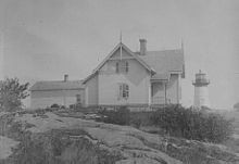
Crossover Island Light Location Crossover Island in the St. Lawrence River Year first constructed 1848 Year first lit 1882 Deactivated 1941 Foundation Stone Molehead Construction Cast iron
brick & wood liningTower shape Conical Markings / pattern White tower with Red Lantern Original lens Sixth Order Fresnel lens ARLHS number USA-206 Crossover Island Light Station

Nearest city: St. Lawrence, New York Coordinates: 44°29′49″N 75°46′42″W / 44.49694°N 75.77833°WCoordinates: 44°29′49″N 75°46′42″W / 44.49694°N 75.77833°W Area: 1.5 acres (0.61 ha) Governing body: Private MPS: U.S. U.S. Coast Guard Lighthouses and Light Stations on the Great Lakes TR NRHP Reference#: 07001037[3] Added to NRHP: October 3, 2007 Crossover Island Light is a lighthouse on the Saint Lawrence River in New York state near the Canadian border.
The lighthouse was established in 1848 and the last tower was first lit in 1882. The lighthouse was deactivated in 1941. The foundation is stone molehead and the lighthouse is made out of cast iron with brick and wood lining. The tower is a white conical tower with a red lantern. The original lens was a sixth order Fresnel lens.[4]
The lighthouse was added to the National Register of Historic Places as Crossover Island Light Station in 2007.
References
- ^ "Historic Light Station Information and Photography: New York". United States Coast Guard Historian's Office. 2009-08-08. http://www.uscg.mil/history/weblighthouses/LHNY.asp.
- ^ ARLHS World List of Lights
- ^ "National Register Information System". National Register of Historic Places. National Park Service. 2009-03-13. http://nrhp.focus.nps.gov/natreg/docs/All_Data.html.
- ^ Nancy L. Todd (June 2007). "National Register of Historic Places Registration: Crossover Island Light Station". New York State Office of Parks, Recreation and Historic Preservation. http://www.oprhp.state.ny.us/hpimaging/hp_view.asp?GroupView=102246. Retrieved 2009-06-14. See also: "Accompanying three photos". http://www.oprhp.state.ny.us/hpimaging/hp_view.asp?GroupView=102247.
- Hill, Ralph E. "Lighthouse Memories: Life on Crossover Island." The Keeper's Log (Summer 1991), pp. 18–22
Further reading
- Oleszewski, Wes. Great Lakes Lighthouses, American and Canadian: A Comprehensive Directory/Guide to Great Lakes Lighthouses, (Gwinn, Michigan: Avery Color Studios, Inc., 1998) ISBN 0-932212-98-0.
- Wright, Larry and Wright, Patricia. Great Lakes Lighthouses Encyclopedia Hardback (Erin: Boston Mills Press, 2006) ISBN 1550463993
Lighthouses of New York Ambrose Tower Light · Aunt Phebe Rock Light · Barber's Point Light · Barcelona (Portland Harbor) Light · Blackwell Island Light · Bluff Point Light · Braddock Point Light · Buffalo Light · Buffalo Harbor North and South entrance Lights · Buffalo Harbor South Entrance Light · Buffalo North breakwater East end Light · Buffalo North Breakwater South End Light · Cape Vincent Light · Carleton Island Light · Cedar Island Light · Cold Spring Harbor Light · Coney Island Light · Coxsackie Light · Crossover Island Light · Crown Point Light · Cumberland Head Light · Dunkirk Light · East Charity Shoal Light · Eatons Neck · Elm Tree Beacon Light · Esopus Meadows Light · Execution Rocks Light · Fair Haven Light · Fire Island Light · Fort Niagara Light · Fort Lafayette Light · Fort Tompkins Light · Fort Wadsworth Light · Galloo Island Light · Gardiners Point Island · Horse Island Light · Horton Point Light · Hudson-Athens Light · Huntington Harbor (Lloyd Harbor) Light · Kings Point Light · Latimer Reef Light · Little Gull Island Light · Little Red Lighthouse (Jeffrey's Hook) · Montauk Point Light · Moriches Light · New Dorp Light · North Brother Island Light · North Dumpling Light · Oak Orchard Light · Old Field Point Light · Old Orchard Shoal Light · Ogdensburg Harbor Light · Orient Long Beach Bar Light · Orient Point Light · Oswego Harbor West Pierhead Light · Plattsburgh Beacon Light · Plum Island Light · Point Aux Roches Light · Princes Bay Light · Race Rock Light · Rock Island Light · Romer Shoal Light · Rondout Light · Sands Point Light · Saugerties Light · Selkirk Light · Shinnecock Light · Sodus Outer Light · Sodus Point Light · South Brother Island Channel Range Light · South Buffalo North Side Light · Split Rock Point Light · Staten Island Light · Statue of Liberty · Stepping Stones Light · Stony Point (Henderson) Light · Stony Point Light · Strawberry Island Upper Cut Range Light · Stuyvesant Light · Sunken Meadows Light · Sunken Rock Light · Tarrytown (Sleepy Hollow) Light · Thirty Mile Point Light · (Three) Sisters Island Light · Throgs Neck Light · Tibbetts Point Light · Turkey Point (NY) Light · Watervliet Light · West Point Light · West Bank Light · Whitehall Narrows Light · Whitestone Point Light Categories:
- Lighthouses on the National Register of Historic Places in New York
- St. Lawrence County, New York Registered Historic Place stubs
- United States lighthouse stubs


Wikimedia Foundation. 2010.