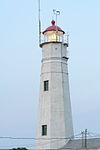
- Ogdensburg Harbor Light
-
Ogdensburg Light Location Lighthouse Poin, St.Lawrence River, Ogdensburg, New York Coordinates 44°41′52″N 75°30′12″W / 44.69778°N 75.50333°W Year first constructed 1834 Year first lit 1900 Deactivated Yes Construction Limestone Tower shape Square Markings / pattern White & Grey w/ Red Lantern Height 65 ft (20 m) ARLHS number USA-562 [1] Ogdensburg Harbor Light
Current Use: PRIVATELY OWNED
Owner/Manager: PRIVATE OWNER
Open to the Public? NO
Miscellaneous: ADDITION TO TOWER 1900
Contents
History
Ogdensburg Harbor Light is listed on the National Park Service's Maritime Heritage Program as Lighthouse to visit [2] and as one of New York's Historic Light Stations.[3]
Cultural
The Archives Center at the Smithsonian National Museum of American History has a collection (#1055) of souvenir postcards of lighthouses and has digitized 272 of these and made them available online. These include postcards of Ogdensburg Harbor Light [4] with links to customized nautical charts provided by National Oceanographic and Atmospheric Administration.
References
External links
- Lighthouse Friends site
- "Historic Light Station Information and Photography: New York". United States Coast Guard Historian's Office. http://www.uscg.mil/history/weblighthouses/LHNY.asp.
- National Park Service Historic Lighthouses
- NPS Ogdensburg Light
- Rudy & Alice
Berger, Todd R., Lighthouses of the Great Lakes, (Stillwater, MN: Voyageur Press, 2002), pp. 145–146
Further reading
Lighthouses of New York Ambrose Tower Light · Aunt Phebe Rock Light · Barber's Point Light · Barcelona (Portland Harbor) Light · Blackwell Island Light · Bluff Point Light · Braddock Point Light · Buffalo Light · Buffalo Harbor North and South entrance Lights · Buffalo Harbor South Entrance Light · Buffalo North breakwater East end Light · Buffalo North Breakwater South End Light · Cape Vincent Light · Carleton Island Light · Cedar Island Light · Cold Spring Harbor Light · Coney Island Light · Coxsackie Light · Crossover Island Light · Crown Point Light · Cumberland Head Light · Dunkirk Light · East Charity Shoal Light · Eatons Neck · Elm Tree Beacon Light · Esopus Meadows Light · Execution Rocks Light · Fair Haven Light · Fire Island Light · Fort Niagara Light · Fort Lafayette Light · Fort Tompkins Light · Fort Wadsworth Light · Galloo Island Light · Gardiners Point Island · Horse Island Light · Horton Point Light · Hudson-Athens Light · Huntington Harbor (Lloyd Harbor) Light · Kings Point Light · Latimer Reef Light · Little Gull Island Light · Little Red Lighthouse (Jeffrey's Hook) · Montauk Point Light · Moriches Light · New Dorp Light · North Brother Island Light · North Dumpling Light · Oak Orchard Light · Old Field Point Light · Old Orchard Shoal Light · Ogdensburg Harbor Light · Orient Long Beach Bar Light · Orient Point Light · Oswego Harbor West Pierhead Light · Plattsburgh Beacon Light · Plum Island Light · Point Aux Roches Light · Princes Bay Light · Race Rock Light · Rock Island Light · Romer Shoal Light · Rondout Light · Sands Point Light · Saugerties Light · Selkirk Light · Shinnecock Light · Sodus Outer Light · Sodus Point Light · South Brother Island Channel Range Light · South Buffalo North Side Light · Split Rock Point Light · Staten Island Light · Statue of Liberty · Stepping Stones Light · Stony Point (Henderson) Light · Stony Point Light · Strawberry Island Upper Cut Range Light · Stuyvesant Light · Sunken Meadows Light · Sunken Rock Light · Tarrytown (Sleepy Hollow) Light · Thirty Mile Point Light · (Three) Sisters Island Light · Throgs Neck Light · Tibbetts Point Light · Turkey Point (NY) Light · Watervliet Light · West Point Light · West Bank Light · Whitehall Narrows Light · Whitestone Point LightCategories:- Lighthouses in New York
- New York building and structure stubs
- United States lighthouse stubs
Wikimedia Foundation. 2010.

