- Murujuga
-
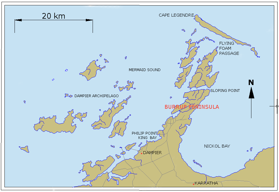
Murujuga (Yaburara/Ngarluma "hip bone sticking out"), is a peninsula (20°34′52″S 116°48′29″E / 20.581°S 116.808°E) often known as Burrup Peninsula in the Pilbara region of Western Australia, adjoining the Dampier Archipelago and near the town of Dampier. (The Dampier Archipelago is not to be confused with the Dampier Peninsula, 800 km to the north-east.)
The peninsula is a unique ecological and archaeological area since it contains the world's largest and most important collection of petroglyphs – ancient Aboriginal rock carvings some claim to date back as far as the last ice age about 10,000 years ago. The collection of standing stones here is the largest in Australia with rock art petroglyphs numbering over one million, many depicting images of the now extinct Thylacine ("Tasmanian Tiger").
 Map of Dampier Archipelago and Burrup Peninsula
The Dampier Rock Art Precinct, which covers the entire Archipelago, is currently the subject of much debate due to a large supply of off-shore natural gas in the area being sourced by Woodside Petroleum.
Contents
Development controversy
Concern around the ecological, historical, cultural and archaeological significance of the area has led to a campaign for its protection, causing conflict with industrial development on the site. The preservation of the Murujuga monument has been called for since 1969, and in 2002 the International Federation of Rock Art Organizations (IFRAO) commenced a campaign to preserve the remaining monument. Murujuga has been listed in the National Trust of Australia Endangered Places Register[1] and in the 2004, 2006, and 2008 World Monuments Watch by the World Monuments Fund.[2] No other sites in Australia have ever appeared in the World Monuments Watch.
Claims have been made that since 1963, 24.4 percent of the rock art on Murujuga has been destroyed to make way for industrial development.[3] However, the Western Australian government, responding to a question in parliament, has argued for a much lower figure, suggesting that approximately 4 percent of sites, representing approximately 7.2 percent of petroglyphs, have been destroyed since 1972.[4] However, as the Western Australian government has noted, there is no complete inventory of rock art in the region,[5] making assessments of current and future impacts on the site a challenging task.
In 1996, a Burrup Peninsula Land Use Plan and Management Strategy, prepared by the Burrup Peninsula Management Advisory Board, presented an approach to multiple land use on the Burrup Peninsula. The primary purpose of the Burrup Peninsula Land Use Plan and Management Strategy was to allocate land for industry, conservation, heritage and recreation following on from an earlier multiple land use plan for the Burrup Peninsula The Pilbara 21, Final Strategy Report (1992). The 1996 Plan attempted to balance competing land uses through the division of the Burrup Peninsula into two broad land use areas: (a) Conservation, Heritage and Recreation Area; and (b) an Industrial Area. The Plan recommend allocating approximately 5,400 hectares (62%) of the Peninsula for conservation, heritage and recreation, and associated uses – leaving (it is assumed) 38% of the area for “the allocation of industrial land (in addition to existing industrial leases) with an emphasis on port sites and strategic industry”. While comment is provided in the plan on “the value of the Northern Burrup for preservation of its renowned Aboriginal heritage and environmental values” no comment is made on the amount of rock art affected by development and recreational activities.[6]
Work commissioned by the West Australian National Trust led it to nominate the site for the National Trust Endangered Places list in 2002.[7] In 2004, funding was provided by American Express through the World Monuments Fund for further research and advocacy to be undertaken, with the goal of achieving national heritage status for the site. In 2006 the Australian Heritage Council advised the federal Environment and Heritage Minister that the site was suitable for National Heritage listing.[8]
The West Australian State government has continued to support development at the site, arguing a lack of cost-effective alternative sites and that geographical expansion of facility areas will be extremely limited. The campaign against development has blurred some traditional political boundaries, with former conservative party Resources Development Minister Mr Colin Barnett now supporting campaigns to save rock art in this area.[9]
The debate has placed the Australian national government in a difficult situation.[10] On the one hand, national heritage bodies have supported protection for the area, and the governments at national and state level have been of opposing political parties, giving the federal government reason to support site protection. On the other hand, the Western Australian economy has been crucial to Australia's economic wealth generally, and its export earnings in particular, and the national government will be reluctant to appear to interfere with that economic prosperity.
The protest campaign against development has garnered popular support:
42,000 personal messages were lodged with Woodside's Directors at their Annual General Meeting. Following shareholders questions at the AGM, Director Don Voelte finally admitted that the State Government had directed them towards developing amidst the rock art and that they had accepted.[11]
By June 2007, the debate continues, with the Australian government still to determine what if any intervention it may make in the case under federal heritage protection or other laws. The federal minister indicated support for National Heritage listing, however the question of site boundaries and management strategies was still under negotiation.[12]
The site was heritage listed in 2007.
On 7 July 2008, the Australian Government placed 90% of the remaining rock art areas of the Dampier Archipelago on the National Heritage List. Campaigners are now demanding that the Australian Government includue all of the undisturbed areas of the Dampier Arciapelago on the World Heritage List.
The area remains on the World Monument Fund's list of 100 Most Endangered Places in the World - the only such site in Australia - because of continued mismanagement of the heritage and conservation values of the Burrup.[13]
Notes
- ^ National Trust of Australia, Endangered Places Register 2004, http://www.heritageatrisk.org.au/WA_-_Dampiert_Rock_Art_Precinct.html
- ^ World Monuments Fund - Dampier Rock Art Complex
- ^ Robert G. Bednarik, Dampier Fact Sheet, October 2006, http://mc2.vicnet.net.au/home/dampier/web/facts.html
- ^ Hon. John Ford, answer to question on notice, Western Australia Legislative Council Hansard, 16 August 2005.
- ^ WA Department of Industry and Resources, Burrup Peninsula, Frequently Asked Questions, http://www.doir.wa.gov.au/investment/D78FA8400D554422991853F5A8B0263F.asp
- ^ See: Burrup Peninsula Land Use Plan and Management Strategy (1996) at http://www.dsd.wa.gov.au/documents/BI_BurrupLandUsePlan.pdf
- ^ National Trust of Australia (WA), Archaeology and rock art in the Dampier Archipelago, http://www.burrup.org.au/
- ^ ABC News Online, National Trust backs Burrup heritage report, 4 October 2006, http://www.abc.net.au/news/newsitems/200610/s1755743.htm
- ^ See public interview comments http://sixtyminutes.ninemsn.com.au/article.aspx?id=259414
- ^ See for example, AM, 3 October 2006, New factors prompt further Burrup Peninsula consideration, (transcript of radio report), ABC Radio, http://www.environment.gov.au/minister/env/2006/tr03oct206.html
- ^ GetUp campaign blog post, http://www.getup.org.au/blogs/view.php?id=138
- ^ The Hon. Malcolm Turnbull, Turnbull works for Burrup Solution, media release, 22 Feb 2007
- ^ Aboriginal rock art site vandalised, Australian Geographic, March 2, 2011.
External links
- ABC Online Greens push for Burrup rock art heritage listing
- ABC Online Pilbara Rock Art not Affected by Mining Emissions: Study
- Save Dampier Rock Art home-page
- National Trust information on Dampier Rock Art
- "Dampier Archipelago (including Burrup Peninsula), Karratha Dampier Rd, Dampier, WA, Australia (entry AHD105727)". Australian Heritage Database. Department of Sustainability, Environment, Water, Population and Communities. http://www.environment.gov.au/cgi-bin/ahdb/search.pl?mode=place_detail;place_id=105727.
- IFRAO
- Department of Industry and Resources (WA)
- Friends of Australian Rock Art campaign website
- The World Monuments Fund's Watch Listing for the Dampier Rock Art
Further reading
- Vinnicombe, P. (2002), Petroglyphs of the Dampier Archipelago: Background to Development and Descriptive Analysis, Rock Art Research, Volume 19, No 1, pp 3–27
See also
- Flying Foam massacre
- Visual arts of Australia
Categories:- Australian Aboriginal culture
- Australian Aboriginal art
- Rock art in Australia
- Heritage places of Western Australia
- Archaeological sites in Australia
- Pilbara
- Dampier Archipelago
- Australian National Heritage List
Wikimedia Foundation. 2010.