Dampier Peninsula

Dampier Peninsula
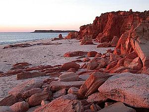
Cape Leveque at sunset

The Dampier Peninsula is a peninsula located north of Broome and Roebuck Bay in Western Australia. It is surrounded by the Indian Ocean to the west and north, and King Sound to the east. The northernmost part of the peninsula is Cape Leveque.

Contents

Aboriginal heritage

The peninsula is home to a rich heritage of aboriginal culture, with the communities of Bardi Community, Beagle Bay Community, Bobeiding Community, Djarindjin Community and Ngardalargin Community with numerous other smaller communities, pearling camps, tourist resorts and outstations.

Ecology

Many small trees, shrubs and animals live on and in the sea surrounding the peninsula, the most characteristic vegetation being pindan woodland.

Transport

The peninsula is traversed from south to north by the Cape Leveque Road.

By road: The Cape Leveque road from Broome to Beagle Bay is generally of poor condition and often closed during the wet season. Four wheel drive is recommended. It is bitumened from Beagle Bay to the northern towns. There are numerous tour operators running bus services on the peninsula.

By Air: There are air strips at Cape Leveque, Bardi, Djarindjin (Lombadina), Beagle Bay and some of the smaller communities and pearl farms.

Tourism

There are several tourist accommodation facilities such as Kooljamon (Cape Leveque) and Middle Lagoon (Middle Lagoon).

External links

Coordinates: 17°13′S 122°49′E / 17.21°S 122.81°E / -17.21; 122.81


Wikimedia Foundation. 2010.

Игры ⚽ Нужен реферат?

Look at other dictionaries:

  • Dampier Peninsula — Die Dampier Peninsula ist eine Halbinsel, die nördlich von Broome und der Roebuck Bay liegt, sie ist vom Indischen Ozean im Westen und Norden und vom King Sound im Osten umgeben. Den nördlichsten Teil der Halbinsel bildet das Cape Leveque.… …   Deutsch Wikipedia

  • Dampier Archipelago — …   Wikipedia

  • Dampier, Western Australia — Dampier Western Australia Map of Dampier, Western Australia and surrounding area …   Wikipedia

  • Dampier-Archipel — Der Dampier Archipel und die Burrup Halbinsel Gewässer Indischer Ozean …   Deutsch Wikipedia

  • Península de Doberai — (Semenanjung Doberai) Vista de satélite de la península Localización administrativa …   Wikipedia Español

  • Dampier to Bunbury Natural Gas Pipeline — Map of Western Australia showing the location of the Dampier to Bunbury Natural Gas Pipeline The Dampier to Bunbury Natural Gas Pipeline (DBNGP) is the longest natural gas pipeline in Australia. It is 660mm in diameter, which also makes it one of …   Wikipedia

  • Dampier — /dam pee euhr, damp yeuhr/, n. William, 1652 1715, English navigator, explorer, buccaneer, and writer. * * * ▪ Western Australia, Australia       town and port in Roebourne shire, northwestern Western Australia, on Nickol Bay (an inlet of the… …   Universalium

  • Dampier Strait (Indonesia) — This article is about the strait in Indonesia. For the same strait name in Papua New Guinea, see Dampier Strait (Papua New Guinea). Dampier Strait in Indonesian province of West Papua is a strait that separates Bird s Head Peninsula and the Raja… …   Wikipedia

  • Dampier Land — /ˈdæmpiə lænd/ (say dampeeuh land) noun the historical name for the land forming a large peninsula between Roebuck Bay and King Sound in north western WA. {named after William Dampier1} …  

  • Archipiélago Dampier — Saltar a navegación, búsqueda Archipiélago Dampier (Dampier Archipelago) Localización administrativa País   …   Wikipedia Español

Share the article and excerpts

Direct link
Do a right-click on the link above
and select “Copy Link”