- Marlow By-pass Bridge
-
Marlow By-pass Bridge 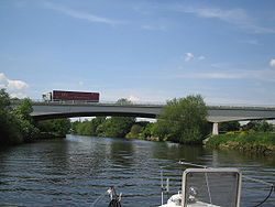
Marlow By-pass BridgeCarries A404 road Crosses River Thames Locale Marlow Design Balanced cantilever Material Concrete Total length 560 feet (170 m)[1] Width 75 feet (23 m)[1] Height 19 feet 9 inches (6.02 m)[2] Longest span 85 feet (26 m)[1] Number of spans 3 Opened 1972 Marlow By-pass Bridge is a road bridge across the River Thames in England. It carries the A404 road between Maidenhead, Berkshire and High Wycombe, Buckinghamshire. and crosses the Thames on the reach between Cookham Lock and Marlow Lock.
The bridge forms part of the Marlow by-pass to the east of the town. It was built in 1972.
The area underneath the bridge is used for boat storage by the adjacent Scout Water Centre at Longridge.
See also
- Crossings of the River Thames
References
Coordinates: 51°33′58″N 0°45′43″W / 51.56611°N 0.76194°W
Next crossing upstream River Thames Next crossing downstream Marlow Bridge (road) Marlow By-pass Bridge Bourne End Railway Bridge
(railway and pedestrian)Categories:- Bridges across the River Thames
- Bridges in Berkshire
- Bridges in Buckinghamshire
- Bridges completed in 1972
- Thames Path
- Buckinghamshire building and structure stubs
- Berkshire building and structure stubs
- United Kingdom bridge (structure) stubs

Wikimedia Foundation. 2010.