- Charwelton railway station
-
Charwelton 
Charwelton in 1909 during a visit by the Royal Train Location Place Charwelton Area Daventry Grid reference SP536560 Operations Original company Great Central Railway Pre-grouping Great Central Railway Post-grouping London and North Eastern Railway
London Midland Region of British RailwaysPlatforms 2 History 15 March 1899 Opened 4 March 1963 Closed Disused railway stations in the United Kingdom Closed railway stations in Britain
A B C D–F G H–J K–L M–O P–R S T–V W–ZCharwelton railway station is a closed station on the former Great Central Railway main line,[1] the last main line to be built from the North of England to London. The station opened with the line on 15 March 1899 serving the village of Charwelton in Northamptonshire.
Contents
History
The station was one of the standard island platform design typical of the London Extension, and here it was the more common "cutting" type reached from a roadway (the Banbury to Daventry road, today's A361, formerly the B4036), that crossed over the line.[2] Just to the south were Charwelton Watertroughs, while to the north was Catesby Tunnel, 2,997 yards in length, about 1.7 miles (2.74 km).
In 1917 the Park Gate Iron and Steel Company, based at Parkgate near Rotherham, South Yorkshire, opened an ironstone quarry at the nearby village of Hellidon, and constructed a standard gauge industrial railway just over a mile in length to transport the stone to the main line. Production ceased in June 1933 but the Ministry of Supply ordered its resumpton in May 1941. It ceased once more in October 1945, but was resumed yet again in May 1951.[citation needed] The goods yard at Charwelton was a hive of activity at its peak, with up to 200 wagons stabled in its sidings at any one time.[2] As late as 1961 a new quarry was opened at Hellidon, but this proved less successful and so both quarry and line closed on 18 November that same year, the branch being dismantled in June 1963 and the sidings at Charwelton following in 1964.[3][4]
Charwelton station closed to passengers and goods on 4 March 1963, the line itself on 5 September 1966.[2] The station buildings had already gone before the line closed, though the platform remained until the mid-1980s as so - more critically - did the road bridge. This became something of a traffic hazard owing to its steep approaches, a sharp kink in the road at the apex on the west side, and poor visibility. In 1985 the bridge was demolished and the road straightened and lowered. The platform was removed at the same time. The road now cuts across the site of the platform roughly level with the "Charwelton" name-sign in the 1909 photograph above right.
Route
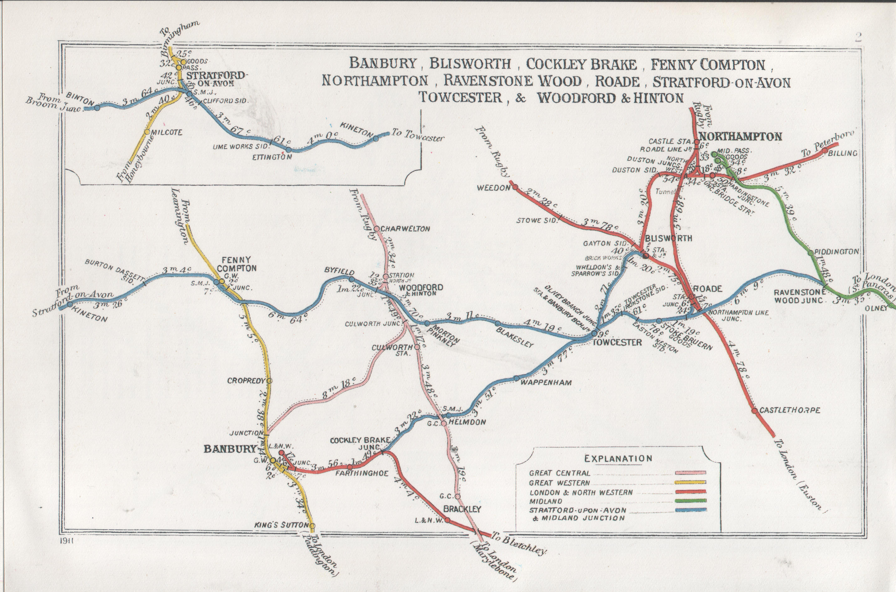
 A 1911 Railway Clearing House map of railways in the vicinity of Charwelton
Preceding station Disused railways Following station Woodford Halse British Railways
Great Central Main LineBraunston and Willoughby See also
Notes
- ^ Conolly 1976, p. 10, section B4
- ^ a b c Catford 2008
- ^ Tonks 1988, pp. 124–136
- ^ Christensen 1993, Charwelton Ironstone
References
- Catford, Nick (14 December 2008). "SB-Sites:Charwelton Station". Subterranea Britannica. http://www.subbrit.org.uk/sb-sites/stations/c/charwelton/index.shtml. Retrieved 8 November 2009.
- Christensen, Mike (Summer 1993). Karau, Paul; Beale, Gerry. eds. "Charwelton Ironstone". British Railway Journal (Didcot: Wild Swan) 5 (47): 334–342. http://www.steamindex.com/brj/brj5.htm. Retrieved 8 November 2009.
- Ian Allan (1976). British Railways Pre-Grouping Atlas and Gazetteer (Map). 1" = 8 miles, Cartography by W. Philip Conolly (5th ed.). ISBN 0 7110 0320 3.
- Tonks, Eric S. (October 1968). "Ironstone Tramways of the Midlands (7) Byfield & Charwelton". The Industrial Railway Record (The Industrial Railway Society) 2 (21): 317–319/324–328. http://www.irsociety.co.uk/Archives/21/Ironstone_7.htm. Retrieved 8 November 2009.
- Tonks, Eric (April 1988). "Northern Group: The Northamptonshire Quarries: Charwelton Quarries". Part II The Oxfordshire Field. The Ironstone Quarries of the Midlands. Cheltenham: Runpast. ISBN 1 870754 02 6.
External links
Coordinates: 52°11′59″N 1°13′02″W / 52.19963°N 1.21718°W
Closed railway stations in Northamptonshire Northampton to Market Harborough line Banbury to Blisworth Stratford-upon-Avon and Midland Junction Railway Northampton and Peterborough Railway Northampton Bridge Street · Billing · Castle Ashby & Earls Barton · Wellingborough London Road · Ditchford · Irthlingborough · Ringstead & Addington · Thrapston Bridge Street · Thorpe · Barnwell · OundleRugby to Peterborough East Market Harborough to Bedford Higham Ferrers branch Great Central Main Line Northampton Loop Line Rugby to Bletchley Welton · Weedon · Blisworth · RoadeKettering to Huntingdon Cranford · Twywell · Thrapston Midland Road · RaundsKettering to Melton Mowbray Rugby and Stamford Railway Lilbourne · Yelvertoft & Stanford ParkWeedon to Marton Junction Other stations Ashley & Weston · Aynho Park · Aynho for Deddington · Brackley Town · Northampton St. John's Street · PiddingtonCategories:- Disused railway stations in Northamptonshire
- Former Great Central Railway stations
- Railway stations opened in 1899
- Railway stations closed in 1963
- East Midlands railway station stubs

Wikimedia Foundation. 2010.