- Bear Camp Road
-
 Map of Bear Camp Rd and surrounding wilderness.
Bear Camp Road is a rugged mountain road traversing the Klamath Mountains in Josephine and Curry counties in the U.S. state of Oregon. Bear Camp Road is a combination of Bureau of Land Management (BLM) Road 34-8-36 (also known as Galice Road) starting just south of Galice and United States Forest Service (FS) Road 23, which continues from the 12-mile (19 km) point on 34-8-36 to Agness. The road is named for a camp and viewpoint at the 4,600-foot (1,400 m) summit near the Josephine/Curry county line.
The road is a common route to recreational opportunities, including hunting and rafting, and is also the only route to the Oregon Coast between the California-Oregon border and the Rogue River. It is a paved, one-lane road with infrequent turnouts and a few gravel sections. At both ends, the road quickly climbs up to the crest of the Coast Range, and the majority of the road is at high elevation on top of a long ridge.
Bear Camp Road is a rugged, narrow, crooked road, which is not suitable for travel in the winter. Numerous motorists have been stranded for days or weeks on Bear Camp Road or one of the many gravel roads that branch off from it. Dewitt Finley and James Kim both died after being stranded on the road in winter.
Contents
Kim family ordeal
Main article: James KimBear Camp Road came into the national spotlight in late 2006 when James Kim, his wife Kati, and their two daughters attempted to reach Gold Beach via this route. They missed an Interstate 5 exit to their intended route, Oregon Route 42, and decided to take Bear Camp Road instead. Late on the night of November 25, 2006, they missed signs warning of possible snow and continued up the mountain road. At the intersection of the BLM and FS sections of the road, they accidentally turned off of Bear Camp Road and eventually ended up lost 16 miles (26 km) down an unpaved side road before stopping for the night. A snowstorm trapped them at this location.
The family waited for rescue, surviving on limited resources. After spending six days waiting for rescue, James Kim left the car to seek help. He and his wife had attempted to locate their position using area road maps, and had estimated that the small town of Galice, Oregon was only four miles away. They were actually 33 miles (53 km) from the town by road. [1]
He left the car at 7:30 a.m. on Saturday, December 2 and backtracked down the road on which they were stranded. Approximately 11 miles (18 km) down the road, he turned down into the Big Windy Creek canyon. James Kim hiked through treacherous and dangerous terrain to reach the creek, and apparently was attempting to follow it to the Rogue River in an attempt to find help. [2]
On the following Monday, searchers found Kati Kim and her children near the car, but could not locate James Kim. Searchers traced James Kim's path down Big Windy Creek’s canyon in an effort to find him. His body was recovered in Big Windy Creek on Wednesday, December 6. According to medical examiners, James Kim died of hypothermia, but a precise time of death was not known.[1] He had walked approximately 16 miles (26 km) trying to find help. [3]
Initial reports from government officials contained incorrect information about the position of the Kims' car and its proximity to the location where James Kim's body was found. It was first thought that the Kims' car was stranded at the intersection to the access road for Black Bar Lodge (42°39′1.25″N 123°44′54.15″W / 42.6503472°N 123.748375°W). They were actually six miles from this shelter. Mapping errors caused this miscalculation, according to officials.[3] The actual location was: 42°41′26″N 123°46′36″W / 42.690430°N 123.776577°W
Following the conclusion of the search and recovery efforts, government officials confirmed that a gate blocking access to the road on which the Kims were stranded should have been locked, but was not. Bureau of Land Management employees dispatched to close the gate had decided against locking the gate due to the possibility of hunters being stranded inside.[4] [5] [6]
Since the incident, the Forest Service and Bureau of Land Management has installed additional numerous large signs on the approaches to Bear Camp Road, warning that the road may be impassible during winter months. Also, the directional sign ("To Gold Beach and Coast") at the spot where the Kims turned onto the wrong road, has been moved and replaced. At the spot, the paved through road is narrow and steeply uphill while the gravel side road is much wider and more level. The location and arrow direction on the old sign was confusing and ambiguous, especially in snow when it would be impossible to see that the narrow uphill road is paved while the wide level road is not.
Previous incidents
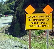 Warning sign near the west end outside Gold Beach, Oregon
DeWitt Finley
In 1994, a man traveling over Bear Camp Road died after being stranded for nine weeks. The victim, Dewitt Finley, was a camper salesman from Montana. He was attempting to drive from Gold Beach to Grants Pass and became snowbound. He kept a journal while stranded on the road, and ultimately died of starvation.[7] His body wasn't recovered until May 1995, when it was discovered by a group of local teenagers.[8] There is no indication that Finley ever attempted to hike out, or ever left his camper. Some accounts indicate that Finley would have likely survived if he had attempted to hike out.
In his journal, Finley wrote, "I have no control over my life its all in His Hands. 'His will be done.' Death here in another month or so, or He sends someone to save me", leading some to speculate that he looked to divine intervention and his strong religious devotion to save him, or that other psychological/emotional factors led him to "give up."[9]
The Stivers
In March 2006 six members of an Ashland, Oregon family were stranded in their snowbound motor home for two weeks. In addition to the two Stivers, the group included Stivers's parents, the Higginbothams; and the Stivers' two children. The RV was stranded on the spur road to Calvert Airstrip near its intersection with the BLM Glendale-to-Powers Bike Route after that road passes Marial Junction, about 15 miles (24 km) west of Glendale. Unlike the route of James Kim and his family who turned west up BLM 34-8-36 toward Bear Camp Road and Gold Beach, the Stivers-Higginbotham group took a different road, having missed the turnoff that the Kims took toward Bear Camp at the start of BLM 34-8-36. Stivers-Higginbotham's route went north through Galice and on to Grave Creek, there crossing the bridge over the Rogue River, and next, heading north up Mount Reuben Road. When they got to the Glendale-to-Powers bike route, they turned west where they later became stuck in snow on the BLM airstrip spur, while trying to head back down it after turning around at the airstrip. Their RV had become stuck north of the Rogue River in March, about seven miles (11 km) NNE, geographically, from where the Kims car was stranded in late November 2006.
Confusion about the whereabouts and intentions of the group caused law enforcement officials to call off their search after five days. Police had received conflicting information on the group's destination, and some officials considered treating the case as a kidnapping.
Inside the motor home, the family was able to see television news reports of the search effort, but became convinced that rescuers would not find them. Two of the six in the group hiked out to search for the searchers, and were found (by accident) by Bureau of Land Management employees on routine patrol. The other members of the group were rescued later that day. All were in good condition.[10]
Family members Elbert and Becky Higginbotham were quickly arrested after Arizona officials filed warrants charging the Higginbothams with possessing methamphetamine for sale and other crimes there.[11]
Elbert Higginbotham also faced a felony count of possession or use of a weapon in a drug offense. Becky Higginbotham, who was listed in the warrant as Rebecca Ann Bess, was also charged with possession of drug paraphernalia.[11]
References
- ^ a b Peter Fimrite, Marisa Lagos (December 7, 2006). "Kims thought they were only 4 miles from help: Autopsy shows husband died of hypothermia". San Francisco Chronicle. http://sfgate.com/cgi-bin/article.cgi?f=/c/a/2006/12/07/BAGLKMRFBK7.DTL. Retrieved 2006-12-27.
- ^ Peter Fimrite (7 December 2006). "Stranded Father's Heroic Last Hours". San Francisco Chronicle. http://sfgate.com/cgi-bin/article.cgi?f=/c/a/2006/12/07/MNGH6MR3191.DTL. Retrieved 2006-12-27.
- ^ a b Tim Fought (10 December 2006). "Calif. Man Walked 16 Miles Before Dying". AP. http://abcnews.go.com/US/wireStory?id=2713741. Retrieved 2006-12-27.[dead link]
- ^ GREG SANDOVAL (December 15, 2006). "Official: Road James Kim traveled not left open by vandals". CNET. http://news.com.com/2100-1028_3-6144264.html?part=rss&tag=2547-1_3-0-5&subj=news. Retrieved 2006-12-15.
- ^ PETER SLEETH (December 14, 2006). "BLM left gate open on road to Kims' fate". The Oregonian. http://www.oregonlive.com/news/oregonian/index.ssf?/base/news/1166082943116310.xml&coll=7. Retrieved 2006-12-18.
- ^ Jeff Barnard (13 December 2006). "BLM says gate Kims drove through never was locked". AP. http://go.sosd.com/servlet/nrp?cmd=sty&cid=RIM&pgn=1&ino=890014&cat=California&lno=3. Retrieved 2006-12-18.
- ^ Tom Hubka (9 December 2006). "Tragedy not unfamiliar territory for county's Bear Camp Road". Curry Coastal Pilot. http://www.currypilot.com/news/story.cfm?story_no=14081. Retrieved 2006-12-10.[dead link]
- ^ Matthew Preusch (6 December 2006). "Kim family not first party to go missing on Bear Camp Road". The Oregonian. http://www.oregonlive.com/news/oregonian/index.ssf?/base/news/1165379133269380.xml&coll=7. Retrieved 2006-12-10.
- ^ "Freethought Today November 1995 Newsnotes". Freedom From Religion Foundation. November 2005. http://www.ffrf.org/fttoday/1995/november95/newsnotes.html. Retrieved 2006-12-10.
- ^ Mark Freeman (22 March 2006). "Missing Family Rescued". Medford Mail-Tribune. http://www.mailtribune.com/archive/2006/0322/local/stories/01local.htm. Retrieved 2006-12-10.
- ^ a b Mark Freeman (25 March 2006). "Rescued in-laws face meth warrants". Medford Mail-Tribune. http://www.mailtribune.com/archive/2006/0325/local/stories/02local.htm. Retrieved 2007-01-12.
Categories:- Roads in Oregon
- Roads in Josephine County, Oregon
- Transportation in Curry County, Oregon


Wikimedia Foundation. 2010.