Silisili

Silisili
Silisili

Satellite photo of Savai'i island (NASA photo)
Elevation 1,858 m (6,096 ft) [1]
Prominence 1,858 m (6,096 ft) [1]
Listing Country high point
Ultra
Location
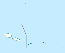
Silisili is located in Samoa
Silisili
Location of Mount Silisili in Samoa
Location Samoa
Coordinates 13°37′06″S 172°29′09″W / 13.61833°S 172.48583°W / -13.61833; -172.48583Coordinates: 13°37′06″S 172°29′09″W / 13.61833°S 172.48583°W / -13.61833; -172.48583[2]

Mount Silisili is the highest peak in Samoa and the Samoa Islands chain. It is located in the centre of a mountain chain running the length of Savai'i island.

Mount Silisili rises to a height of 1,858 m.[3] The word silisili means highest in reference to height, in the Samoan language.

Savai'i is the largest shield volcano island in the South Pacific.

See also

  • Mount Matavanu, active volcano on Savai'i, last erupted 1905 - 1911.
  • Mata o le Afi, a volcano on Savai'i, last erupted 30 October 1902 to 17 November 1902.
  • Mauga Afi, a volcano on Savai'i, last erupted about 1725.

References

  1. ^ a b "Mauga Silisili" on Peakbagger.com Retrieved 1 October 2011
  2. ^ "Mauga Silisili" Peaklist.org - Pacific Islands Retrieved 1 October 2011
  3. ^ Rottman, Gordon L. (2002). World War 2 Pacific island guide. Greenwood Publishing Group. p. 88. ISBN 0-313-31395-4. http://books.google.co.nz/books?id=ChyilRml0hcC&pg=PA88&dq=Silisili+volcano&cd=3#v=onepage&q=Silisili%20volcano&f=false. Retrieved 3 March 2010. 


Wikimedia Foundation. 2010.

Игры ⚽ Поможем решить контрольную работу

Look at other dictionaries:

  • Silisili — Höhe 1.858 m Lage …   Deutsch Wikipedia

  • Monte Silisili — Sim observa en el mapa el centro de la Isla Savai i, se puede ver la presencia del Monte Silisili. El monte Silisili es el pico más alto de Samoa. Está situado en el centro de la isla de Savai i y se eleva a una altura de el 1858 metros. El monte …   Wikipedia Español

  • Mauga Silisili — Le Mauga Silisili est le plus haut sommet de l archipel des Samoa. Il est situé au milieu de l île de Savai i et culmine à 1 858 m[1]. Image satellite de l île de Savai i …   Wikipédia en Français

  • Samoa — This article is about the Independent State of Samoa. For the Samoan Archipelago, see Samoan Islands. For U.S. Territory of American Samoa, see American Samoa. For other uses, see Samoa (disambiguation). Malo Sa oloto Tuto atasi o Samoa… …   Wikipedia

  • Samoan Islands — For other uses, see Samoa (disambiguation). Samoan Islands Olosega island in the Manu a group, eastern Samoa Islands …   Wikipedia

  • Savai'i — Savaii NASA Bild von Savaii Gewässer Pazifischer Ozean Inselgruppe Sam …   Deutsch Wikipedia

  • Savaii — NASA Bild von Savaii Gewässer Pazifischer Ozean Inselgruppe Sam …   Deutsch Wikipedia

  • Geographie des Samoa — Géographie des Samoa Géographie des Samoa Continent Océanie Région Polynésie Coordonnées …   Wikipédia en Français

  • Géographie Des Samoa — Continent Océanie Région Polynésie Coordonnées …   Wikipédia en Français

  • Géographie des Samoa — Continent Océanie Région Polynésie Coordonnées …   Wikipédia en Français

Share the article and excerpts

Direct link
Do a right-click on the link above
and select “Copy Link”