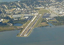
- Merritt Island Airport
-
Merritt Island Airport 
IATA: COI – ICAO: KCOI – FAA LID: COI Summary Airport type Public Owner Titusville-Cocoa Airport Authority Location Merritt Island, Florida Elevation AMSL 7 ft / 2.1 m Coordinates 28°20′30″N 080°41′08″W / 28.34167°N 80.68556°W Runways Direction Length Surface ft m 11/29 3,601 1,098 Asphalt Merritt Island Airport (IATA: COI, ICAO: KCOI, FAA LID: COI) is a general aviation public airport under the administration of the Titusville-Cocoa Airport Authority. It located in Merritt Island, Brevard County, Florida, USA, northwest of Patrick Air Force Base.
Contents
History
In the early 1940s, the Brevard County Mosquito Control District constructed the Central Brevard Airport. The airfield included two sod landing strips:
(1) a north-south strip measuring approximately 1,800 feet in length; and, (2) a northwest southeast strip measuring approximately 3,000 feet in length.
An operations building and maintenance hangar were located on the south side of the airfield and the Mosquito Control District had a maintenance hangar on the north side of the airfield. The north-south landing strip was eventually abandoned, replaced by various facilities such as T-hangars that currently occupy this area. The Brevard County Mosquito Control District subsequently deeded the Central Brevard Airport property over to the Titusville-Cocoa Airport Authority in exchange for ten acres of land located within Space Coast Regional Airport. Central Brevard Airport was renamed Merritt Island Airport and became a public general aviation facility.[1]
Facilities
Merritt Island Airport covers 129 acres (52 ha) and has one runway:
- Runway 11/29: 3,601 x 75 ft. (1,098 x 23 m), Surface: asphalt
Government Activities
- Brevard County Sheriff's Office Aviation Unit
Businesses
- Aerocomp, an airplane manufacturer is located at the Merritt Island Airport.
- Baer Air offers aircraft charters and has a base at the airport.
- Voyager Aviation International offers flight training.
References
- Titusville-Cocoa Airport Authority (official site)
- FAA Airport Master Record for COI (Form 5010 PDF)
External links
- Resources for this airport:
- AirNav airport information for KCOI
- ASN accident history for COI
- FlightAware airport information and live flight tracker
- NOAA/NWS latest weather observations
- SkyVector aeronautical chart, Terminal Procedures for KCOI
Categories:- Airports in Brevard County, Florida
- Merritt Island, Florida
Wikimedia Foundation. 2010.
