- Maitum, Sarangani
-
Maitum — Municipality — 
SealLocation in the Philippines
 Maitum
Coordinates: 6°02′N 124°29′E / 6.033°N 124.483°ECoordinates: 6°02′N 124°29′E / 6.033°N 124.483°E Country  Philippines
Region SOCCSKSARGEN (Region XII) Province Sarangani District Lone district Founded May 7, 1959 Barangays 19 Government - Mayor Elsie Lucille R. Perrett Area - Total 290.66 km2 (112.2 sq mi) Population (2007) - Total 37,054 - Density 127.5/km2 (330.2/sq mi) Time zone PST (UTC+8) ZIP code 9515 Income class 2nd class Website http://www.maitum.gov.ph Population Census of Maitum Census Pop. Rate 2000 35,536 — 2007 37,054 0.58% Maitum is a 2nd class municipality in the province of Sarangani, Philippines. According to the latest census, it has a population of 37,054 people in 7,640 households.
It is bordered on the west by the province of Sultan Kudarat, on the east by the municipality of Kiamba, on the north by the province of South Cotabato, and on the south by the Celebes Sea.
According to the last general elections, it has a total voting population of 18,953 voters.
Contents
Online Presence
You can follow news updates on this websites:
Website : http://www.maitum.gov.ph
Facebook Page : http://www.facebook.com/maitum.sarangani
Twitter : http://www.twitter.com/maitumsarangani
Barangays
Maitum is politically subdivided into 19 barangays.
- Bati-an
- Kalaneg
- Kalaong
- Kiambing
- Kiayap
- Mabay
- Maguling
- Malalag
- Mindupok
- New La Union
- Old Poblacion
- Pangi
- Pinol
- Sison
- Ticulab
- Tuanadatu
- Upo
- Wali
- Zion
History
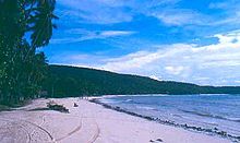 A view of the coastal area
According to local folklore, "Maitum" refers to the black stones in Saub River. It is believed that the river stones turned black when the local native princess and her warrior lover passed through it as they eloped and escaped from the wrath of the princess' father who disapproved their marriage. "Maitum" is a native word meaning black. In 1928, Maitum became part of the municipality of Kiamba. It became a separate municipality on May 7, 1959 through Republic Act No. 2189.
People and culture
The majority of the population are of Ilocano origin. One of the indigenous peoples living in mountainous areas of Maitum is known as T'boli. The annual Binuyugan Festival is celebrated in May.
Internationally, Maitum is known for the discovery of very old cave artifacts called Maitum Anthropomorphic Potteries in one of the caves nearby. Ancient burial jars were discovered by archaeologists from the National Museum in Ayub Cave, Maitum, in 1991 and in 2008, at Sagel Cave, Maitum (now declared by National Historical Institute as a national historical sites). Amid Mindanao's armed conflicts, artifacts found thereat prove settlements of pre-historic civilization in Maitum.[1][2]
Economy
The economy of Maitum is largely based on agriculture and is often called the "rice-granary" of Sarangani due to its high level production of rice. Aqua-culture is the second biggest income earner, notably the culture of milkfish (bangus), prawns (particularly giant prawns) and shrimps for export. Other agricultural products are coconuts, maize, sugarcane, bananas, pineapples, mangoes, pork, eggs, beef, and fish. Maitum is also a food basket nationally famous for its dried fish.
The economy has accelerated in the past decade driven by advances in global communication technology and the finishing of a modern highway that tremendously improved trade and transport.
Wildlife
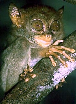
 Tarsier
Tarsiers have been discovered in Maitum's mountainous areas.
Caves and the rainforest of Maitum are the natural habitat of a rare fruit bat species called Giant Golden-crowned Flying Fox (Acedoron jubatus), also known as "silent planter," since it contributes greatly to forest regeneration, because of eating lots of fruits and their seeds.[3] The rare Writhed-billed Hornbill and Tarictic Hornbill are also found in the surrounding rainforest. The Philippine Eagle (a monkey-eating eagle) also thrives in the area.
The endangered Hawksbill Turtles have their nesting grounds in Maitum's former main village called "Old Poblacion".
Other wild animals are wild boar, deer, monkeys, and various species of snake.
Sea turtles or pawikan can also be found in Maitum, Sarangani specifically at the Pawikan Nesting Sanctuary founded in 2003.
External links
- Official Website of the Municipality of Maitum
- Twitter Account
- Facebook Page
- Maitum cave yields artifacts similar to 1991 find
- Philippine Standard Geographic Code
- 1995 Philippine Census Information
- 2000 Philippine Census Information
- 2007 Philippine Census Information
References
Municipalities Categories:- Municipalities of Sarangani


Wikimedia Foundation. 2010.