- Maroslele
-
Maroslele Country  Hungary
County Csongrád Area - Total 46.56 km2 (18 sq mi) Population (2002) - Total 2,199 - Density 47/km2 (121.7/sq mi) Time zone CET (UTC+1) - Summer (DST) CEST (UTC+2) Postal code 6921 Area code(s) 62 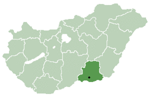
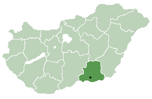
Maroslele is a village in Csongrád county, in the Southern Great Plain region of southern Hungary.
Maroslele - Peace, Space, Community - A Great Place to Live'
Maroslele the Great Plains located between the southeastern part of the Tisza and Maros rivers. Maroslele is a Csongrád County town between three cities, Szeged 7 minutes away via motorway, Makó 10 km, 18 km away to beautiful Hódmezővásárhely.
The village was first mentioned in records dating from 1214. The medieval town of Leléről a single representation has been preserved, named by Lázár Deák (circa 1521). Lele village was founded in 1872.
The Maroslele area features extensive infrastructure including water pipes, public transport, gas lines, telephone, broadband internet and modern electrical network. The government's plans include a development investments, focusing mainly on education and entrepreneurship, innovation, culture, sports and recreation, and target the current regeneration of the town. The livelihood of the farming population and the surrounding towns provides major work opportunities.
Our sustainable agriculture includes many crops, particularly the cultivation of garlic, a village located in the vicinity of the land to one of the best fokhagymatermő (garlic) areas.
The village square is the Roman Catholic Church, which was built in 1902, donated by Bishop Alexander Dessewffy. 1931 - In the village the population to drill water supply wells in the main square, was named to the Heroes qui kútjának. Today the fountain is just a spectacle, the water dried up.
The Local History Collection of an entire village smithy machines. Historical Compendium of The Village Blacksmith for a total machines. The population Served by public education, approximately 10 thousand books in the library and ITS Mediterranean-style courtyard. In addition to regular Internet access for exhibitions, cultural and public events, as well as historical, research and professional performance venue. In Addition to regular Internet access for exhibitions, cultural and public events, and historical, research and professional performance venue.
Modern computer technology and office equipment is available in the local Telehouse, which offers information for visitors.
The annual programs to the surrounding villages also attract visitors. The Annual Programs to the surrounding villages Also ATTRACT visitors. THE SOUL OF DAYS popular and Maria farewell to sun-related, and the Spirit of Summer Nights music programs and Christmas programs. THE SOUL OF DAYS popular Farewell to Maria and sun-related, and the Spirit of Summer Nights music and Programs Christmas Programs. The government plans to set new ambitious programs of music, which as part of a rock music concert series launched. The Government Plans to set ambitious new Programs of Music and art as part of a rock music concert series Launched.
The Mures River floodplain of the Koros-Maros National Park conservation area and those who want to hike in a pleasant environment and enjoy the fresh air. The Mures River floodplain of the Koros-Maros National Park conservation area and those WHO Want to Hike in a pleasant environment and enjoy the fresh air.
Information: 6921 Maroslele, Freedom Square 1 Information: 6921 Maroslele, Freedom Square, a Tel / Fax.: 62/256-033,
Geography
It covers an area of 46.56 km2 (18 sq mi) and has a population of 2199 people (2001).
County seat: Szeged Cities and towns Csanádpalota · Csongrád · Hódmezővásárhely · Kistelek · Makó · Mindszent · Mórahalom · Sándorfalva · Szentes
Villages Algyő · Ambrózfalva · Apátfalva · Árpádhalom · Ásotthalom · Baks · Balástya · Bordány · Csanádalberti · Csanytelek · Csengele · Derekegyház · Deszk · Domaszék · Dóc · Eperjes · Fábiánsebestyén · Felgyő · Ferencszállás · Forráskút · Földeák · Királyhegyes · Kiszombor · Klárafalva · Kövegy · Kübekháza · Magyarcsanád · Maroslele · Mártély · Nagyér · Nagylak · Nagymágocs · Nagytőke · Óföldeák · Ópusztaszer · Öttömös · Pitvaros · Pusztamérges · Pusztaszer · Röszke · Ruzsa · Szatymaz · Szegvár · Székkutas · Tiszasziget · Tömörkény · Újszentiván · Üllés · Zákányszék · ZsombóOther topics History · Geography · Government · Economy · Culture · TourismCoordinates: 46°16′N 20°21′E / 46.267°N 20.35°E
For more information see www.maroslele.hu
Zsuzsannna Molnar is from Maroslele. Gordon Hay and Zsuzsanna were married in Maroslele on Jan 1 2005 in the Catholic Church. Contact Zsuzsanna Molnar Hay @ www.hangolangol.hu
Newspaper article http://www.delmagyar.hu/mako_hirek/maroslelen_verne_gyokeret_a_magyar8211skot_csalad/2138094/#hozzaszolok
Categories:- Populated places in Csongrád county
- Csongrád county geography stubs

Wikimedia Foundation. 2010.