- Kiszombor
Infobox Settlement
settlement_type =
subdivision_type = Country
subdivision_name = HUN
latd= |latm= |lats= |latNS=N
longd= |longm= |longs= |longEW=Epushpin_
pushpin_label_position =
pushpin_map_caption =
pushpin_mapsize =
timezone=CET
utc_offset=+1
timezone_DST=CEST
utc_offset_DST=+2|official_name=Kiszombor
subdivision_type1=County
subdivision_name1=Csongrád
area_total_km2=65.81
population_as_of=2002
population_total=4210
population_density_km2=64
postal_code_type=Postal code
postal_code=6775
area_code=62
[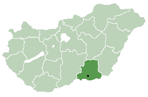 thumb|right|300px|Location_of_
Csongrád County inHungary ] Kiszombor is avillage inCsongrád county, in theSouthern Great Plain region of southernHungary .Geography
It covers an
area of convert|65.81|km2|sqmi|0|abbr=on and has apopulation of 4210 people (2002 ).It is an agricultural village, near the river Maros.With more than its 750 years history it has some antic buildings, for example the Castle Ronay, and the Rotunda which is a church with cirlce-shaped sketch. There are some beautiful wall-paintings in Gothic style which were painted in the XIV. century.The church itself was bulit in Romanesque style in the XIII. century.
There is a border-crossing point near the village, so you can enter Romania if you cross Kiszombor.
There is the "Village-festival" at the third weekend of September in every year where lots of Hungarian artists appear: play, sing, dance and so on.If you're near Kiszombor that time don't forget to drop in.
ightseeing for visitors
In the village we can see an old architectural heritage from the romanesque art: the church. It consists of two parts. Older is the rotunda built with 6 sections. Younger is, the village church. The rotunda has 2 other relatives of this type in the
Carpathian Basin : Gerény andKarcsa .Outer references
* Aradi N. (Ed.): A művészet története Magyarországon. (The History of Arts in Hungary). Gondolat, Budapest
* Fülep L. (Ed.): A magyarországi művészet története. (The History of the Hungarian Arts). Budapest
* Gerevich T.: "Magyarország románkori emlékei". (Die romanische Denkmäler Ungarns.) Egyetemi nyomda. Budapest, 1938.
* Gerő L. : "Magyar műemléki ABC". Budapest, 1984
* Gervers-Molnár, V. (1972): A középkori Magyarország rotundái. (Rotunda in the Medieval Hungary). Akadémiai, Budapest
* Henszlmann, I. (1876): "Magyarország ó-keresztyén, román és átmeneti stylü mű-emlékeinek rövid ismertetése", (Old-Christian, Romanesque and Transitional Style Architecture in Hungary). Királyi Magyar Egyetemi Nyomda, Budapest
* Marosi E.: "A román kor művészete", (Art of the Romanesque Ages). Corvina, Budapest, 1972, ISBN 9631320006ee also
Rotunda (architecture)
Wikimedia Foundation. 2010.