Dunaszentbenedek

Dunaszentbenedek
Dunaszentbenedek
Country  Hungary
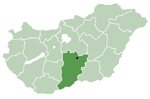
County Bács-Kiskun
Area
 – Total 23.24 km2 (9 sq mi)
Population (2005)
 – Total 960
 – Density 41/km2 (106.2/sq mi)
Time zone CET (UTC+1)
 – Summer (DST) CEST (UTC+2)
Postal code 6333
Area code(s) 78
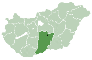
Location of Bács-Kiskun county in Hungary

Dunaszentbenedek (Croatian: Sabendak) is a village and municipality in Bács-Kiskun county, in the Southern Great Plain region of southern Hungary.

Geography

It covers an area of 23.24 km2 (9 sq mi) and has a population of 960 people (2005).It is very nice village, with a sandy beach, a fantastic place for camping.

Coordinates: 46°35′38″N 18°53′31″E / 46.594°N 18.892°E / 46.594; 18.892


Wikimedia Foundation. 2010.

Игры ⚽ Нужно решить контрольную?

Look at other dictionaries:

  • Dunaszentbenedek — 46° 35′ 38″ N 18° 53′ 31″ E / 46.594, 18.892 …   Wikipédia en Français

  • Bács-Kiskun County — Infobox Hungarian county name =Bács Kiskun region =Southern Great Plain seat = Kecskemét area = 8,445 population = 534,000 density = 63 cities = 119Bács Kiskun is a county ( megye in Hungarian; IPA2|baːtʃ kiʃkun) located in southern Hungary. It… …   Wikipedia

  • Csávoly — Csávoly …   Wikipedia

  • Dunavecse — Coat of arms …   Wikipedia

  • Dunapataj — Dunapataj …   Wikipedia

  • Bócsa — Country  Hungary County Bács Kiskun Area  – Total 97.04 km2 (37.5 sq  …   Wikipedia

  • Csólyospálos — File:Csólyospálos címere.jpg Coat of arms …   Wikipedia

  • Ordas — Country  Hungary County Bács Kiskun Area    Total 16.31 km2 (6.3 sq m …   Wikipedia

  • Dunafalva — Dunafalva …   Wikipedia

  • Nagybaracska — Nagybaracska …   Wikipedia

Share the article and excerpts

Direct link
Do a right-click on the link above
and select “Copy Link”