- New York State Route 320
-
NYS Route 320

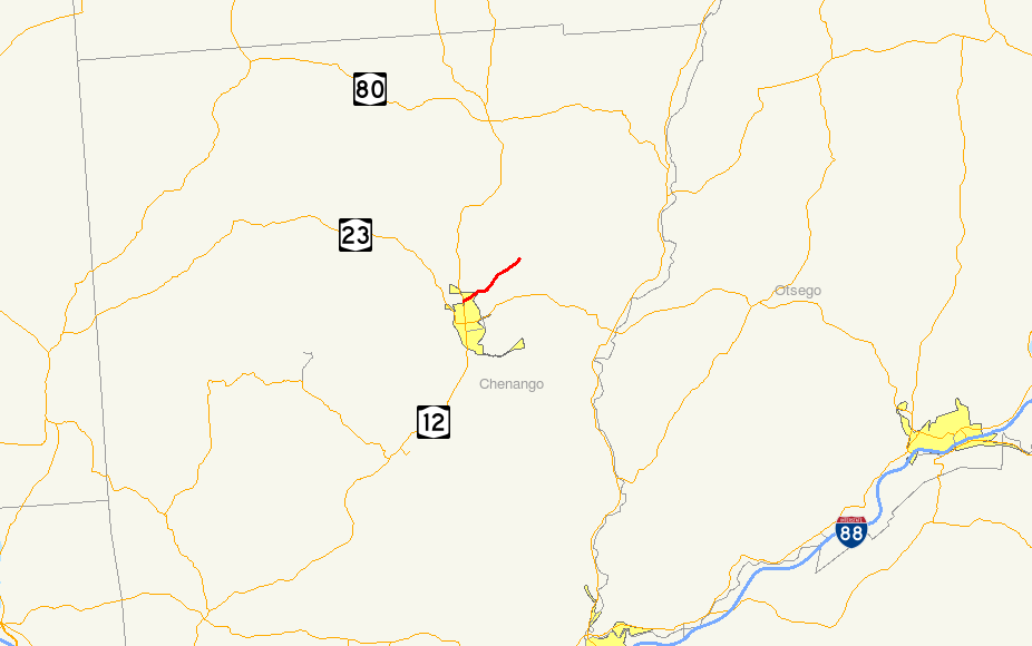
Map of the Norwich area with NY 320 highlighted in redRoute information Maintained by NYSDOT Length: 3.55 mi[2] (5.71 km) Existed: 1930[1] – present Major junctions South end:  NY 12 in Norwich
North end:  CR 29 in North Norwich
Location Counties: Chenango Highway system Numbered highways in New York
Interstate • U.S. • N.Y. (former) • Reference • County←  NY 319
NY 321  →
→New York State Route 320 (NY 320) is an east–west state highway located within Chenango County in the central part of New York, United States. The western terminus of the route is at an intersection with NY 12 immediately north of the city of Norwich in the surrounding town of Norwich. Its eastern terminus is at Tiffany Road in North Norwich, where it continues northeast as County Route 29. NY 320 was assigned as part of the 1930 renumbering of state highways in New York.
Contents
Route description
NY 320
Route 320 begins at an intersection with NY 12 in Norwich. The highway heads eastward, passing small businesses, and crosses over a river. Just after the river, Route 320 passes a suburbanized area, with businesses and homes surrounding the highway for a short distance. As the road leaves Norwich, it intersects with County Route 32, where then the highway becomes a rural road, with houses leading the way. As Route 320 heads to the northeast, a small forest begins to parallel to its south. The forest soon makes way for fields and farms, with the highway heading through rural parts of Chenango County. At the intersection with Tiffany Road, Route 320 ends and the highway becomes County Route 29.[3]
CR 29
CR 29 heads through more rural regions of Chenango County, intersecting with local roads that are surrounded by trees and farms. After passing through Kings Settlement, the highway turns northward towards New Berlin. For a while, there is nothing around the highway until the intersection with County Road 28. County Road 29 heads past a small lake and homes begin to return around the highway. The highway then turns to the southeast, intersecting with local roads and enters the area of New Berlin. There it becomes known as West Street.[4]
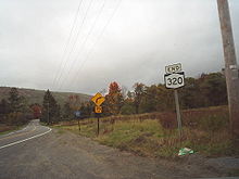 Sign depicting the eastern terminus of NY 320 at Chenango CR 29
In New Berlin, County Road 29 enters the downtown area and terminates at an intersection with NY 8 and NY 80. West Street continues as NY 80 East.[4]
History
NY 320 was assigned as part of the 1930 renumbering of state highways in New York and has not been substantially altered since that time.[1] In 2005, the entirety of the 8.56-mile (13.78 km) County Route 29 was repaved.[5]
Major intersections
The entire route is in Chenango County.
Location Mile[2][5] Destinations Notes Town of Norwich 0.00 NY 12North Norwich 3.55
0.00Tiffany Road Begin CR 29 eastbound and NY 320 westbound Village of New Berlin 8.56 
 NY 8 / NY 80
1.000 mi = 1.609 km; 1.000 km = 0.621 mi References
- ^ a b Automobile Legal Association (ALA) Automobile Green Book, 1930/31 and 1931/32 editions, (Scarborough Motor Guide Co., Boston, 1930 and 1931). The 1930/31 edition shows New York state routes prior to the 1930 renumbering
- ^ a b "2008 Traffic Volume Report for New York State" (PDF). New York State Department of Transportation. June 16, 2009. p. 213. https://www.nysdot.gov/divisions/engineering/technical-services/hds-respository/NYSDOT%20TVR%202008%20by%20Route.pdf. Retrieved February 1, 2010.
- ^ Google, Inc. Google Maps – overview map of NY 320 (Map). Cartography by Google, Inc. http://maps.google.com/maps?sourceid=navclient&ie=UTF-8&rlz=1T4ADBF_enUS232US232&q=from%3A%20RT-320%20%4042.552681%2C%20-75.525656%20to%3A%20RT-320%20%4042.582093%2C%20-75.472106&um=1&sa=N&tab=wl. Retrieved May 10, 2008.
- ^ a b Google, Inc. Google Maps – overview map of Chenango CR 29 (Map). Cartography by Google, Inc. http://maps.google.com/maps?sourceid=navclient&ie=UTF-8&rlz=1T4ADBF_enUS232US232&q=from%3A%20RT-320%20%4042.582093%2C%20-75.472106%20to%3A%20CR-29%2FWest%20St%20%4042.624330%2C%20-75.332404&um=1&sa=N&tab=wl. Retrieved May 10, 2008.
- ^ a b "Chenango County D.P.W. 2005 Proposed Major Projects" (PDF). Chenango County Department of Public Works. 2005. http://www.co.chenango.ny.us/DPW/2005Projects.pdf. Retrieved May 10, 2008.
External links
Categories:- State highways in New York
- Transportation in Chenango County, New York


Wikimedia Foundation. 2010.