- Marmorera
-
Marmorera 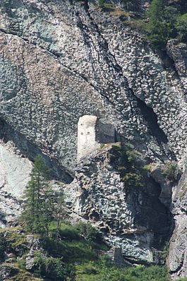
Country Switzerland 
Canton Graubünden District Albula 46°30′N 9°39′E / 46.5°N 9.65°ECoordinates: 46°30′N 9°39′E / 46.5°N 9.65°E Population 42 (Dec 2009)[1] - Density 2 /km2 (6 /sq mi) Area 18.99 km2 (7.33 sq mi) Elevation 1,720 m (5,643 ft) Postal code 7456 SFOS number 3533 Surrounded by Bever, Bivio, Mulegns, Sur Website www.marmorera.ch
SFSO statistics
 Marmorera
View map of Marmorera Marmorera (German: Marmels) is a municipality in the district of Albula in the canton of Graubünden in Switzerland.
Until the end of the 19th century, its population was almost exclusively Romansh-speaking. This figure has however since been in decline, with its 2000 census reporting that 57% of the population now declared German as a first language.
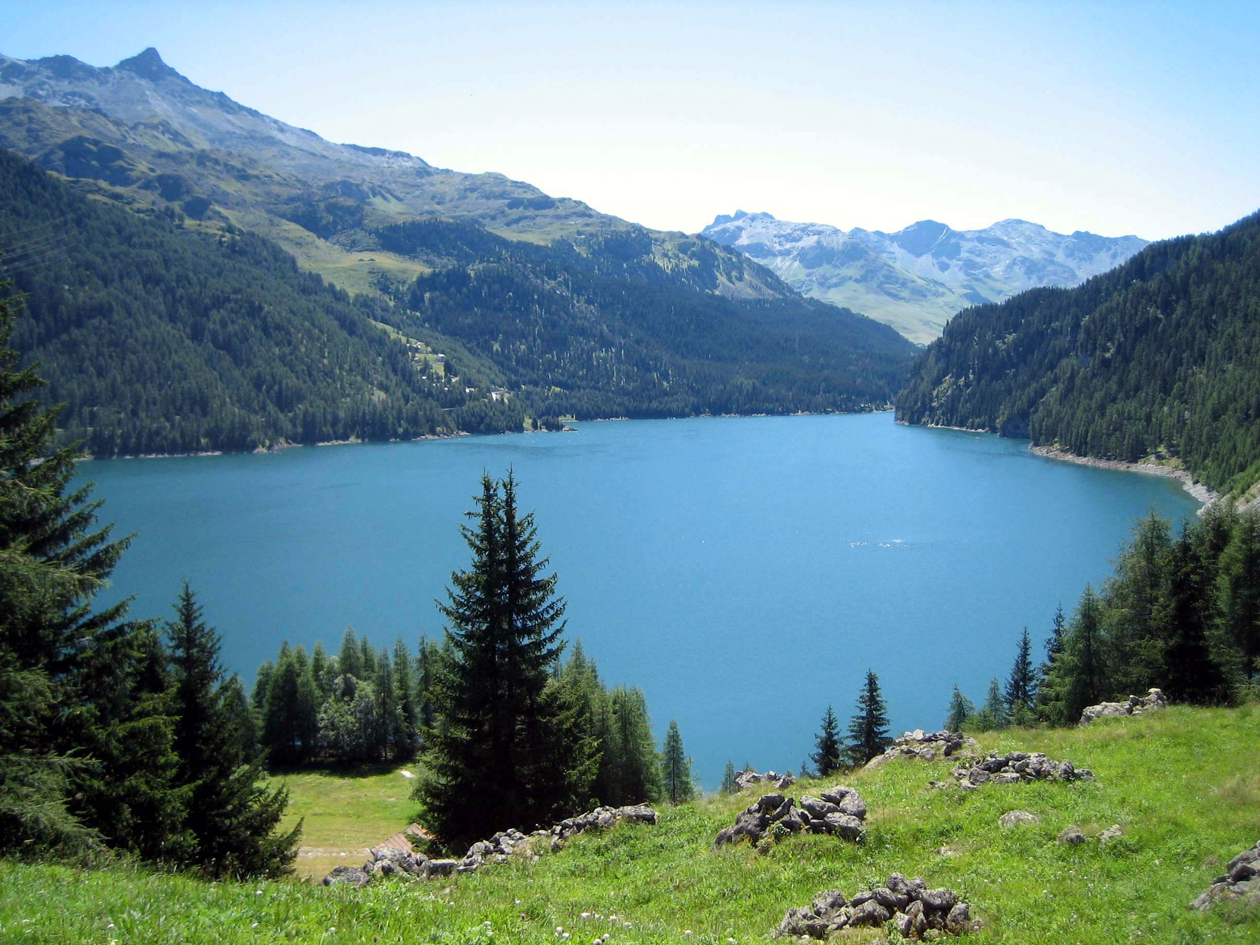
The old village was destroyed and flooded when the Marmorera dam was constructed. The current village was built above Lai da Marmorera.
Contents
History
Marmorera is first mentioned about 840 as ad Marmoraria.[2]
Geography
 Lai da Marmorera, lake formed behind the Marmorera dam
Marmorera has an area, as of 2006[update], of 19 km2 (7.3 sq mi). Of this area, 35.6% is used for agricultural purposes, while 23% is forested. Of the rest of the land, 1% is settled (buildings or roads) and the remainder (40.4%) is non-productive (rivers, glaciers or mountains).[3]
The municipality is located in the Surses sub-district of the Albula district. Until 1950 it was a linear village on the Septimer-Julier-Route, but was destroyed and flooded when the Marmorera dam was constructed. Today it is located on the eastern shore of the Lai da Marmorera (Marmorera lake). Until 1902 Marmorera was known as Marmels.[4]
Demographics
Marmorera has a population (as of 31 December 2009) of 42.[1] As of 2008[update], 2.1% of the population was made up of foreign nationals. Over the last 10 years the population has decreased at a rate of -11.1%. Most of the population (as of 2000[update]) speaks German (57.1%), with Romansh being second most common (34.7%) and Italian being third ( 6.1%).[3]
As of 2000[update], the gender distribution of the population was 47.9% male and 52.1% female.[5] The age distribution, as of 2000[update], in Marmorera is; 2 people or 4.1% of the population are between 0 to 9 years old. 4 people or 8.2% are 10 to 14, and 4 people or 8.2% are 15 to 19. Of the adult population, 2 people or 4.1% of the population are between 20 to 29 years old. 5 people or 10.2% are 30 to 39, 8 people or 16.3% are 40 to 49, and 9 people or 18.4% are 50 to 59. The senior population distribution is 9 people or 18.4% of the population are between 60 to 69 years old, 4 people or 8.2% are 70 to 79, there are 2 people or 4.1% who are 80 to 89.[6]
In the 2007 federal election the most popular party was the SVP which received 51.2% of the vote. The next three most popular parties were the CVP (20.9%), the SPS (14%) and the FDP (9.3%).[3]
The entire Swiss population is generally well educated. In Marmorera about 85.2% of the population (between age 25-64) have completed either non-mandatory upper secondary education or additional higher education (either university or a Fachhochschule).[3]
Marmorera has an unemployment rate of 0%. As of 2005[update], there were 2 people employed in the primary economic sector and 1 business involved in this sector. No one is employed in the secondary sector. 7 people are employed in the tertiary sector, with 2 businesses in this sector.[3]
The historical population is given in the following table:[2][5]
year population 1850 156 1900 143 1920 100 1941 94 1950 140 1960 28 1970 27 1980 27 1990 38 2000 138 Heritage sites of national significance
The ruins of old Marmorera are listed as a Swiss heritage sites of national significance.[7]
References
- ^ a b Swiss Federal Statistical Office, MS Excel document – Bilanz der ständigen Wohnbevölkerung nach Kantonen, Bezirken und Gemeinden (German) accessed 25 August 2010
- ^ a b Marmorera in German, French and Italian in the online Historical Dictionary of Switzerland.
- ^ a b c d e Swiss Federal Statistical Office accessed 24-Sep-2009
- ^ Amtliches Gemeindeverzeichnis der Schweiz published by the Swiss Federal Statistical Office (German) accessed 23 September 2009
- ^ a b Graubunden in Numbers (German) accessed 21 September 2009
- ^ Graubunden Population Statistics (German) accessed 21 September 2009
- ^ Swiss inventory of cultural property of national and regional significance 21.11.2008 version, (German) accessed 24-Sep-2009
External links
- Official website (German)
- Marmorera in German, French and Italian in the online Historical Dictionary of Switzerland.
Alvaneu | Alvaschein | Bergün/Bravuogn | Bivio | Brienz/Brinzauls | Cunter | Filisur | Lantsch/Lenz | Marmorera | Mon | Mulegns | Mutten | Riom-Parsonz | Salouf | Savognin | Schmitten | Stierva | Sur | Surava | Tiefencastel | Tinizong-Rona | Vaz/Obervaz |
Graubünden | Districts of Canton Graubünden | Municipalities of the canton of Graubünden
 Categories:
- Municipalities of Graubünden
- Municipalities of Switzerland
- Cultural property of national significance in the canton of Graubünden


Wikimedia Foundation. 2010.