- Olallie Scenic Area
-
Olallie Lake 
Olallie Lake and Mount Jefferson Location Jefferson / Marion counties, Oregon, USA Coordinates 44°48′25″N 121°47′15″W / 44.80694°N 121.7875°WCoordinates: 44°48′25″N 121°47′15″W / 44.80694°N 121.7875°W[1] Lake type mountain Basin countries United States Surface area 240 acres (97 ha) Average depth 17 ft (5.2 m)[2] Max. depth 43 ft (13 m)[2] Water volume 5,001,333 cubic yards (3,823,793 m3)[2] Shore length1 3.9 miles (6.3 km)[2] Surface elevation 4,941 ft (1,506 m)[1] 1 Shore length is not a well-defined measure. Olallie Scenic Area is a United States Forest Service designated scenic area located in Oregon’s Cascade Mountains. It is between Mount Hood on the north and Mount Jefferson to the south and contains Olallie Lake along with several smaller lakes. The name Olallie is Chinook Jargon for berry.[2]
Contents
Details
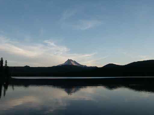
The glaciated region is roughly 89% forested with Noble fir, western hemlock, cedar species, pacific silver fir, mountain hemlock and several other tree species.[2] Crossed by the Pacific Crest Trail,[3] Olallie is in the shadow of Mount Jefferson within the Mount Hood National Forest. The volcanic peaks of 10,497 feet (3,199 m) Mount Jefferson and 7,215 ft (2,199 m) Olallie Butte, both located on the border of the Warm Springs Indian Reservation, overlook the area from the south and north. There are some meadows and marshes, with Olallie Meadow at 100 acres (40 ha) being the largest, and home to a former ranger station.[2] Olallie Lake Guard Station is listed on the National Register of Historic Places and is near the west end of Olallie Lake.
Recreation includes camping at Forest Service improved campgrounds, cabins and yurts at the Olallie Lake Resort.[4] The use of motor boats is prohibited on the snow melt fed alpine lakes by state law;[5] the Olallie Resort has paddle boats and rowboats for rent. Access is via Forest Road 46 to Forest Road 4690 to Forest Road 4220 or from Forest Road 42 to Forest Road 4220. These roads are closed in the winter. The last few miles of Forest Road 4220 are gravel. The Scenic Area has seven campgrounds, Olallie Meadows, Camp Ten, Paul Dennis, Peninsula, Lower Lake, Horseshoe Lake, and Triangle Lake Equestrian.
Lakes
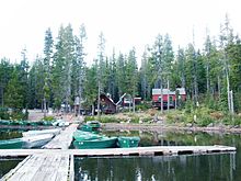 Olallie Lake Resort's boat dock
Located in Jefferson and Marion counties at 4,500 feet (1,400 m) above sea level the area is home to over 200 lakes in the Scenic Area that lies in the shadow of Olallie Butte.[2] The largest of these lakes is the namesake Olallie Lake that has a 3.9 miles (6.3 km) shoreline.[2] The lake sits at 4,900 feet (1,500 m) and is 240 acres (0.97 km2) in size and has a maximum depth of 43 feet (13 m).[2][6] The Oregon Department of Fish and Wildlife stocks the lake with both Rainbow trout and Brook trout.[6] Mill Creek on the eastern shore is the only outflow, and it has a small dam to help keep water levels constant.[2] Other lakes include Long, Monon, Lower, Dark, Gifford, and Fish.[2]
See also
References
- ^ a b "Olallie Lake". Geographic Names Information System, U.S. Geological Survey. http://geonames.usgs.gov/pls/gnispublic/f?p=gnispq:3:::NO::P3_FID:1147178. Retrieved 2008-12-10.
- ^ a b c d e f g h i j k l Johnson, D. M. (1985). Atlas of Oregon Lakes. Corvallis, Or: Oregon State University Press. pp. 108-109.
- ^ Oregon Segment of the Pacific Crest Trail. Pacific Crest National Scenic Trail. Retrieved on February 22, 2008.
- ^ Olallie Lake Resort - Oregon's High Mountain Getaway. Olallie Lake Resort. Retrieved on February 23, 2008.
- ^ O.R.S. 830.180
- ^ a b Lakes of the Mt Hood National Forest. United States Forest Service. Retrieved on February 23, 2008.
External links
Categories:- Cascade Range
- Protected areas of Oregon
- Protected areas of Jefferson County, Oregon
- Protected areas of Marion County, Oregon
- Mount Hood National Forest

Wikimedia Foundation. 2010.