Czarny Staw pod Rysami

Czarny Staw pod Rysami
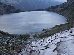
viewed from the southwest, with permanent snowdrift
Location Tatra mountains
Coordinates 49°11′18″N 20°4′34″E / 49.18833°N 20.07611°E / 49.18833; 20.07611Coordinates: 49°11′18″N 20°4′34″E / 49.18833°N 20.07611°E / 49.18833; 20.07611
Basin countries Poland
Max. depth 76 m
Surface elevation 1,583 m

Czarny Staw pod Rysami (Black Lake below Mount Rysy) is a mountain lake on the Polish side of Mount Rysy in the Tatra mountains. At 1,583 m above sea level, it overlooks the nearby lake of Morskie Oko. Its maximum depth is 76 m. A walking path circumnavigates the lake, and leads up to Mount Rysy, or down to Morskie Oko.

To get to Czarny Staw from Morskie Oko you must follow the red trail on the Eastern side of Morskie Oko. Once you have reached about half-way you will see a signpost that has directions on how to get to Czarny Staw. Just go up the rocky path and you are there! The trip takes about 50 mins going up and 40 mins going back down.

External links

Images

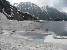
Czarny Staw pod Rysami in May

Wikimedia Foundation. 2010.

Игры ⚽ Нужна курсовая?

Look at other dictionaries:

  • Czarny Staw pod Rysami — depuis les flan du mont Rysy, en contre bas le lac Morskie Oko Administration Pays …   Wikipédia en Français

  • Tatra (Gebirge) — p1p5 Tatra Luftbild: Blick auf die Hohe Tatra von Norden (Polen) Höchster Gipfel Gerlachovský štít (Gerlsdorfer Spitze) ( …   Deutsch Wikipedia

  • Schwarzer Teich — bezeichnet Černý rybník bei Seiffen in Tschechien Czarny Staw pod Rysami in der Hohen Tatra, Polen Czarny Staw Gąsienicowy, desgleichen Czarny Staw Polski, ebenfalls in der polnischen Tatra Schwarzer Teich (Carlsfeld) bei Carlsfeld in Sachsen und …   Deutsch Wikipedia

  • High Tatras — Vysoké Tatry, Tatry Wysokie Mountain Range …   Wikipedia

  • Hohe Tatra — p1 Hohe Tatra Malá Studená dolina (Hohe Tatra, Slowakische Republik) Höchster Gipfel Gerlachovský štít (Gerlsdorfer Spitze) ( …   Deutsch Wikipedia

  • Hautes Tatras — Pour les articles homonymes, voir Hautes Tatras (homonymie). Hautes Tatras …   Wikipédia en Français

  • Rysy — Le sommet du mont Rysy Géographie Altitude 2 503 m Massif Hautes Tatras (Carpates) …   Wikipédia en Français

  • Liste der Seen in Polen — Seen nach Größe Name Flusssystem Fläche (km²) Tiefe (m) Höhe über Meeresspiegel m ü.NHN Śniardwy (Spirdingsee) Pisa 113,8 23,4 116,1 Mamry (Mauersee) …   Deutsch Wikipedia

  • Poland — Polska redirects here. For other uses, see Polska (disambiguation). This article is about the country. For other uses, see Poland (disambiguation). Republic of Poland Rzeczpospolita Polska …   Wikipedia

  • Cliff — Precipice redirects here. For other uses, see Precipice (disambiguation). Rock face redirects here. For other uses, see Rock face (disambiguation). For other uses, see Cliff (disambiguation). The Trango Towers in Pakistan. Their vertical faces… …   Wikipedia

Share the article and excerpts

Direct link
Do a right-click on the link above
and select “Copy Link”