- Illinois' 17th congressional district
Infobox U.S. congressional district
state = Illinois
district number = 17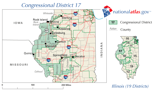
image width = 300px
image caption = The 17th congressional district of Illinois
representative =Phil Hare
party = Democratic
english area =
metric area =
percent urban =
percent rural =
population = 653,647
population year = 2000
median income = 35,066
percent white = 89.0
percent black = 7.2
percent native american = 0.2
percent asian = 0.6
percent hispanic = 3.7
percent other race = 1.3
percent blue collar =
percent white collar =
percent gray collar =
cpvi = D + 5The 17th Congressional District of
Illinois covers much of west central Illinois, including the cities of Sterling, Rock Island, Moline, Kewanee, Galesburg, Canton, Macomb, Quincy, Springfield and Decatur, and areas in Henry, Whiteside, Rock Island, Mercer, Knox, Warren, Henderson, Fulton, McDonough, Hancock, Adams, Pike, Calhoun, Greene, Jersey, Macoupin, Madison, Montgomery, Christian, Sangamon, Macon, Shelby, and Fayette counties. It has been represented by DemocratPhil Hare since2007 .ee also
Gerrymander External links
* [http://projects.washingtonpost.com/elections/keyraces/census/il/district-17/ "Washington Post" page on the 17th District of Illinois]
* [http://fastfacts.census.gov/servlet/CWSFacts?_event=ChangeGeoContext&geo_id=50000US1717&_geoContext=01000US%7C04000US17%7C50000US1716&_street=&_county=&_cd=50000US1717&_cityTown=&_state=04000US17&_zip=&_lang=en&_sse=on&ActiveGeoDiv=&_useEV=&pctxt=fph&pgsl=500&_content=&_keyword=&_industry= U.S. Census Bureau - 17th District Fact Sheet]
*PDFlink| [http://www2.census.gov/geo/maps/cong_dist/cd108_named/ind_pdf/IL_CD17n.pdf U.S. Census Bureau - 17th District map] |6.29 MiB
Wikimedia Foundation. 2010.