- Virginia's 1st congressional district
Infobox U.S. congressional district
state = Virginia
district number = 1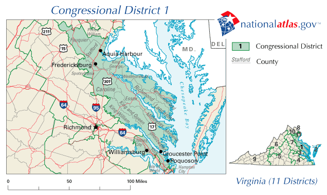
image width = 300
image caption =
representative =Rob Wittman
party = Republican
english area =
metric area =
percent urban =
percent rural =
population = 643,514
population year = 2000
median income = 50,257
percent white = 76.1
percent black = 18.6
percent asian = 1.7
percent native american = 0.4
percent hispanic = 3.0
percent other race = 0.4
percent blue collar =
percent white collar =
percent gray collar =
cpvi = R+9Virginia's first congressional district is a United States congressional district in the commonwealth of
Virginia .Area covered
It covers all or part of the following political subdivisions:
Counties
*Caroline
*Charles City
*Essex
*Fauquier
*Gloucester
*James City
*King and Queen
*King George
*King William
*Lancaster
*Mathews
*Middlesex
*Richmond
*Spotsylvania
*Stafford
*Westmoreland
*York
*Prince WilliamCities
The entirety of:
*Fredericksburg
*Poquoson
*WilliamsburgPortions of:
*Hampton
*Newport NewsThe seat is currently held by Republican
Rob Wittman .Historic District Boundaries
The Virginia First District started in 1788 covering the counties of Ohio, Monongalia,
Harrison County, West Virginia , Frederick,Shenandoah County, Virginia , Berkeley, Hampshire, Hardy, Randolph, and Harrison. [Parsons, Stanley B., William W. Beach and Dan Hermann. "United States Congressional Districts, 1788-1841" (Westport: Greenwood Press, 1978) p. 7] Of these only Shenandoah and Frederick Counties are in Virginia today, the rest are now part ofWest Virginia . The modern counties of Clarke, Warren and most of Page as well as the independent city of Winchester were included as part of Frederick and Shenandoah counties in 1788. In West Virginia all the current state north and east of a generalized line running from Wood County to Pocahontas County was in the congressional district. The one exception was thatPendleton County, West Virginia was inVirginia's 3rd congressional district .In the redistribution which followed the 1850 census (in force 1853-1863), the First District comprised sixteen counties in eastern Virginia. The counties included (amongst others) Accomack, Essex, Gloucester, James City, King and Queen, Mathews, Middlesex, New Kent, Richmond, Warwick and Westmoreland. In an 1862 Union special election three out of the sixteen counties in the Union district supplied returns.
A similar but smaller area than the pre-existing Union district comprised the Confederate First Congressional District of Virginia (used for the
Confederate House of Representatives 1862-1865). This district included the eastern Virginia counties of Accomack, Essex, Gloucester, King and Queen, King William, Lancaster, Mathews, Middlesex, Northampton, Northumberland, Richmond and Westmoreland. [Martis, Kenneth C. "The Historical Atlas of the Congresses of the Confederate States of America: 1861-1865" (Simon and Schuster, 1994)]Representatives
ee also
*
Virginia's 1st congressional district special election, 2007
*Virginia's 1st congressional district election, 2008 External links
*http://www.va1gop.org/
*http://www.1stcdvademocrats.info/
*http://www.govtrack.us/congress/findyourreps.xpd?state=VA&district=1Notes
Wikimedia Foundation. 2010.