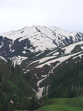
Makra Peak

Makra Peak
Makra Peak
Elevation 3,586 m (11,765 ft)
Listing List of mountains in Pakistan
Location
Location Pakistan
Range Himalayas
Coordinates 34°34′26″N 73°29′43″E / 34.57389°N 73.49528°E / 34.57389; 73.49528Coordinates: 34°34′26″N 73°29′43″E / 34.57389°N 73.49528°E / 34.57389; 73.49528
Climbing
Easiest route Hike

Makra is a scenic peak in the Hazara region of the Himalayas in northern Pakistan. It is 3,586 metres (11,765 ft) high and almost 200 km from Islamabad on Naran Road. From Kiwai a single 7-KM road goes upwards to Shogran, a tourist place with plenty of hotels; the track goes upward to Seree Lake and ends at Paye. From here it is a walking trek of four hours to the top of Makra. Hiking Makra is difficult task due to snow and slop of the peak.

Although it can be normal peak to climb, deaths have occurred in storms. In spite of the difficulties, the top offers the scenery of Hazara and Azad Kashmir.

Waters of its glacier feed the Kunhar River.


Wikimedia Foundation. 2010.

Игры ⚽ Поможем написать реферат

Look at other dictionaries:

  • Makra — may refer to: Makra, Greece, an island in Greece Makra Peak, a mountain peak in Pakistan This disambiguation page lists articles about distinct geographical locations with the same name. If an internal link led you h …   Wikipedia

  • Makra — Höhe 3.586 m …   Deutsch Wikipedia

  • Naran Valley — Main article: Kaghan Valley Kunhar river in Naran valley during the month of June as viewed from PTDC motel Naran Valley (Urdu: وادی ناران) is located in Khyber Pakhtunkhwa, Pakistan. The …   Wikipedia

  • Naran Valley — Das Naran Tal (englisch: Naran Valley, Urdu: وادی ناران) ist ein Tal in der Nordwestprovinz, Pakistan. Es wird vom Fluss Kunhar durchflossen. Hauptattraktionen sind Makra Peak, Malka Parbat und Saiful Muluk. Der Fluss Kunhar im Naran Tal …   Deutsch Wikipedia

  • Mansehra District —   District   Location of Mansehra District (highlighted in yellow) within the Khyber Pakhtunkhwa Province. Countr …   Wikipedia

  • Kunhar River — The Kunhar River (Urdu: دریائے کنہار) is located in North West Frontier Province, Pakistan. A main source of the river is Lulusar lake, nearly 48km from Naran Valley. Glaciers of Malka Parbat and Makra Peak and the waters of Saiful Muluk lake… …   Wikipedia

  • Payee Lake — Infobox lake lake name = Siri Lake image lake = Payee Lake Background View July 8 2007.jpg caption lake = image bathymetry = caption bathymetry = location = Kaghan Valley coords = type = inflow = outflow = catchment = basin countries = Pakistan… …   Wikipedia

  • Shogran — village is situated on a green plateau in northern Pakistan at a height of 2,362 meters above sea level. It is only 10 km from village Kiwai or 34 km from Balakot. The road from Islamabad to Kiwai is metalled and measures 212 km. From Shogran,… …   Wikipedia

  • Chilika Lake — Chilka Lake Fishermen pushing against the tide Coordinates …   Wikipedia

  • Naran-Tal — Das Naran Tal (englisch: Naran Valley, Urdu: وادی ناران) ist ein Tal in der pakistanischen Provinz Khyber Pakhtunkhwa. Es wird vom Fluss Kunhar durchflossen. Hauptattraktionen sind Makra, Malka Parbat und Saiful Muluk. Der Fluss Kunhar im Naran… …   Deutsch Wikipedia

Share the article and excerpts

Direct link
Do a right-click on the link above
and select “Copy Link”